
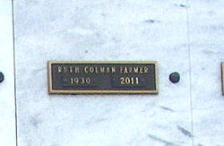
Ruth Colman Farmer
| Birth | : | 10 Jan 1930 Sparta, Monroe County, Wisconsin, USA |
| Death | : | 25 Mar 2011 Myrtle Beach, Horry County, South Carolina, USA |
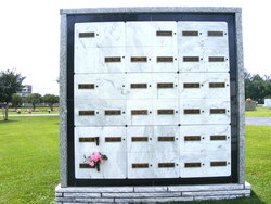
| Burial | : | Sunday River Cemetery, Newry, Oxford County, USA |
| Coordinate | : | 44.4888992, -70.8431015 |
| Description | : | Ruth C. Farmer January10, 1930 - March 25, 2011 North Myrtle Beach, SC Ruth Colman Farmer, 81, of North Myrtle Beach, SC passed away March 25, 2011. She was born January 10, 1930 in Sparta, Wisconsin to the late Russel Benjamin 'Bud' and Olive Colman. She was preceded in death by her husband of 44 years, George Patrick Farmer. Ruth grew up in Wisconsin partially explaining her passion for the Green Bay Packers and sensible warm approach to life. Ruth attended Elon College. Ruth was a resident of North Myrtle Beach for the past 15 years. She lived a full... Read More |
frequently asked questions (FAQ):
-
Where is Ruth Colman Farmer's memorial?
Ruth Colman Farmer's memorial is located at: Sunday River Cemetery, Newry, Oxford County, USA.
-
When did Ruth Colman Farmer death?
Ruth Colman Farmer death on 25 Mar 2011 in Myrtle Beach, Horry County, South Carolina, USA
-
Where are the coordinates of the Ruth Colman Farmer's memorial?
Latitude: 44.4888992
Longitude: -70.8431015
Family Members:


Flowers:


Nearby Cemetories:
1. Sunday River Cemetery
Newry, Oxford County, USA
Coordinate: 44.4888992, -70.8431015
2. Old Powers Cemetery
Newry, Oxford County, USA
Coordinate: 44.5031013, -70.8178024
3. Black Family Cemetery
Newry, Oxford County, USA
Coordinate: 44.4889670, -70.7895730
4. Mount Will Cemetery
North Bethel, Oxford County, USA
Coordinate: 44.4636002, -70.8028030
5. Middle Intervale Cemetery
Bethel, Oxford County, USA
Coordinate: 44.4638600, -70.7866200
6. Ketchum Cemetery
Ketchum, Oxford County, USA
Coordinate: 44.5026880, -70.9135670
7. Capen Family Cemetery
Bethel, Oxford County, USA
Coordinate: 44.4382283, -70.7925117
8. Bartlett Cemetery
East Bethel, Oxford County, USA
Coordinate: 44.4817009, -70.7433014
9. Riverside Cemetery
Bethel, Oxford County, USA
Coordinate: 44.4202995, -70.8058014
10. Hanover Cemetery
Hanover, Oxford County, USA
Coordinate: 44.4850006, -70.7332993
11. Head of Tide Cemetery
Newry, Oxford County, USA
Coordinate: 44.5682424, -70.8634963
12. Skillingston Cemetery
Bethel, Oxford County, USA
Coordinate: 44.4085999, -70.8197021
13. Pine Grove Cemetery
West Bethel, Oxford County, USA
Coordinate: 44.4055600, -70.8563100
14. Chapman Cemetery
Gilead, Oxford County, USA
Coordinate: 44.4114100, -70.9024900
15. Chandler Hill Cemetery
Bethel, Oxford County, USA
Coordinate: 44.4392014, -70.7394028
16. East Bethel Cemetery
East Bethel, Oxford County, USA
Coordinate: 44.4648500, -70.7210200
17. Scribner Hill Cemetery Upper Yard
Otisfield, Oxford County, USA
Coordinate: 44.3903181, -70.7978794
18. Woodland Cemetery
Bethel, Oxford County, USA
Coordinate: 44.3902283, -70.7967911
19. South Bethel Cemetery
Bethel, Oxford County, USA
Coordinate: 44.4160995, -70.7363968
20. Peabody Cemetery
Gilead, Oxford County, USA
Coordinate: 44.3987885, -70.9400635
21. Flat Cemetery
West Bethel, Oxford County, USA
Coordinate: 44.3731003, -70.8497009
22. Rumford Corner Cemetery
Rumford Corner, Oxford County, USA
Coordinate: 44.4955200, -70.6762500
23. Upper West Ellis Cemetery
Rumford, Oxford County, USA
Coordinate: 44.5456009, -70.6941986
24. Rumford Point Cemetery
Rumford Point, Oxford County, USA
Coordinate: 44.5020760, -70.6725600