
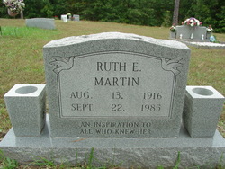
Ruth E. Martin
| Birth | : | 13 Aug 1916 Shannon County, Missouri, USA |
| Death | : | 22 Sep 1985 Mountain View, Howell County, Missouri, USA |
| Burial | : | Agecroft Cemetery and Crematorium, Salford, Metropolitan Borough of Salford, England |
| Coordinate | : | 53.5100250, -2.2940500 |
| Inscription | : | An Inspiration To All Who Knew Her |
| Description | : | Ruth Essie Martin was born Aug. 13, 1916 in Shannon County, Mo., the daughter of Oliver and Alice Nichols Martin and passed away Sept. 22, 1985 at St. Francis Hospital in Mountain View, Mo. at the age of 69 years. Ruth, as she was known to her many friends and relatives was a native of Winona, Mo. and was born and raised in and around the community known as Rocky. She was preceded in death by her mother and father, two sisters, one brother, one grandson, one son-in-law, and one sister-in-law. She is survived by her four children, Elaine (Cowen)... Read More |
frequently asked questions (FAQ):
-
Where is Ruth E. Martin's memorial?
Ruth E. Martin's memorial is located at: Agecroft Cemetery and Crematorium, Salford, Metropolitan Borough of Salford, England.
-
When did Ruth E. Martin death?
Ruth E. Martin death on 22 Sep 1985 in Mountain View, Howell County, Missouri, USA
-
Where are the coordinates of the Ruth E. Martin's memorial?
Latitude: 53.5100250
Longitude: -2.2940500
Family Members:
Parent
Siblings
Flowers:


Nearby Cemetories:
1. Agecroft Cemetery and Crematorium
Salford, Metropolitan Borough of Salford, England
Coordinate: 53.5100250, -2.2940500
2. Agecroft Jewish Cemetery
Pendlebury, Metropolitan Borough of Salford, England
Coordinate: 53.5110302, -2.2955830
3. Rainsough Jewish Cemetery
Prestwich, Metropolitan Borough of Bury, England
Coordinate: 53.5185530, -2.2906950
4. St John The Evangelist Churchyard
Pendlebury, Metropolitan Borough of Salford, England
Coordinate: 53.5036200, -2.3088500
5. St Paul's Churchyard
Salford, Metropolitan Borough of Salford, England
Coordinate: 53.5148800, -2.2725500
6. Saint Augustine's Churchyard
Pendlebury, Metropolitan Borough of Salford, England
Coordinate: 53.5107070, -2.3223960
7. St. Thomas' Churchyard
Salford, Metropolitan Borough of Salford, England
Coordinate: 53.4921430, -2.2856130
8. St. Mary the Virgin Churchyard
Prestwich, Metropolitan Borough of Bury, England
Coordinate: 53.5294033, -2.2864891
9. Great Synagogue Cemetery
Prestwich, Metropolitan Borough of Bury, England
Coordinate: 53.5315510, -2.2845730
10. St. Paul's Wesleyan Methodist Churchyard
Swinton, Metropolitan Borough of Salford, England
Coordinate: 53.5133900, -2.3397500
11. St. Peter's Churchyard
Swinton, Metropolitan Borough of Salford, England
Coordinate: 53.5119130, -2.3413860
12. St. Marks' Churchyard
Cheetham Hill, Metropolitan Borough of Manchester, England
Coordinate: 53.5113780, -2.2462660
13. Wesleyan Methodist Cemetery
Crumpsall, Metropolitan Borough of Manchester, England
Coordinate: 53.5142870, -2.2447610
14. Weaste Cemetery
Weaste, Metropolitan Borough of Salford, England
Coordinate: 53.4795227, -2.3017540
15. Swinton Cemetery
Swinton, Metropolitan Borough of Salford, England
Coordinate: 53.5183372, -2.3457739
16. St Anne Churchyard
Clifton, Metropolitan Borough of Salford, England
Coordinate: 53.5277070, -2.3391650
17. Strangeways Prison Cemetery (Defunct)
Manchester, Metropolitan Borough of Manchester, England
Coordinate: 53.4925000, -2.2463890
18. Irwell Street Wesleyan Chapel Cemetery
Salford, Metropolitan Borough of Salford, England
Coordinate: 53.4829750, -2.2587540
19. Manchester Reform Jewish Old Cemetery
Whitefield, Metropolitan Borough of Bury, England
Coordinate: 53.5442728, -2.2918894
20. New Jerusalem Temple Cemetery
Salford, Metropolitan Borough of Salford, England
Coordinate: 53.4827720, -2.2571250
21. St Mary the Virgin Churchyard
Eccles, Metropolitan Borough of Salford, England
Coordinate: 53.4843810, -2.3346810
22. St Luke's Churchyard
Cheetham Hill, Metropolitan Borough of Manchester, England
Coordinate: 53.5041660, -2.2354680
23. Christ Church
Salford, Metropolitan Borough of Salford, England
Coordinate: 53.4864284, -2.2497653
24. St Chad's Churchyard
Cheetham Hill, Metropolitan Borough of Manchester, England
Coordinate: 53.4922100, -2.2400500