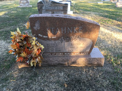
Ruth L. Hoppens Stahnke
| Birth | : | 18 Apr 1917 |
| Death | : | 17 Aug 1999 Hastings, Adams County, Nebraska, USA |
| Burial | : | Totara Memorial Park, Thames, Thames-Coromandel District, New Zealand |
| Coordinate | : | -37.1653440, 175.5590990 |
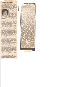
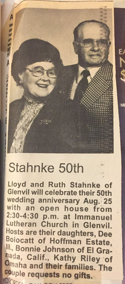
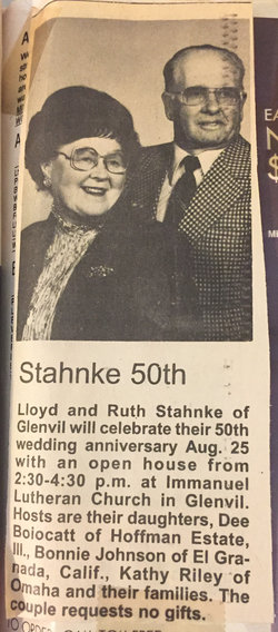
| Description | : | Married 3 September 1941 Lloyd J. Stahnke. --------------- Printed in the Hastings Tribune: Hastings resident Ruth L. (Hoppens) Stahnke, 82, of 1032 Lane K died Tuesday, Aug, 17, 1999, at Mary Lanning Memorial Hospital in Hastings.Services were held Friday at Immanuel Church in Glenvil with the Rev. Tim Wiggins officiating. Burial in the Glenvil Cemetery. Visitation was Thursday at Butler-Volland Funeral Home in Hastings and at Friday at the church.Mrs. Stahnke was born April 18, 1917, to Frank and Ella (Schultz) Hoppens in Clay County. On Sept. 3, 1941, she married Lloyd J. Stahnke at Zion Lutheran Church near Glenvil. She and her... Read More |
frequently asked questions (FAQ):
-
Where is Ruth L. Hoppens Stahnke's memorial?
Ruth L. Hoppens Stahnke's memorial is located at: Totara Memorial Park, Thames, Thames-Coromandel District, New Zealand.
-
When did Ruth L. Hoppens Stahnke death?
Ruth L. Hoppens Stahnke death on 17 Aug 1999 in Hastings, Adams County, Nebraska, USA
-
Where are the coordinates of the Ruth L. Hoppens Stahnke's memorial?
Latitude: -37.1653440
Longitude: 175.5590990
Family Members:
Parent
Spouse
Siblings
Flowers:
Nearby Cemetories:
1. Totara Memorial Park
Thames, Thames-Coromandel District, New Zealand
Coordinate: -37.1653440, 175.5590990
2. Parawai Māori Cemetery
Parawai, Thames-Coromandel District, New Zealand
Coordinate: -37.1590100, 175.5640600
3. Shortland Cemetery
Thames, Thames-Coromandel District, New Zealand
Coordinate: -37.1423500, 175.5571520
4. Tararu Cemetery
Thames, Thames-Coromandel District, New Zealand
Coordinate: -37.1049590, 175.5189510
5. Ngatea Memorial Walls
Ngatea, Hauraki District, New Zealand
Coordinate: -37.2757990, 175.4915380
6. Omahu Cemetery
Hikutaia, Thames-Coromandel District, New Zealand
Coordinate: -37.2707910, 175.6533300
7. Waiomu Urupā
Thames-Coromandel District, New Zealand
Coordinate: -37.0267530, 175.5194780
8. Makomako Urupā
Waitakaruru, Hauraki District, New Zealand
Coordinate: -37.2329470, 175.3389910
9. Miranda Cemetery
Miranda, Hauraki District, New Zealand
Coordinate: -37.1798970, 175.2980610
10. Whakatiwai Urupā
Auckland Council, New Zealand
Coordinate: -37.0860660, 175.3014660
11. Allan Block Cemetery
Whangamata, Thames-Coromandel District, New Zealand
Coordinate: -37.1794319, 175.8572147
12. Whangamata Cemetery
Whangamata, Thames-Coromandel District, New Zealand
Coordinate: -37.2278330, 175.8553480
13. Pukerimu Lawn Cemetery
Paeroa, Hauraki District, New Zealand
Coordinate: -37.3900600, 175.6908910
14. Maramarua Cemetery
Maramarua, Waikato District, New Zealand
Coordinate: -37.2572920, 175.2538630
15. Tairua and Servicemen's Cemetery
Tairua, Thames-Coromandel District, New Zealand
Coordinate: -37.0198000, 175.8423460
16. Tairua Historic Cemetery
Tairua, Thames-Coromandel District, New Zealand
Coordinate: -37.0080120, 175.8492210
17. Tirohia
Paeroa, Hauraki District, New Zealand
Coordinate: -37.4381503, 175.6436459
18. Maukoro Cemetery
Morrinsville, Matamata-Piako District, New Zealand
Coordinate: -37.4614130, 175.5018220
19. The Sailors Grave
Tairua, Thames-Coromandel District, New Zealand
Coordinate: -36.9627384, 175.8423243
20. Te Karo Bay
Tauranga, Tauranga City, New Zealand
Coordinate: -36.9610800, 175.8426300
21. Ashby Cemetery
Manukau, Auckland Council, New Zealand
Coordinate: -36.9756920, 175.2599670
22. Waerenga Cemetery
Waerenga, Waikato District, New Zealand
Coordinate: -37.3650160, 175.2398320
23. Waihi Cemetery
Waihi, Hauraki District, New Zealand
Coordinate: -37.4093500, 175.8629600
24. Waiterimu-Matahuru Cemetery
Waiterimu, Waikato District, New Zealand
Coordinate: -37.4452080, 175.2910660

