
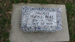
Ruth L. Killion Merz
| Birth | : | 11 Jan 1917 Albion, Boone County, Nebraska, USA |
| Death | : | 30 Jun 1999 Omaha, Douglas County, Nebraska, USA |
| Burial | : | Ramsgate Cemetery, Ramsgate, Thanet District, England |
| Coordinate | : | 51.3427270, 1.4209750 |
| Description | : | Columbus Telegram Monday August 2, 1999 Ruth Merz ALBION: Ruth Lillian Merz, 82, of Omaha, formerly of Albion, died Friday, July 30, 1999, at the University of Nebraska Medical Center in Omaha. Services are 2 p.m. Tuesday at Levander Funeral Home in Albion with the Rev. Brian Bergum officiating. Burial is at Rose Hill Cemetery in Albion. Visitation is 4-8 p.m. today at the funeral home. Mrs. Merz was born Jan. 11, 1917, in Albion to Roy L. and Ella (Warken) Killion. She received her elementary education at Boone County School District 52 in rural Albion. She graduated from Albion... Read More |
frequently asked questions (FAQ):
-
Where is Ruth L. Killion Merz's memorial?
Ruth L. Killion Merz's memorial is located at: Ramsgate Cemetery, Ramsgate, Thanet District, England.
-
When did Ruth L. Killion Merz death?
Ruth L. Killion Merz death on 30 Jun 1999 in Omaha, Douglas County, Nebraska, USA
-
Where are the coordinates of the Ruth L. Killion Merz's memorial?
Latitude: 51.3427270
Longitude: 1.4209750
Family Members:
Parent

Spouse
Siblings
Flowers:


Nearby Cemetories:
1. Ramsgate Cemetery
Ramsgate, Thanet District, England
Coordinate: 51.3427270, 1.4209750
2. St. George's Churchyard
Ramsgate, Thanet District, England
Coordinate: 51.3360951, 1.4179783
3. St Laurence Churchyard
St Lawrence, Thanet District, England
Coordinate: 51.3377140, 1.4009720
4. St. Augustine Roman Catholic Churchyard
Ramsgate, Thanet District, England
Coordinate: 51.3282920, 1.4101230
5. Baptist Church Cemetery
St Peters, Thanet District, England
Coordinate: 51.3648280, 1.4186530
6. St. Peter the Apostle Churchyard
St Peters, Thanet District, England
Coordinate: 51.3650400, 1.4190700
7. Margate Cemetery
Margate, Thanet District, England
Coordinate: 51.3739880, 1.3762730
8. Thanet Crematorium
Margate, Thanet District, England
Coordinate: 51.3745290, 1.3765230
9. St John the Baptist Church
Margate, Thanet District, England
Coordinate: 51.3837680, 1.3832260
10. Trinity Square War Memorials
Margate, Thanet District, England
Coordinate: 51.3902090, 1.3851790
11. Minster Cemetery
Minster-in-Thanet, Thanet District, England
Coordinate: 51.3423100, 1.3160550
12. St Mary the Virgin Church
Minster-in-Thanet, Thanet District, England
Coordinate: 51.3305810, 1.3156720
13. All Saints Churchyard
Birchington, Thanet District, England
Coordinate: 51.3736580, 1.3059360
14. St .Mary's Churchyard
Sandwich, Dover District, England
Coordinate: 51.2771930, 1.3386580
15. St. Peter's Churchyard
Sandwich, Dover District, England
Coordinate: 51.2747680, 1.3405120
16. St Clement's Church
Sandwich, Dover District, England
Coordinate: 51.2736510, 1.3427270
17. St Nicholas-at-Wade Cemetery
St Nicholas at Wade, Thanet District, England
Coordinate: 51.3578344, 1.2534168
18. St. Nicholas' Churchyard
St Nicholas at Wade, Thanet District, England
Coordinate: 51.3542160, 1.2517980
19. Saint Mary The Virgin Churchyard
Woodnesborough, Dover District, England
Coordinate: 51.2628240, 1.3073810
20. St. Nicholas Churchyard
Ash, Dover District, England
Coordinate: 51.2786800, 1.2786400
21. Church of Saint George at Ham
Eastry, Dover District, England
Coordinate: 51.2444830, 1.3319350
22. Deal Congregational Church
Deal, Dover District, England
Coordinate: 51.2264163, 1.4024282
23. All Saints Churchyard
Stourmouth, Dover District, England
Coordinate: 51.3202600, 1.2365520
24. St Mary the Virgin Churchyard
Eastry, Dover District, England
Coordinate: 51.2453000, 1.3100000