

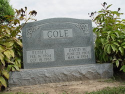
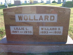
Ruth Lee Wollard Cole
| Birth | : | 16 Feb 1904 Ray County, Missouri, USA |
| Death | : | 18 Oct 1983 Richmond, Ray County, Missouri, USA |
| Burial | : | Sierra View Memorial Park, Olivehurst, Yuba County, USA |
| Coordinate | : | 39.0872002, -121.5363998 |
| Description | : | RICHMOND - Mrs. Ruth L. Cole, 79, Richmond, died Tuesday in a nursing home here. She was a lifelong Ray County, Mo., resident. Mrs. Cole had been a teacher in rural Ray County schools. She was a member of the New Hope United Methodist Church, near Hardin, Mo. She leaves her husband, David M. Cole, of the home, and two sisters, Mrs. Nettie Linville, Kansas City, and Mrs. Mary June Coats, Braymer, Mo. Services will be at 1:30 p.m. Friday at the church; burial in the church cemetery. Friends may call from 7 to... Read More |
frequently asked questions (FAQ):
-
Where is Ruth Lee Wollard Cole's memorial?
Ruth Lee Wollard Cole's memorial is located at: Sierra View Memorial Park, Olivehurst, Yuba County, USA.
-
When did Ruth Lee Wollard Cole death?
Ruth Lee Wollard Cole death on 18 Oct 1983 in Richmond, Ray County, Missouri, USA
-
Where are the coordinates of the Ruth Lee Wollard Cole's memorial?
Latitude: 39.0872002
Longitude: -121.5363998
Family Members:
Parent

Spouse
Siblings
Flowers:


Nearby Cemetories:
1. Sierra View Memorial Park
Olivehurst, Yuba County, USA
Coordinate: 39.0872002, -121.5363998
2. Yuba City Cemetery
Yuba City, Sutter County, USA
Coordinate: 39.1366010, -121.6128270
3. Sutter-Yuba Memorial Park
Yuba City, Sutter County, USA
Coordinate: 39.1384080, -121.6123760
4. Praise Chapel Mausoleum
Yuba City, Sutter County, USA
Coordinate: 39.1383610, -121.6127890
5. Saint Joseph Catholic Cemetery
Marysville, Yuba County, USA
Coordinate: 39.1591310, -121.5908240
6. Marysville Jewish Cemetery
Marysville, Yuba County, USA
Coordinate: 39.1615300, -121.5879100
7. Marysville Cemetery
Marysville, Yuba County, USA
Coordinate: 39.1621367, -121.5889756
8. Wheatland Cemetery
Wheatland, Yuba County, USA
Coordinate: 39.0083008, -121.4360962
9. Lofton Cemetery
Yuba County, USA
Coordinate: 39.0783005, -121.3696976
10. Fairview Cemetery
Rio Oso, Sutter County, USA
Coordinate: 38.9389000, -121.5250015
11. Camp Far West Cemetery
Wheatland, Yuba County, USA
Coordinate: 39.0395500, -121.3431400
12. Vineyard Cemetery
Yuba County, USA
Coordinate: 39.1557900, -121.3281600
13. Browns Valley Cemetery
Browns Valley, Yuba County, USA
Coordinate: 39.2332100, -121.4079400
14. Sheridan Cemetery
Sheridan, Placer County, USA
Coordinate: 38.9741000, -121.3585300
15. Long Bar Cemetery
Brownsville, Yuba County, USA
Coordinate: 39.2234900, -121.3860400
16. Cabbage Patch Cemetery
Waldo Junction, Yuba County, USA
Coordinate: 39.1117300, -121.3066200
17. Sutter Cemetery
Sutter, Sutter County, USA
Coordinate: 39.1697006, -121.7438965
18. Nicolaus Cemetery
Nicolaus, Sutter County, USA
Coordinate: 38.8958015, -121.5639038
19. Timbuctoo Cemetery
Smartsville, Yuba County, USA
Coordinate: 39.2159925, -121.3175461
20. Androus Family Pioneer Cemetery
Iowa City, Yuba County, USA
Coordinate: 39.2936100, -121.4639800
21. McGanney Cemetery
Smartsville, Yuba County, USA
Coordinate: 39.2018100, -121.2988310
22. Smartsville Cemetery
Smartsville, Yuba County, USA
Coordinate: 39.1973500, -121.2953500
23. Immaculate Conception Cemetery
Smartsville, Yuba County, USA
Coordinate: 39.2023500, -121.2989300
24. Live Oak Cemetery
Live Oak, Sutter County, USA
Coordinate: 39.2768784, -121.6790924