
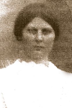
Sallie Florence Pate Nolen
| Birth | : | 3 Mar 1891 |
| Death | : | 8 May 1963 |
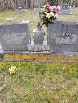
| Burial | : | St. Mary Magdalene Church, Newark-on-Trent, Newark and Sherwood District, England |
| Coordinate | : | 53.0766983, -0.8085000 |
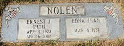
| Inscription | : | Father / Floyd D. / Mar. 23, 1891 / Sept. 11, 1963 // Mother / Sallie F. / Mar. 3, 1891 / May 8, 1963 // NOLEN |
frequently asked questions (FAQ):
-
Where is Sallie Florence Pate Nolen's memorial?
Sallie Florence Pate Nolen's memorial is located at: St. Mary Magdalene Church, Newark-on-Trent, Newark and Sherwood District, England.
-
When did Sallie Florence Pate Nolen death?
Sallie Florence Pate Nolen death on 8 May 1963 in
-
Where are the coordinates of the Sallie Florence Pate Nolen's memorial?
Latitude: 53.0766983
Longitude: -0.8085000
Family Members:
Spouse
Children
Flowers:


Nearby Cemetories:
1. St. Mary Magdalene Church
Newark-on-Trent, Newark and Sherwood District, England
Coordinate: 53.0766983, -0.8085000
2. Newark-on-Trent Cemetery
Newark-on-Trent, Newark and Sherwood District, England
Coordinate: 53.0692040, -0.7988660
3. All Saints Churchyard
Winthorpe, Newark and Sherwood District, England
Coordinate: 53.0983646, -0.7884366
4. Balderton Cemetery
Balderton, Newark and Sherwood District, England
Coordinate: 53.0539100, -0.7877400
5. St Wilfrid's Churchyard
Kelham, Newark and Sherwood District, England
Coordinate: 53.0901100, -0.8459700
6. Balderton Methodist Church
Newark-on-Trent, Newark and Sherwood District, England
Coordinate: 53.0551620, -0.7823410
7. All Saints Churchyard
Hawton, Newark and Sherwood District, England
Coordinate: 53.0513890, -0.8258330
8. St Giles Churchyard
Balderton, Newark and Sherwood District, England
Coordinate: 53.0553010, -0.7780750
9. St. Michael's Churchyard
Averham, Newark and Sherwood District, England
Coordinate: 53.0810080, -0.8549840
10. Farndon Municipal Cemetery
Farndon, Newark and Sherwood District, England
Coordinate: 53.0606540, -0.8487310
11. St Wilfred Churchyard
South Muskham, Newark and Sherwood District, England
Coordinate: 53.1071300, -0.8156400
12. St Laurence Churchyard
Thorpe, Newark and Sherwood District, England
Coordinate: 53.0428100, -0.8575900
13. St Bartholomew Churchyard
Langford, Newark and Sherwood District, England
Coordinate: 53.1225760, -0.7743940
14. Holy Trinity Churchyard
Rolleston, Newark and Sherwood District, England
Coordinate: 53.0646500, -0.8944500
15. St Peter & St Paul's Churchyard
Upton, Newark and Sherwood District, England
Coordinate: 53.0805800, -0.9014900
16. St Michael's Churchyard
Cotham, Newark and Sherwood District, England
Coordinate: 53.0199600, -0.8174700
17. St Oswald Churchyard
East Stoke, Newark and Sherwood District, England
Coordinate: 53.0427727, -0.8860863
18. All Saints Churchyard
Elston, Newark and Sherwood District, England
Coordinate: 53.0237280, -0.8701810
19. St Giles Churchyard
Cromwell, Newark and Sherwood District, England
Coordinate: 53.1449750, -0.8063850
20. All Saints Churchyard
Beckingham, North Kesteven District, England
Coordinate: 53.0740990, -0.6945420
21. St Denis Churchyard
Morton, Newark and Sherwood District, England
Coordinate: 53.0545100, -0.9168100
22. St. John the Baptist Churchyard
Collingham, Newark and Sherwood District, England
Coordinate: 53.1425550, -0.7656640
23. St Andrew Churchyard
Caunton, Newark and Sherwood District, England
Coordinate: 53.1322090, -0.8869640
24. St. Laurence Churchyard
Norwell, Newark and Sherwood District, England
Coordinate: 53.1474220, -0.8418600