
| Birth | : | 8 Sep 1922 Wagener, Aiken County, South Carolina, USA |
| Death | : | 18 Jun 2005 Orangeburg, Orangeburg County, South Carolina, USA |
| Burial | : | Barnston Cemetery, Barnston, Metropolitan Borough of Wirral, England |
| Coordinate | : | 53.3408590, -3.0820730 |
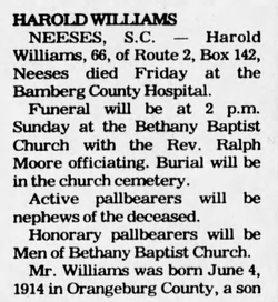
| Description | : | Orangeburg - Sam Williams, 82, of 133 Samshop Road, Orangeburg, died Saturday, June 18, 2005, at The Regional Medical Center in Orangeburg. Graveside services will be held at 3 p.m. Tuesday, June 21, in Memorial Park Cemetery in Orangeburg, with the Rev. Larry Williams officiating. Mr. Williams was born in Wagener, a son of the late Wade Hampton Williams and the late Lessie Cooper Williams. He was a retired owner and operator of Sams Auto-Body Repair Shop in Orangeburg. He was a member of Rivelon Baptist Church and the Adult I Sunday School Class. He was an Army veteran of... Read More |
frequently asked questions (FAQ):
-
Where is Sam Williams's memorial?
Sam Williams's memorial is located at: Barnston Cemetery, Barnston, Metropolitan Borough of Wirral, England.
-
When did Sam Williams death?
Sam Williams death on 18 Jun 2005 in Orangeburg, Orangeburg County, South Carolina, USA
-
Where are the coordinates of the Sam Williams's memorial?
Latitude: 53.3408590
Longitude: -3.0820730
Family Members:
Parent
Spouse

Siblings
Children
Flowers:


Nearby Cemetories:
1. Barnston Cemetery
Barnston, Metropolitan Borough of Wirral, England
Coordinate: 53.3408590, -3.0820730
2. Heswall Cemetery
Heswall, Metropolitan Borough of Wirral, England
Coordinate: 53.3400420, -3.1102790
3. St Peter's Churchyard
Heswall, Metropolitan Borough of Wirral, England
Coordinate: 53.3227400, -3.1036400
4. Landican Cemetery and Crematorium
Woodchurch, Metropolitan Borough of Wirral, England
Coordinate: 53.3654000, -3.0887510
5. All Saints Churchyard
Thornton Hough, Metropolitan Borough of Wirral, England
Coordinate: 53.3203500, -3.0444780
6. St Bartholomew's Churchyard
Thurstaston, Metropolitan Borough of Wirral, England
Coordinate: 53.3485750, -3.1320070
7. Holy Cross Churchyard
Woodchurch, Metropolitan Borough of Wirral, England
Coordinate: 53.3731900, -3.0899400
8. Christ Church
Bebington, Metropolitan Borough of Wirral, England
Coordinate: 53.3584460, -3.0254810
9. Salacre Lane Cemetery
Upton, Metropolitan Borough of Wirral, England
Coordinate: 53.3824050, -3.0919920
10. Bebington Cemetery
Bebington, Metropolitan Borough of Wirral, England
Coordinate: 53.3588030, -3.0165370
11. Saint Mary's Churchyard
Upton, Metropolitan Borough of Wirral, England
Coordinate: 53.3847010, -3.0961600
12. St. John the Divine
Frankby, Metropolitan Borough of Wirral, England
Coordinate: 53.3744200, -3.1330200
13. Frankby Cemetery
Frankby, Metropolitan Borough of Wirral, England
Coordinate: 53.3715920, -3.1399600
14. St Andrews Parish Churchyard
Bebington, Metropolitan Borough of Wirral, England
Coordinate: 53.3479800, -3.0035400
15. Neston Cemetery
Neston, Cheshire West and Chester Unitary Authority, England
Coordinate: 53.2943100, -3.0571400
16. St Paul's
Tranmere, Metropolitan Borough of Wirral, England
Coordinate: 53.3740000, -3.0154600
17. St Mary and St Helen Neston
Neston, Cheshire West and Chester Unitary Authority, England
Coordinate: 53.2892600, -3.0640600
18. Christ Church Churchyard
Port Sunlight, Metropolitan Borough of Wirral, England
Coordinate: 53.3534920, -2.9953750
19. St. Peter's Churchyard
Bebington, Metropolitan Borough of Wirral, England
Coordinate: 53.3692500, -3.0021020
20. Flaybrick Memorial Gardens
Birkenhead, Metropolitan Borough of Wirral, England
Coordinate: 53.3968130, -3.0633240
21. Saint Winefride Churchyard
Little Neston, Cheshire West and Chester Unitary Authority, England
Coordinate: 53.2849200, -3.0592100
22. St. Werburgh & St. Laurence Catholic Churchyard
Birkenhead, Metropolitan Borough of Wirral, England
Coordinate: 53.3894910, -3.0217530
23. Christ Church Churchyard
Moreton, Metropolitan Borough of Wirral, England
Coordinate: 53.3999580, -3.1112310
24. Grange Cemetery
West Kirby, Metropolitan Borough of Wirral, England
Coordinate: 53.3751630, -3.1682120