
| Birth | : | 2 Dec 1874 Smith County, Kansas, USA |
| Death | : | 23 Dec 1950 Topeka, Shawnee County, Kansas, USA |
| Burial | : | Netawaka Cemetery, Netawaka, Jackson County, USA |
| Coordinate | : | 39.6075300, -95.7223700 |
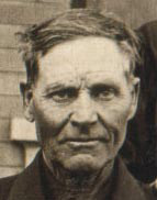
| Description | : | Ed served in Co. D, 22nd Kansas Volunteer Infantry Spanish American War. He married Amelia Askew Woodall at Hiawatha, Kansas on August 20, 1902. They lived in Jackson and Nemaha Counties, Kansas. Their children were: Dorothy Myers Monaghan Delpha Myers Brammer Jorden Harald Myers Will Myers Charles Myers Ed died at the Winter General (VA) Hospital in Topeka, Kansas |
frequently asked questions (FAQ):
-
Where is Samuel Edwin “Ed” Myers's memorial?
Samuel Edwin “Ed” Myers's memorial is located at: Netawaka Cemetery, Netawaka, Jackson County, USA.
-
When did Samuel Edwin “Ed” Myers death?
Samuel Edwin “Ed” Myers death on 23 Dec 1950 in Topeka, Shawnee County, Kansas, USA
-
Where are the coordinates of the Samuel Edwin “Ed” Myers's memorial?
Latitude: 39.6075300
Longitude: -95.7223700
Family Members:
Parent
Spouse

Siblings
Children
Flowers:


Nearby Cemetories:
1. Netawaka Cemetery
Netawaka, Jackson County, USA
Coordinate: 39.6075300, -95.7223700
2. Pleasant Grove Cemetery
Jackson County, USA
Coordinate: 39.5664000, -95.7789000
3. South Powhattan Cemetery
Powhattan, Brown County, USA
Coordinate: 39.6608009, -95.7596970
4. Wetmore Cemetery
Wetmore, Nemaha County, USA
Coordinate: 39.6396800, -95.8108400
5. Grant-Mjessepe Cemetery
Horton, Brown County, USA
Coordinate: 39.6663000, -95.6576000
6. Spring Hill Cemetery
Whiting, Jackson County, USA
Coordinate: 39.6021996, -95.6121979
7. Jessepe Indian Cemetery
Horton, Brown County, USA
Coordinate: 39.6715000, -95.6438000
8. Kennekuk Church Cemetery
Horton, Brown County, USA
Coordinate: 39.7074600, -95.6672300
9. Estes Cemetery
Jackson County, USA
Coordinate: 39.5346985, -95.6168976
10. Wolfley Cemetery
Goff, Nemaha County, USA
Coordinate: 39.6454400, -95.8633900
11. Carmel Cemetery
Circleville, Jackson County, USA
Coordinate: 39.4984400, -95.7967700
12. Wheatland Cemetery
Atchison County, USA
Coordinate: 39.6453018, -95.5633011
13. Ontario Cemetery
Nemaha County, USA
Coordinate: 39.5663795, -95.8885193
14. Wyant Family Cemetery
Holton, Jackson County, USA
Coordinate: 39.4778520, -95.6614440
15. Granada Cemetery
Granada, Nemaha County, USA
Coordinate: 39.7324982, -95.7988968
16. Thompson-Burns Cemetery
Whiting, Jackson County, USA
Coordinate: 39.5062100, -95.5980710
17. Mount Calvary Catholic Cemetery
Holton, Jackson County, USA
Coordinate: 39.4700012, -95.7702026
18. Bradley Family Cemetery
Holton, Jackson County, USA
Coordinate: 39.4644928, -95.6813889
19. Comet Cemetery
Powhattan Township, Brown County, USA
Coordinate: 39.7542600, -95.7340400
20. Holton Cemetery
Holton, Jackson County, USA
Coordinate: 39.4611015, -95.7583008
21. Saint Peters Cemetery
Mercier, Brown County, USA
Coordinate: 39.7247009, -95.6016998
22. Lutheran Cemetery
Mercier, Brown County, USA
Coordinate: 39.7250500, -95.6000710
23. Grasshopper Burial Ground
Powhattan Township, Brown County, USA
Coordinate: 39.7578020, -95.6949820
24. Barnes Cemetery
Goff, Nemaha County, USA
Coordinate: 39.6960983, -95.8824997