| Description |
: |
Sarah's parents were:
William Lunceford, b. Apr. 15, 1796 in Sugarloaf Heights, St. Clair County, IL. and d. Sep. 6, 1876 in San Luis Obispo, San Luis Obispo County, CA. &
Mary Elizabeth Trent, b. Feb. 8, 1803 in Hawkins County, TN. and d. Nov. 5, 1873 in San Luis Obispo, San Luis Obispo County, CA.
(*Note: Mary Elizabeth Trent married first, Married Timothy Holdaway, about 1819, in Hawkins, TN. Sometime after Timothy died, she married second, William Henry Lunceford on Nov. 8, 1837 in St. Clair, IL.)
In the 1850 U....
Read More
|
Sarah's parents were:
William Lunceford, b. Apr. 15, 1796 in Sugarloaf Heights, St. Clair County, IL. and d. Sep. 6, 1876 in San Luis Obispo, San Luis Obispo County, CA. &
Mary Elizabeth Trent, b. Feb. 8, 1803 in Hawkins County, TN. and d. Nov. 5, 1873 in San Luis Obispo, San Luis Obispo County, CA.
(*Note: Mary Elizabeth Trent married first, Married Timothy Holdaway, about 1819, in Hawkins, TN. Sometime after Timothy died, she married second, William Henry Lunceford on Nov. 8, 1837 in St. Clair, IL.)
In the 1850 U. S. census, 6 yr. old Sarah Lunesford (Lunceford), b. in St. Clair county, IL., was living in District 3, St Clair, IL. with her
54 yr. old (inferred) father, William Lunesford (Lunceford)doing farming, b. in St. Clair county, IL.
47 yr. old (inferred) mother, Mary Lunesford (Lunceford), b. in TN.
12 yr. old (inferred) brother, William Lunesford (Lunceford), b. in St. Clair county, IL.
9 yr. old (inferred) sister, Emiline Lunesford (Lunceford), b. in St. Clair county, IL.
2 yr. old (inferred) sister, Syntha Lunesford (Lunceford), b. in St. Clair county, IL.
17 yr. old Marion Outhouse, a (male) laborer, b. in IL.
William's real estate was valued at $4,000.
In the 1860 U. S. census, 16 yr. old Sarah Lunceford, b. in IL., was attending school and living in San Salvador (near Colton), San Bernardino county, CA. with her
64 yr. old (inferred) father, Wm. Lunceford, a farmer, b. in IL.
57 yr. old (inferred) mother, Mary Lunceford, b. in TN.
12 yr. old (inferred) sister, Cynthia Lunceford, attending school, b. in IL.
William's real estate was valued at $800 and his personal property at $300.
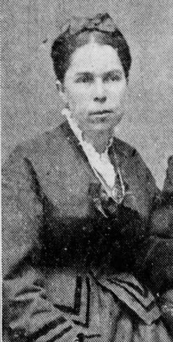
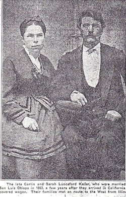
On Mar. 29, 1863, William Carlin Keller and Sarah Melvina Lunceford were married in San Luis Obispo county, CA.
William and Sarah Keller's children were:
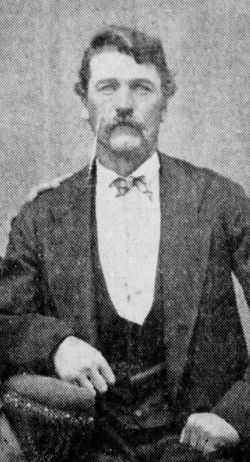
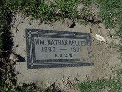
1. William Nathan Keller, b. Dec. 22 (or 29), 1863 in San Bernardino, San Bernardino County, CA. and d. May 12, 1930 in San Bernardino County, CA. William marr. Mary Elizabeth Heap.
2. George David Keller, b. May 17, 1866 in San Bernardino, San Bernardino County, CA. and d. Jan. 31, 1896 at the age of 29 in San Bernardino, San Bernardino County, CA. George marr. Lucy Elkins.
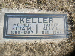
3. Ally Carlin Keller, b. Jul. 26, 1868 in San Bernardino, San Bernardino county, CA. and d. Dec. 28, 1942 in San Bernardino, San Bernardino county, CA. Ally marr. Hannah Rachel Sawyer in 1881 and second, Henrietta "Etta" (Hattery) Melton.
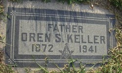
4. Oren/Orin Samuel Keller, b. Mar. 17, 1872 in San Bernardino, San Bernardino county, CA. and d. Dec. 26, 1941 in San Bernardino, San Bernardino county, CA. Oren marr. Mary Cunning.
5. Arden Hyram Keller, b. Oct. 6, 1874 in San Bernardino, San Bernardino county, CA. and d. Sep. 9, 1912 in San Bernardino, San Bernardino county, CA. Arden marr. Lucy Purcell.
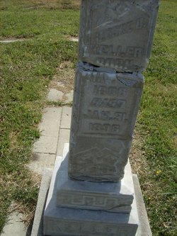
6. Sarah D. Keller (twin), b. May 8, 1882 in San Bernardino, San Bernardino county, CA. and d. Mar. 21, 1884 in San Bernardino county, CA.
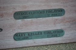
7. Mary M. Edna Keller (twin), b. May 8, 1882 in San Bernardino, San Bernardino county, CA. and d. Aug. 10, 1950 in Orange county, CA. Edna/Mary marr. Ornie/Jack P. Ward in 1900 and George Clifford Finlayson.
In the 1870 U. S. census, 26 yr. old Sarah Keller, keeping house, b. in IL., was living in San Bernardino, San Bernardino county, CA. with her
28 yr. old (inferred) husband, William Keller, a farmer, b. in OH.
6 yr. old (inferred) son, William Keller, attending school, b. in CA.
4 yr. old (inferred) son, George Keller, b. in CA.
1 yr. old (inferred) daughter, Caroline Keller, b. in CA. (*son, Carlin)
William's real estate was valued at $1,500 and his personal estate at $200.
In the 1880 U. S. census, 36 yr. old Sarah Ann Keller, keeping house, b. in IL., was living at 25 8th St. in San Bernardino, San Bernardino, CA. with her
38 yr. old husband, William C. Keller, a farmer, b. in IL.
16 yr. old son, William N. Keller, b. in CA.
14 yr. old son, George D. Keller, b. in CA.
11 yr. old son, Ally C. Keller, b. in CA.
8 yr. old son, Oren C. Keller, b. in CA.
5 yr. old son, Ardent H. Keller, b. in CA.
48 yr. old brother-in-law, Saml. Luncford, a herder, b. in IL.
William's father was b. in PA. and his mother in IL.
In the 1900 U. S. census, 56 yr. old Sarah M Keller, b. Feb. 1844 in IL., was living in a home she (and her husband) owned free and clear at 104 4th St. on the north side, in San Bernardino Ward 2, San Bernardino, CA. with her
58 yr. old husband, William C. Keller, a farmer, b. Apr. 1842 in IL.
18 yr. old married daughter, Edna Ward, b. May 1882 in CA.
21 yr. old son-in-law, Ornie Ward, a common laborer, b. Jun. 1879 in OH.
William and Sarah had been married for 37 years.
Sarah was the mother of 7 children, only 5 still alive by this census.
Edna and Ornie had been married for only 3 months.
William's father was b. in PA. and his mother in IL.
William had been unemployed for 12 months.
In the 1910 U. S. census, 66 yr. old Sara M Keller, b. in IL., was living in a home she (and her husband) owned free and clear at 104 Fourth St. in San Bernardino Ward 2, San Bernardino, CA. with her
68 yr. old husband, William C. Keller, a retired farmer, b. in IL.
41 yr. old widowed son, Allie C Keller, a forest ranger in a forest reserve, b. in CA.
35 yr. old divorced son, Arden H Keller, a laborer doing odd jobs, b. in CA.
8 yr. old grandson, George C Ward, b. in CA.
This was a first marriage for William and Sara. They had been married for 47 years.
Sara was the mother of 7 children, only 5 still alive by this census.
William's father was b. in NC. and his mother's birthplace was unknown.
Sara's father's birthplace was unknown but her mother was b. in UT.
George's father's birthplace was unknown but his mother was b. in CA.
San Bernardino Daily Sun (San Bernardino, CA.), P.6, Col. 2
Tue., Apr. 1, 1913
Item from: Social Happenings
Golden Wedding Anniversary Kept -
The golden wedding anniversary of a pioneer couple of San Bernardino was kept on Sunday, being made a very happy occasion for the members of the family and friends of Mr. and Mrs. W. C. Keller, who gathered at their home, 104 East Fourth street.
A beautiful decorative arrangement was given the home, the color of the anniversary being attractively prominent. Long sprays of the yellow Banksia rose were gracefully placed and bowls of daffodils added their vivid color. In the dining room a canopy of yellow was completed in the center with a depending (deepening?) cluster of orange blossoms. More daffodils brightened the table, across which bands of yellow ribbon were laid flat.
Four generations were represented among the family guests of the golden wedding couple, their son, W. N. Keller, his daughter, Mrs. Ned L. Godbey, of Bakersfield, and little Margret Godbey. Pictures were made of this group and of the entire company during the afternoon.
A family dinner was served at noon and in the afternoon a large company of friends, including many members of the Pioneer society, called, being received by Mr. and Mrs. Keller, senior, Mr. and Mrs. W. N. Keller and Mr. and Mrs. A. C. Keller. A register was kept of the guests as an interesting souvenir of the occasion. Refreshments were served from the pleasing table in the dining room with its golden tone.
The romance of the golden wedding couple began when they were schoolmates in San Bernardino, and the girl sweetheart was, when she answered to her full name, Sarah Melvina Lunceford. Soon the sweetheart schoolmate was whisked away with her family to a home near San Luis Obispo. In two years, however, the San Bernardino swain departed on a horseback trip to the middle of the state, with the intent of bringing home a bride.
In those days ministers were not always at hand for the marrying of lovers. In this instance, a 12-mile ride was undertaken in search of a justice of the peace to perform the ceremony. The prospective bride and groom, the bride's sister, and neighboring friends, started on the pre-wedding trip.
The personage sought was away from home, but luck was with the lovers, and the party met him in the public highway as they turned back in disappointment. Forthwith the bridal group was formed, with a live oak forming a leafy wedding bower, and the knot, which has endured happily through 50 years of married life, was tied.
The young couple remained near San Luis Obispo until November, when they started for San Bernardino, driving down, the trip taking 10 days.
They lived at the Keller home place in Base Line until the house was lost by fire, when they moved to East Fourth street, which has since been their home.
Of Mr. and Mrs. Keller's children, five sons and two daughters, four are living, W. N. Keller, A. C. Keller, O. S. Keller of Rialto; Mrs. E. C. Finlayson, of Huntington Beach.
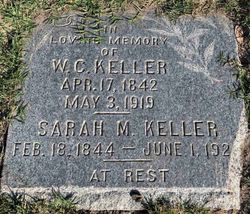
On May 3, 1919, Sarah's husband, William Carlin Keller, died at the age of 77 in San Bernardino, San Bernardino County, CA.
In the Jan. 5, 1920 U. S. census, 75 yr. old widow, Sara L Keller, b. in IL., was living alone in a home she owned free and clear at 114 Fourth St. in San Bernardino, San Bernardino, CA.
Sara's father was b. in IL. and her mother in TN.
San Bernardino Daily Sun (San Bernardino, CA.), P. 5, Col. 4
Tue., Aug. 17, 1920
Leaves to Make Her Home In Colorado
Mrs. Sarah Lunceford Keller of East Fourth Street will leave tomorrow for Delta, Colo., to make her home with her daughter Mrs. G. C. Finlayson and Mr. Finlayson. Mrs. Keller is a pioneer resident, and her good friends will follow her with good wishes to her new home, where she expects to be very happy.
San Bernardino Daily Sun (San Bernardino, CA.), P. 5, Col. 1
Wed., Dec. 28, 1921
Family Reunion Marks Holiday At W. N. (William Nathan) Keller Home
The Christmas season was marked by a happy family reunion at the home of Mr. and Mrs. W. N. Keller at 222 Seventh Street, with Grandma Sarah Lunceford Keller as the chief guest of honor at the gathering of children, grandchildren and great-grandchildren.
Early on Christmas day there was the lighting of a beautiful Christmas tree with gay decorations and remembrances for all. The turkey feast was an elaborate one, and the afternoon was passed in visiting, looking backward over happy Christmas celebrations and enjoyment of music on the Brunswick.
Those having a part in the delightful reunion day of the Yuletide were Mr. and Mrs. Clifford Finlayson and son George of Huntington Beach, the latter on leave from the U. S. S. Connecticut; Mrs. Sarah Lunceford Keller, Mr. and Mrs. A. C. Keller, Mr. and Mrs. Orin Keller and children, May and Harry; Margaret Anderson, Mr. and Mrs. W. N. Keller and son, Fred Keller.
San Bernardino Daily Sun (San Bernardino, CA.), P. 3, Col. 4
Fri., Jun. 2, 1922
MRS. SARAH LUNCEFORD KELLER.
Mrs. Sarah Lunceford Keller, one of the best loved pioneer women of this city, died at her home, 104 Fourth Street, yesterday morning at 5 o'clock. Mrs. Keller had been ill since the middle of February, and although her loved ones knew that the end was near, yet they were loath to say goodbye for she was a favorite among them all, her four children, her 12 grandchildren and her three great-grandchildren always happy to be in her company.
Mrs. Keller was 78 years of age, having been born in St. Claire County, Illinois. She came to California when seven years old and had been a resident of San Bernardino for the past 59 years, coming here in 1863. She was a constant attendant at the meetings of the Pioneer Society and liked nothing better than to talk over old times with her friends, and always an active participant in the festivities of the society. Outside of her home she will perhaps be missed among the pioneers more than anywhere else.
The husband of Mrs. Keller, William C. Keller, passed away in 1919. There were born to the union five sons and two daughters, two sons and one daughter having passed away some years ago.
There survive three sons, A. C. Keller, O. S. Keller and W. N. Keller and
one daughter, Mrs. Mary Keller Finlayson, all of this city;
12 grandchildren, Fred Keller of San Bernardino, Mrs. Barbara Anderson, Mrs. Mayme Armstrong, Carl Keller of Inyo County, Chris Keller of Long Beach, Glenn Keller of Arrowhead Hospital; Clyde, George, Harry, Forest and Mary Keller of San Bernardino, and George Finlayson, on board the U. S. S. Frederic;
three great-grandchildren, Margaret, Alan and Dorothy Anderson;
a brother, William Lunceford of Gardena; and a sister, Mrs. Cynthia Lewis of Santa Cruz.
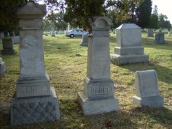
Funeral service will be held on Saturday afternoon at 2 o'clock from the chapel of the Mark B. Shaw Company, and interment will be in the Pioneer Cemetery.
San Bernardino Daily Sun (San Bernardino, CA.), P. 4, Col. 7
Sun., Jun. 4, 1922
SARAH LUNCEFORD KELLER
Funeral services for Mrs. Sarah Lunceford Keller were conducted yesterday afternoon, at 2 o'clock, in the chapel of the Mark B. Shaw company, by the Rev. R. M. Dungan of the First Christian Church, and by the officers of the Society of Pioneers, of which Mrs. Lunceford had been a constant member for many years.
Mrs. A. W. Bates and George Merriam sang solos, "Sometime We'll Understand" and "Beautiful Isle of Somewhere."
Pallbearers were Fred Keller, George Finlayson, George Keller, Glenn Keller, Clyde Keller and Chris Keller, all grandchildren of Mrs. Keller.
Burial was in the Pioneer Cemetery by the Mark B. Shaw Company.
San Bernardino Daily Sun (San Bernardino, CA.), P. 5, Col. 3
Mon., Jun. 5, 1922
Excerpts from: Doings of the Pioneers
The Pioneers attended the funeral of Mrs. Sarah Lunceford Keller at two o'clock Saturday afternoon in a body, having postponed the meeting until three o'clock. Grandma Keller was a faithful attendant at the Pioneer meetings and was one of the sturdy band of Pioneers who knew the ox-team and its frontier hardships.
The sympathy of the society was sent to the relatives of Sarah Lunceford Keller and Mrs. McKittrick, mother of Mrs. Mollie Case.
San Bernardino Daily Sun (San Bernardino, CA.), P. 2, Col. 3
Sun., Jun. 4, 1922
CARD OF THANKS
We wish to express our deepest appreciation for the kindness shown us by neighbors and friends during the illness and at the death of our beloved mother, Mrs. Sarah Lunceford Keller, also for the beautiful flowers sent in memoriam.
W. N. KELLER AND FAMILY.
A. C. KELLER AND FAMILY.
O. S. KELLER AND FAMILY.
MR. AND MRS. G. C. FINLAYSON AND FAMILY. |