Sarah Stultz Dodd
| Birth | : | 27 Mar 1817 Stokes County, North Carolina, USA |
| Death | : | 7 Sep 1890 |
| Burial | : | Opunake Cemetery, Opunake, South Taranaki District, New Zealand |
| Coordinate | : | -39.4515370, 173.8458110 |
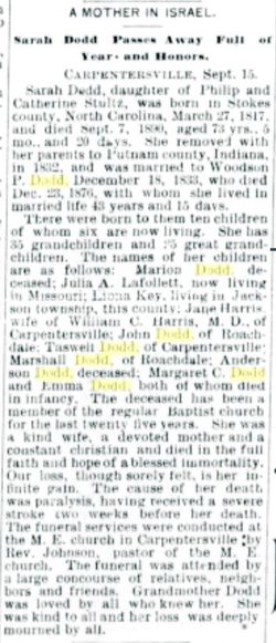
| Description | : | Wife of W. P. Dodd Dodd, Sarah, P.O. Carpentersville, residence, Section 26; born March 27, 1817, in Stokes County, N.C.; daughter of Philip Stultz, born in Stokes County, N.C., died 1841, and Catherine Ketner-Stultz, born in same county, same State, died about 1864, who settled in this county in 1832, on Section 33 of this township. She was married December 18, 1833, in this township [Franklin], to Woodson P. Dodd, the son of John and Mary Dodd, natives of Franklin County, Va., where their son Woodson was born December 9, 1808. Mr. Dodd came... Read More |
frequently asked questions (FAQ):
-
Where is Sarah Stultz Dodd's memorial?
Sarah Stultz Dodd's memorial is located at: Opunake Cemetery, Opunake, South Taranaki District, New Zealand.
-
When did Sarah Stultz Dodd death?
Sarah Stultz Dodd death on 7 Sep 1890 in
-
Where are the coordinates of the Sarah Stultz Dodd's memorial?
Latitude: -39.4515370
Longitude: 173.8458110
Family Members:
Parent
Spouse
Siblings
Children
Nearby Cemetories:
1. Opunake Cemetery
Opunake, South Taranaki District, New Zealand
Coordinate: -39.4515370, 173.8458110
2. Pihama Cemetery
Pihama, South Taranaki District, New Zealand
Coordinate: -39.5075300, 173.9285600
3. Rahotu Cemetery
Rahotu, South Taranaki District, New Zealand
Coordinate: -39.3339080, 173.7992810
4. Otakeho Cemetery
New Plymouth, New Plymouth District, New Zealand
Coordinate: -39.5492080, 174.0051880
5. Parihaka Pā Urupa
Parihaka Pa, South Taranaki District, New Zealand
Coordinate: -39.2897366, 173.8370149
6. Kaponga Cemetery
Kaponga, South Taranaki District, New Zealand
Coordinate: -39.4312210, 174.1553160
7. Manaia Redoubt
Manaia, South Taranaki District, New Zealand
Coordinate: -39.5461557, 174.1364306
8. Motuawa Urupā Waiokura Marae
Manaia, South Taranaki District, New Zealand
Coordinate: -39.5388010, 174.1438990
9. Manaia Cemetery
Manaia, South Taranaki District, New Zealand
Coordinate: -39.5575010, 174.1354470
10. Okato Cemetery
Okato, New Plymouth District, New Zealand
Coordinate: -39.1904200, 173.8821100
11. Te Ngutu o te Manu Battlesite Memorial
Kapuni, South Taranaki District, New Zealand
Coordinate: -39.4876351, 174.1838147
12. Okaiawa Cemetery
Okaiawa, South Taranaki District, New Zealand
Coordinate: -39.5310220, 174.2042180
13. Weri Weri Urupa Aotearoa Marae
Okaiawa, South Taranaki District, New Zealand
Coordinate: -39.5190700, 174.2206700
14. Ohawe Military Cemetery
Ohawe Beach, South Taranaki District, New Zealand
Coordinate: -39.5835138, 174.2003758
15. Tataraimaka Cemetery
Oakura, New Plymouth District, New Zealand
Coordinate: -39.1503230, 173.9138870
16. Waihi Cemetery and Redoubt
Normanby, South Taranaki District, New Zealand
Coordinate: -39.5444930, 174.2566820
17. Te Utinga Urupā
Normanby, South Taranaki District, New Zealand
Coordinate: -39.5330847, 174.2761055
18. Pioneer Cemetery
Stratford, Stratford District, New Zealand
Coordinate: -39.3359800, 174.2929000
19. Midhirst Cemetery
Midhirst, Stratford District, New Zealand
Coordinate: -39.2913640, 174.2724620
20. Midhirst Old Cemetery
Midhirst, Stratford District, New Zealand
Coordinate: -39.2911920, 174.2731980
21. Eltham Cemetery
Eltham, South Taranaki District, New Zealand
Coordinate: -39.4197140, 174.3251260
22. Hāwera Cemetery
Hāwera, South Taranaki District, New Zealand
Coordinate: -39.5897900, 174.2945500
23. Waireka Cemetery
Omata, New Plymouth District, New Zealand
Coordinate: -39.0929300, 174.0087200
24. Mangapouri Cemetery
Egmont Village, New Plymouth District, New Zealand
Coordinate: -39.1347278, 174.1282396


