

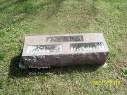
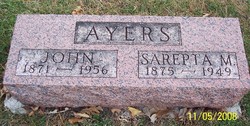
Sarepta May “Rip” Sigler Ayers
| Birth | : | 16 Dec 1875 Newton Township, Carroll County, Iowa, USA |
| Death | : | 30 Jan 1949 Carroll, Carroll County, Iowa, USA |
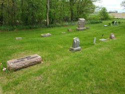
| Burial | : | Oak Hill Cemetery, Coon Rapids, Carroll County, USA |
| Coordinate | : | 41.9053001, -94.7200012 |
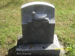
| Inscription | : | AYERS Sarepta M. 1875 ~ 1949 |
| Description | : | Sarepta May Sigler, daughter of Martin Van Buren and Polly (Knight) Sigler, was born at the family home in Newton Township, Carroll County, Iowa on December 16, 1875. She married John Henry Ayers on February 28, 1894 in Coon Rapids. With the exception of a year homesteading in Nebraska, their entire life was in farming the lands in Iowa both locally and in southern Iowa. They were the parents of ten children, five girls and five boys. She died on January 30, 1949 at the hospital in Carroll at the age of 73 years, 1 month and 14 days from... Read More |
frequently asked questions (FAQ):
-
Where is Sarepta May “Rip” Sigler Ayers's memorial?
Sarepta May “Rip” Sigler Ayers's memorial is located at: Oak Hill Cemetery, Coon Rapids, Carroll County, USA.
-
When did Sarepta May “Rip” Sigler Ayers death?
Sarepta May “Rip” Sigler Ayers death on 30 Jan 1949 in Carroll, Carroll County, Iowa, USA
-
Where are the coordinates of the Sarepta May “Rip” Sigler Ayers's memorial?
Latitude: 41.9053001
Longitude: -94.7200012
Family Members:
Parent

Spouse
Siblings
Children
Flowers:


Nearby Cemetories:
1. Oak Hill Cemetery
Coon Rapids, Carroll County, USA
Coordinate: 41.9053001, -94.7200012
2. Old Carrollton Cemetery
Carrollton, Carroll County, USA
Coordinate: 41.9233017, -94.7403030
3. Coon Rapids Cemetery
Coon Rapids, Carroll County, USA
Coordinate: 41.8778000, -94.6678009
4. McCurdy Cemetery
Carroll County, USA
Coordinate: 41.9403000, -94.7649994
5. Union Township Cemetery
Coon Rapids, Carroll County, USA
Coordinate: 41.8781013, -94.6389008
6. Saint Josephs Cemetery
Dedham, Carroll County, USA
Coordinate: 41.8993988, -94.8210983
7. Dedham Cemetery
Dedham, Carroll County, USA
Coordinate: 41.8993988, -94.8225021
8. Tuttles Grove Cemetery
Guthrie County, USA
Coordinate: 41.8130989, -94.7228012
9. Orange Township Cemetery
Guthrie County, USA
Coordinate: 41.8163986, -94.6844025
10. Viola Center Cemetery
Viola Center, Audubon County, USA
Coordinate: 41.8236008, -94.8016968
11. Saint Marys Catholic Cemetery
Willey, Carroll County, USA
Coordinate: 41.9783363, -94.8212204
12. Willow Cemetery
Greene County, USA
Coordinate: 41.9067001, -94.5730972
13. Highland Cemetery
Bayard, Guthrie County, USA
Coordinate: 41.8241997, -94.5717010
14. Elba Cemetery
Templeton, Carroll County, USA
Coordinate: 41.9068985, -94.9131012
15. West Lawn Cemetery
Glidden, Carroll County, USA
Coordinate: 42.0649986, -94.7406006
16. Scranton Township Cemetery
Scranton, Greene County, USA
Coordinate: 42.0306015, -94.5783005
17. Cameron Cemetery
Audubon County, USA
Coordinate: 41.8236008, -94.9167023
18. Union Township Cemetery
Guthrie County, USA
Coordinate: 41.7391450, -94.6858030
19. Sacred Heart Cemetery
Templeton, Carroll County, USA
Coordinate: 41.9138746, -94.9460994
20. Melville Township Cemetery
Audubon County, USA
Coordinate: 41.7439003, -94.8013992
21. Holy Angels Cemetery
Carroll County, USA
Coordinate: 42.0014000, -94.9141998
22. Luccocks Grove Cemetery
Audubon County, USA
Coordinate: 41.7619019, -94.8653030
23. Mount Olivet Cemetery
Carroll, Carroll County, USA
Coordinate: 42.0536340, -94.8595510
24. Carroll City Cemetery
Carroll, Carroll County, USA
Coordinate: 42.0560963, -94.8599856