
| Birth | : | 15 Feb 1927 Warren, Carbon County, Montana, USA |
| Death | : | 27 Sep 1964 Great Falls, Cascade County, Montana, USA |
| Burial | : | Mount Hope Cemetery, Omaha, Douglas County, USA |
| Coordinate | : | 41.3041992, -96.0310974 |
| Plot | : | Sec 1B, VET, Grave 425 |
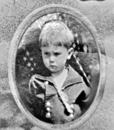
| Description | : | Owen was the second of eight children born to Maynard Solomon Jr. and Anna Caroline (Darrow) Bean. He married Kunie 'Kay' Sakamoto in 1960 and together they had three children: Roy, Ernest and Susan. Owen served in the US Air Force during WWII and the Korean War, working in undercover & top secret operations during and after the war until his death, from 1944-1964. Billings Gazette, Billings, MT 29 Sept 29 1964 Rites Friday Funeral services for T. Sgt. Sylvester O. Bean, 37, who died of a heart ailment at his home in Great... Read More |
frequently asked questions (FAQ):
-
Where is Sgt Sylvester Owen Bean's memorial?
Sgt Sylvester Owen Bean's memorial is located at: Mount Hope Cemetery, Omaha, Douglas County, USA.
-
When did Sgt Sylvester Owen Bean death?
Sgt Sylvester Owen Bean death on 27 Sep 1964 in Great Falls, Cascade County, Montana, USA
-
Where are the coordinates of the Sgt Sylvester Owen Bean's memorial?
Latitude: 41.3041992
Longitude: -96.0310974
Family Members:
Parent

Spouse
Siblings

Flowers:

Left by Anonymous on 24 May 2008

Rest in peace.
Left by Anonymous on 23 Sep 2009

Big Brother...You are missed.
Left by Anonymous on 05 Dec 2009

Left by Anonymous on 21 Dec 2011

Left by Anonymous on 09 Feb 2012

Left by Anonymous on 12 May 2012

Left by Anonymous on 03 Jun 2012

Left by Anonymous on 24 Oct 2012

Left by Anonymous on 02 Nov 2012

Left by Anonymous on 18 Dec 2012

Left by Anonymous on 01 Jan 1970

Left by Anonymous on 21 Jun 2013

Left by Anonymous on 29 Jul 2013

Left by Anonymous on 15 Feb 2014

Left by Anonymous on 27 Apr 2014

Left by Anonymous on 23 May 2014

Left by Anonymous on 01 Aug 2014

Left by Anonymous on 27 Sep 2014

Left by Anonymous on 10 Nov 2014

Left by Anonymous on 30 Dec 2014

Left by Anonymous on 16 Feb 2015

Left by Anonymous on 28 Aug 2015

Thank you for your service. Merry Christmas.
Left by Anonymous on 14 Dec 2015
Love from your little sister.
Left by Anonymous on 24 Apr 2016

Left by Anonymous on 02 Aug 2016

Left by Anonymous on 22 Aug 2016

R.I.P.
Left by Anonymous on 25 Oct 2016

Left by Anonymous on 21 Feb 2017

Left by Anonymous on 26 Oct 2017


Nearby Cemetories:
1. Mount Hope Cemetery
Omaha, Douglas County, USA
Coordinate: 41.3041992, -96.0310974
2. Servants of Mary Cemetery
Omaha, Douglas County, USA
Coordinate: 41.3017170, -96.0258260
3. Mount Sinai Cemetery
Omaha, Douglas County, USA
Coordinate: 41.3116989, -96.0314026
4. Springwell Cemetery
Omaha, Douglas County, USA
Coordinate: 41.3114014, -96.0096970
5. All Saints Episcopal Church Columbarium
Omaha, Douglas County, USA
Coordinate: 41.2785000, -96.0579000
6. Potter Field
Omaha, Douglas County, USA
Coordinate: 41.3320274, -95.9902878
7. Forest Lawn Memorial Park
Omaha, Douglas County, USA
Coordinate: 41.3272018, -95.9847031
8. Golden Hill Cemetery
Omaha, Douglas County, USA
Coordinate: 41.3050003, -95.9744034
9. Pleasant Hill Jewish Cemetery
Omaha, Douglas County, USA
Coordinate: 41.3185997, -95.9766998
10. Union Memorial Cemetery
Omaha, Douglas County, USA
Coordinate: 41.3512611, -96.0620193
11. Saint Andrews Episcopal Church Columbarium
Omaha, Douglas County, USA
Coordinate: 41.2492500, -96.0427500
12. Mormon Pioneer Cemetery
Omaha, Douglas County, USA
Coordinate: 41.3348450, -95.9663720
13. Countryside Community Church Columbarium
Omaha, Douglas County, USA
Coordinate: 41.2483660, -96.0500270
14. Nash Chapel Crypt
Omaha, Douglas County, USA
Coordinate: 41.2665090, -95.9721790
15. Holy Sepulchre Cemetery
Omaha, Douglas County, USA
Coordinate: 41.2543983, -95.9875031
16. Prospect Hill Cemetery
Omaha, Douglas County, USA
Coordinate: 41.2780991, -95.9593964
17. Ak-Sar-Ben Racetrack Grounds
Omaha, Douglas County, USA
Coordinate: 41.2414703, -96.0159607
18. Evergreen Memorial Park Cemetery
Omaha, Douglas County, USA
Coordinate: 41.2393990, -96.0355988
19. Calvary Cemetery
Omaha, Douglas County, USA
Coordinate: 41.2364006, -96.0294037
20. First Central Congregational Columbarium
Omaha, Douglas County, USA
Coordinate: 41.2563456, -95.9658365
21. Resurrection Cemetery
Omaha, Douglas County, USA
Coordinate: 41.2344208, -96.0365448
22. Bohemian Cemetery
Omaha, Douglas County, USA
Coordinate: 41.2388992, -95.9955978
23. Westlawn-Hillcrest Memorial Park
Omaha, Douglas County, USA
Coordinate: 41.2346992, -95.9966965
24. Douglas County Poor Farm Cemetery
Omaha, Douglas County, USA
Coordinate: 41.2437240, -95.9723480