
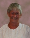
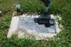
Sharon Kay Ertelt Dahl
| Birth | : | 9 Dec 1945 Valley City, Barnes County, North Dakota, USA |
| Death | : | 5 May 2012 Valley City, Barnes County, North Dakota, USA |
| Burial | : | Linden Cemetery, Watson, Atchison County, USA |
| Coordinate | : | 40.4856130, -95.5383220 |
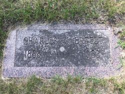
| Description | : | Sharon Kay Ertelt was born on December 9, 1945 in Valley City, ND, the daughter of Charles and Verna (Bevins) Ertelt. She was baptized on October 12, 1948 and confirmed February 28, 1960. She lived in Steele, ND and then moved to Oriska, ND. For many years, she worked for the ND Department of Transportation doing traffic control for road construction. After her retirement, she moved to Medina. Her hobbies included collecting angels and dolls. She enjoyed gardening. Sharon had two cats as well as her constant companion, her dog, Sophie. Sharon is survived by her children, Timothy Dahl, Tamala... Read More |
frequently asked questions (FAQ):
-
Where is Sharon Kay Ertelt Dahl's memorial?
Sharon Kay Ertelt Dahl's memorial is located at: Linden Cemetery, Watson, Atchison County, USA.
-
When did Sharon Kay Ertelt Dahl death?
Sharon Kay Ertelt Dahl death on 5 May 2012 in Valley City, Barnes County, North Dakota, USA
-
Where are the coordinates of the Sharon Kay Ertelt Dahl's memorial?
Latitude: 40.4856130
Longitude: -95.5383220
Family Members:
Parent
Flowers:


Nearby Cemetories:
1. Linden Cemetery
Watson, Atchison County, USA
Coordinate: 40.4856130, -95.5383220
2. Klaus Burial Site
Watson, Atchison County, USA
Coordinate: 40.4917400, -95.5440620
3. Clipfield Family Cemetery
Linden, Atchison County, USA
Coordinate: 40.4925560, -95.5313590
4. Stoner Cemetery
Atchison County, USA
Coordinate: 40.5127983, -95.5618973
5. High Creek Cemetery
Rock Port, Atchison County, USA
Coordinate: 40.5086780, -95.5690380
6. Addington Cemetery
Watson, Atchison County, USA
Coordinate: 40.4721985, -95.5828018
7. Kinser Burial Site
Watson, Atchison County, USA
Coordinate: 40.4974350, -95.5908610
8. Smith Cemetery
Rock Port, Atchison County, USA
Coordinate: 40.4375000, -95.5028000
9. Grange Hall Cemetery
Rock Port, Atchison County, USA
Coordinate: 40.5311012, -95.4863968
10. County Home Cemetery
Rock Port, Atchison County, USA
Coordinate: 40.4180310, -95.5163740
11. Lansdown family burial site
Rock Port, Atchison County, USA
Coordinate: 40.4154319, -95.5522575
12. Millsap Cemetery
Rock Port, Atchison County, USA
Coordinate: 40.4150009, -95.5532990
13. Greenhill Cemetery
Rock Port, Atchison County, USA
Coordinate: 40.4143982, -95.5074997
14. Clayton-Lewis Cemetery
Rock Port, Atchison County, USA
Coordinate: 40.5439730, -95.6102280
15. Elmwood Cemetery
Rock Port, Atchison County, USA
Coordinate: 40.4062740, -95.5206080
16. Saint John's Church Cemetery
Atchison County, USA
Coordinate: 40.5382000, -95.4465000
17. Sonora Cemetery
Watson, Atchison County, USA
Coordinate: 40.4730988, -95.6521988
18. Union Cemetery
Rock Port, Atchison County, USA
Coordinate: 40.5685000, -95.6110000
19. Mount Olive Cemetery
Hamburg, Fremont County, USA
Coordinate: 40.5938721, -95.5939484
20. Beehive Cemetery
Washington Township, Fremont County, USA
Coordinate: 40.5918740, -95.6087003
21. Hunter Cemetery
Rock Port, Atchison County, USA
Coordinate: 40.3636017, -95.5216980
22. Buckmiller Burial Site
Tarkio, Atchison County, USA
Coordinate: 40.4121111, -95.4033806
23. Walnut Grove Cemetery
Brownville, Nemaha County, USA
Coordinate: 40.4023056, -95.6642990
24. Honey Creek Cemetery
Nemaha Township, Nemaha County, USA
Coordinate: 40.4430199, -95.6980820