
| Birth | : | 7 Jul 1940 Hayti, Hamlin County, South Dakota, USA |
| Death | : | 6 Jan 2018 Pierre, Hughes County, South Dakota, USA |
| Burial | : | Mount Calvary Cemetery, Pierre, Hughes County, USA |
| Coordinate | : | 44.4197006, -100.3557968 |
| Inscription | : | Married Dec 26, 1960 Parents of: Kevin, Kim, Pat, Dan, Brian, Tammie, Kristie, Brad |
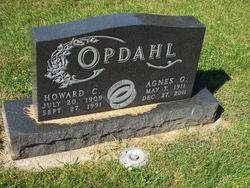
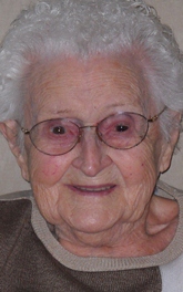
| Description | : | Sharon Marie Paulsen passed away on Jan. 6, 2018, at her home. Visitation will be on Jan. 11 from 5 to 7 p.m. followed by a prayer service at 7 p.m. at Isburg Funeral Chapel. Funeral services will be at 10:30 a.m. on Friday, Jan. 12 at Saints Peter and Paul Catholic Church with Father Joseph Holzhauser officiating. Burial will be at the Calvary Catholic Cemetery. Sharon Marie Opdahl was born on July 7, 1940, in Watertown to Howard and Agnes (Coplan) Opdahl. She grew up on a dairy farm in Hayti with her six siblings. |
frequently asked questions (FAQ):
-
Where is Sharon Marie Opdahl Paulsen's memorial?
Sharon Marie Opdahl Paulsen's memorial is located at: Mount Calvary Cemetery, Pierre, Hughes County, USA.
-
When did Sharon Marie Opdahl Paulsen death?
Sharon Marie Opdahl Paulsen death on 6 Jan 2018 in Pierre, Hughes County, South Dakota, USA
-
Where are the coordinates of the Sharon Marie Opdahl Paulsen's memorial?
Latitude: 44.4197006
Longitude: -100.3557968
Family Members:
Parent
Spouse

Siblings
Flowers:


Nearby Cemetories:
1. Mount Calvary Cemetery
Pierre, Hughes County, USA
Coordinate: 44.4197006, -100.3557968
2. Fort Pierre Chouteau Cemetery
Fort Pierre, Stanley County, USA
Coordinate: 44.3908700, -100.3878300
3. Scotty Philip Cemetery
Fort Pierre, Stanley County, USA
Coordinate: 44.4019012, -100.4036026
4. South Dakota State Capitol Grounds
Pierre, Hughes County, USA
Coordinate: 44.3660100, -100.3448000
5. Riverside Cemetery
Pierre, Hughes County, USA
Coordinate: 44.3608017, -100.3071976
6. Cedar Hill Cemetery
Fort Pierre, Stanley County, USA
Coordinate: 44.3356018, -100.3964005
7. Byron Township Cemetery
Blunt, Hughes County, USA
Coordinate: 44.4979200, -100.1904700
8. Canning Cemetery
Hughes County, USA
Coordinate: 44.3986890, -100.0278460
9. Okobojo Cemetery
Sully County, USA
Coordinate: 44.6568985, -100.3647003
10. Fort Sully Post Cemetery
Sully County, USA
Coordinate: 44.5866480, -100.6087530
11. Pleasant Hill Cemetery
Blunt, Hughes County, USA
Coordinate: 44.5135994, -100.0156021
12. Meers Cemetery
Stanley County, USA
Coordinate: 44.4116970, -100.7360760
13. Holy Name Episcopal Cemetery
Fort Pierre, Stanley County, USA
Coordinate: 44.2694960, -100.0357300
14. Holy Name Chapel Cemetery
Fort Pierre, Stanley County, USA
Coordinate: 44.2694292, -100.0356989
15. Mathews Family Cemetery
Stanley County, USA
Coordinate: 44.1816040, -100.5581080
16. Fort Bennett Post Cemetery
Stanley County, USA
Coordinate: 44.6716500, -100.6404200
17. Onida Cemetery
Onida, Sully County, USA
Coordinate: 44.7147000, -100.0650000
18. Chapelle Cemetery
Hughes County, USA
Coordinate: 44.3025017, -99.8653030
19. Blair Cemetery
Sully County, USA
Coordinate: 44.8027992, -100.4199982
20. Holy Faith Cemetery
Lyman County, USA
Coordinate: 44.1356010, -99.9878006
21. Mission Ridge Cemetery
Mission Ridge, Stanley County, USA
Coordinate: 44.6960983, -100.7716980
22. Immanuel Lutheran Cemetery
Van Metre, Jones County, USA
Coordinate: 44.0958800, -100.7263300
23. Medicine Hill Cemetery
Harrold, Hughes County, USA
Coordinate: 44.5116997, -99.7453003
24. Saint John Catholic Cemetery
Harrold, Hughes County, USA
Coordinate: 44.5127983, -99.7335968