
| Birth | : | 4 Sep 1928 North Dakota, USA |
| Death | : | 5 Oct 2018 California, USA |
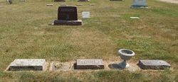
| Burial | : | Goleta Cemetery, Goleta, Santa Barbara County, USA |
| Coordinate | : | 34.4407997, -119.7802963 |
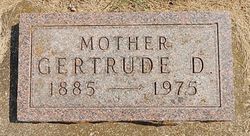
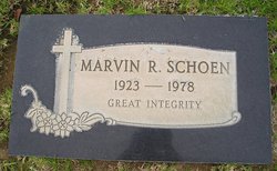
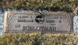
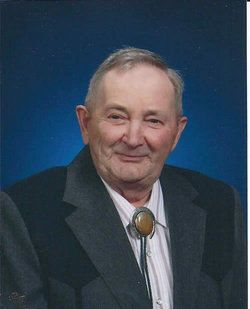
| Description | : | Shirley Edith Schoen SEPTEMBER 4, 1928 – OCTOBER 5, 2018 Graveside Service November 2, 2018 1:00 pm GOLETA CEMETERY 44 S. San Antonio Road Santa Barbara, California 93110 People's Funeral Chapel, Hanford, California Shirley Schlotman Schoen, 90, of Hanford, CA passed away Friday, October 5th in her home at Diamond Terraces Assisted Living Center in Hanford. Born in Carrington, ND to John and Gertrude Schlotman, Shirley lived most of her adult life in Santa Barbara, and after retirement in Hanford. She was married to the late Marvin Schoen in 1949. Shirley enjoyed her years working... Read More |
frequently asked questions (FAQ):
-
Where is Shirley Edith Schlotman Schoen's memorial?
Shirley Edith Schlotman Schoen's memorial is located at: Goleta Cemetery, Goleta, Santa Barbara County, USA.
-
When did Shirley Edith Schlotman Schoen death?
Shirley Edith Schlotman Schoen death on 5 Oct 2018 in California, USA
-
Where are the coordinates of the Shirley Edith Schlotman Schoen's memorial?
Latitude: 34.4407997
Longitude: -119.7802963
Family Members:
Parent
Spouse
Siblings

Flowers:


Nearby Cemetories:
1. Goleta Cemetery
Goleta, Santa Barbara County, USA
Coordinate: 34.4407997, -119.7802963
2. Cieneguitas Catholic Cemetery
La Patera, Santa Barbara County, USA
Coordinate: 34.4402920, -119.7744090
3. Potters Field Cemetery
Goleta, Santa Barbara County, USA
Coordinate: 34.4526310, -119.7686540
4. Christ the King Episcopal Church Memorial Garden
Santa Barbara, Santa Barbara County, USA
Coordinate: 34.4343418, -119.7998439
5. Calvary Cemetery
Santa Barbara, Santa Barbara County, USA
Coordinate: 34.4432983, -119.7466965
6. Mission Santa Barbara Cemetery
Santa Barbara, Santa Barbara County, USA
Coordinate: 34.4378800, -119.7134600
7. Presidio Cemetery
Santa Barbara, Santa Barbara County, USA
Coordinate: 34.4228790, -119.6991480
8. Santa Barbara Cemetery
Santa Barbara, Santa Barbara County, USA
Coordinate: 34.4188995, -119.6544037
9. All Saints By The Sea Episcopal Church Columbarium
Montecito, Santa Barbara County, USA
Coordinate: 34.4210500, -119.6312100
10. Montecito Cemetery
Montecito, Santa Barbara County, USA
Coordinate: 34.4363080, -119.5959850
11. Carpinteria Cemetery
Carpinteria, Santa Barbara County, USA
Coordinate: 34.4118996, -119.5385971
12. Ferrer Family Ranch Grounds
Carpinteria, Santa Barbara County, USA
Coordinate: 34.3821940, -119.4812560
13. Rancho del Cielo Cemetery
Santa Barbara, Santa Barbara County, USA
Coordinate: 34.5304780, -120.0758920
14. Capuchin Cemetery
Santa Ynez, Santa Barbara County, USA
Coordinate: 34.6442860, -120.0270440
15. Mission Santa Ines Cemetery
Solvang, Santa Barbara County, USA
Coordinate: 34.5943880, -120.1365550
16. Oak Hill Cemetery
Ballard, Santa Barbara County, USA
Coordinate: 34.6324997, -120.1106033
17. Solvang Cemetery
Solvang, Santa Barbara County, USA
Coordinate: 34.6017000, -120.1443920
18. Saint Mark's-in-the-Valley Church Mem. Garden
Los Olivos, Santa Barbara County, USA
Coordinate: 34.6662590, -120.1177210
19. Ojai United Methodist Memorial Garden
Ojai, Ventura County, USA
Coordinate: 34.4437040, -119.2665540
20. Saint Thomas Aquinas Cemetery
Ojai, Ventura County, USA
Coordinate: 34.4301250, -119.2650250
21. Nordhoff Cemetery
Ojai, Ventura County, USA
Coordinate: 34.4446600, -119.2604400
22. Mission San Buenaventura Cemetery
Ventura, Ventura County, USA
Coordinate: 34.2811890, -119.2982090
23. Ojai Presbyterian Church Columbarium
Ojai, Ventura County, USA
Coordinate: 34.4494250, -119.2530420
24. Saint Andrews Episcopal Church Columbarium
Ojai, Ventura County, USA
Coordinate: 34.4454300, -119.2513700