
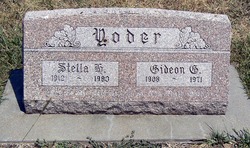
Stella Hostetler Yoder
| Birth | : | 25 Jan 1912 Harper, Harper County, Kansas, USA |
| Death | : | 8 Mar 1983 Hesston, Harvey County, Kansas, USA |
| Burial | : | Holy Cross Cemetery, Fort Smith, Sebastian County, USA |
| Coordinate | : | 35.3978004, -94.3685989 |
| Description | : | Yoder, Stella, daughter of Henry E. and Salome (Slabach) Hostetler, was born at Harper, Kan., Jan. 25, 1912; died at Hesston, Kan., Mar. 8, 1983; aged 71 y. On Aug. 30, 1936, she was married to Gideon G. Yoder, who died in 1971. She was a member of Hesston Inter-Mennonite Fellowship, where funeral services were held on Mar. 11, in charge of Waldo E. Miller; interment in East Lawn Cemetery. Obituary courtesy of Adalbert Goertz. |
frequently asked questions (FAQ):
-
Where is Stella Hostetler Yoder's memorial?
Stella Hostetler Yoder's memorial is located at: Holy Cross Cemetery, Fort Smith, Sebastian County, USA.
-
When did Stella Hostetler Yoder death?
Stella Hostetler Yoder death on 8 Mar 1983 in Hesston, Harvey County, Kansas, USA
-
Where are the coordinates of the Stella Hostetler Yoder's memorial?
Latitude: 35.3978004
Longitude: -94.3685989
Family Members:
Parent

Spouse

Siblings
Children
Flowers:


Nearby Cemetories:
1. Holy Cross Cemetery
Fort Smith, Sebastian County, USA
Coordinate: 35.3978004, -94.3685989
2. Rose Lawn Park Cemetery
Fort Smith, Sebastian County, USA
Coordinate: 35.3917007, -94.3700027
3. RoseLawn Park Columbarium
Fort Smith, Sebastian County, USA
Coordinate: 35.3917000, -94.3700000
4. Washington Cemetery
Fort Smith, Sebastian County, USA
Coordinate: 35.4095980, -94.3713360
5. Forest Park Cemetery
Fort Smith, Sebastian County, USA
Coordinate: 35.4261017, -94.3719025
6. Saint Scholastica Cemetery
Fort Smith, Sebastian County, USA
Coordinate: 35.3700890, -94.3842790
7. Nolon Springs Cemetery
Fort Smith, Sebastian County, USA
Coordinate: 35.4291992, -94.3843994
8. Oak Cemetery
Fort Smith, Sebastian County, USA
Coordinate: 35.3694000, -94.4017029
9. First United Methodist Church Columbarium
Fort Smith, Sebastian County, USA
Coordinate: 35.3834560, -94.4150440
10. First Presbyterian Church Columbarium
Fort Smith, Sebastian County, USA
Coordinate: 35.3849900, -94.4182700
11. Immaculate Conception Catholic Columbarium
Fort Smith, Sebastian County, USA
Coordinate: 35.3828960, -94.4184930
12. Goddard United Methodistb Church Columbarium
Fort Smith, Sebastian County, USA
Coordinate: 35.3720830, -94.4129730
13. Christ the King Catholic Church Columbarium
Fort Smith, Sebastian County, USA
Coordinate: 35.3641970, -94.4045960
14. Calvary Cemetery
Fort Smith, Sebastian County, USA
Coordinate: 35.3764000, -94.4167023
15. Saint John Episcopal Church Columbarium
Fort Smith, Sebastian County, USA
Coordinate: 35.3895490, -94.4234350
16. Jewish Cemetery
Fort Smith, Sebastian County, USA
Coordinate: 35.3757000, -94.4176000
17. Fairview Cemetery
Van Buren, Crawford County, USA
Coordinate: 35.4411011, -94.3503036
18. Saint Bartholomew Episcopal Church Garden
Fort Smith, Sebastian County, USA
Coordinate: 35.3571380, -94.3945150
19. Crown Hill Cemetery
Van Buren, Crawford County, USA
Coordinate: 35.4337910, -94.3329620
20. Fort Smith National Cemetery
Fort Smith, Sebastian County, USA
Coordinate: 35.3838997, -94.4291992
21. Trinity Columbarium
Van Buren, Crawford County, USA
Coordinate: 35.4484650, -94.3496980
22. Gracelawn Cemetery
Van Buren, Crawford County, USA
Coordinate: 35.4462500, -94.3268500
23. Falconer Cemetery
Fort Smith, Sebastian County, USA
Coordinate: 35.3374810, -94.3939300
24. Gill Cemetery
Van Buren, Crawford County, USA
Coordinate: 35.4353676, -94.3029861