
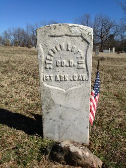
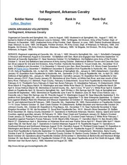
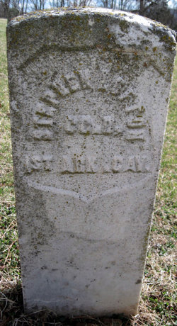


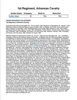
Stephen Lofton
| Birth | : | 1818 Lawrence County, Mississippi, USA |
| Death | : | 16 May 1864 West Fork, Washington County, Arkansas, USA |
| Burial | : | Evergreen Township Cemetery, Sheridan, Montcalm County, USA |
| Coordinate | : | 43.2200600, -85.0472300 |
| Description | : | Company D 1st Arkansas Calvary Civil War Union Killed by bushwhackers while home on furlough |
frequently asked questions (FAQ):
-
Where is Stephen Lofton's memorial?
Stephen Lofton's memorial is located at: Evergreen Township Cemetery, Sheridan, Montcalm County, USA.
-
When did Stephen Lofton death?
Stephen Lofton death on 16 May 1864 in West Fork, Washington County, Arkansas, USA
-
Where are the coordinates of the Stephen Lofton's memorial?
Latitude: 43.2200600
Longitude: -85.0472300
Family Members:
Parent
Spouse
Siblings
Children

Flowers:


Nearby Cemetories:
1. Evergreen Township Cemetery
Sheridan, Montcalm County, USA
Coordinate: 43.2200600, -85.0472300
2. Sheridan Cemetery
Sheridan, Montcalm County, USA
Coordinate: 43.2061920, -85.0653030
3. Vickeryville Cemetery
Vickeryville, Montcalm County, USA
Coordinate: 43.1917000, -84.9760971
4. Sidney Township Cemetery
Sidney, Montcalm County, USA
Coordinate: 43.2503100, -85.1369600
5. Forest Hill Cemetery
Stanton, Montcalm County, USA
Coordinate: 43.2910995, -85.0883026
6. Potters Field
Greenville, Montcalm County, USA
Coordinate: 43.1922500, -85.1628000
7. North Sidney Cemetery
Sidney, Montcalm County, USA
Coordinate: 43.2658600, -85.1533500
8. Sunny Hill Cemetery
Fenwick, Montcalm County, USA
Coordinate: 43.1319008, -85.0002975
9. Vickeryville Old Order Mennonite Church Cemetery
Vickeryville, Montcalm County, USA
Coordinate: 43.1734880, -84.9342820
10. Crystal Cemetery
Crystal, Montcalm County, USA
Coordinate: 43.2347470, -84.9158600
11. South Sidney Cemetery
Sidney, Montcalm County, USA
Coordinate: 43.2208050, -85.1826570
12. Clear Lake Cemetery
Fenwick, Montcalm County, USA
Coordinate: 43.1264000, -85.0943985
13. Fairplains Cemetery
Greenville, Montcalm County, USA
Coordinate: 43.1561400, -85.1722400
14. Burke Cemetery
Carson City, Montcalm County, USA
Coordinate: 43.2196999, -84.8852997
15. McBride Cemetery
McBride, Montcalm County, USA
Coordinate: 43.3493996, -85.0382996
16. Bloomer Township Cemetery
Carson City, Montcalm County, USA
Coordinate: 43.1516991, -84.8949966
17. Palo Cemetery
Palo, Ionia County, USA
Coordinate: 43.1100000, -84.9380000
18. Dalton Cemetery
Carson City, Montcalm County, USA
Coordinate: 43.1202400, -84.9157500
19. Palmer Cemetery
Day Township, Montcalm County, USA
Coordinate: 43.3588982, -85.0627975
20. Woodard Lake Cemetery
Palo, Ionia County, USA
Coordinate: 43.0794990, -85.0591780
21. Snows Cemetery
Shiloh, Ionia County, USA
Coordinate: 43.0741997, -85.0357971
22. Carson City Cemetery
Carson City, Montcalm County, USA
Coordinate: 43.1850300, -84.8508400
23. Saint Marys Cemetery
Carson City, Montcalm County, USA
Coordinate: 43.1847600, -84.8508400
24. East Montcalm Cemetery
Greenville, Montcalm County, USA
Coordinate: 43.2266998, -85.2510986