
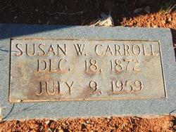

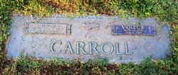
Susan G. White Carroll
| Birth | : | 18 Dec 1872 York County, South Carolina, USA |
| Death | : | 9 Jul 1959 Blacksburg, Cherokee County, South Carolina, USA |
| Burial | : | Crowle Cemetery, Crowle, North Lincolnshire Unitary Authority, England |
| Coordinate | : | 53.6090660, -0.8285680 |
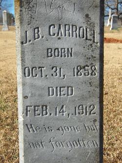
| Description | : | Mrs. J. B. Carroll Blacksburg. Mrs. Susan White Carroll, 87, widow of J. B. Carroll, died about 2:20 o'clock Thursday afternoon at the home of a son, Ben Carroll, on Blacksburg route 1. A lifelong resident of Cherokee county, Mrs. Carroll was a member of the First Baptist Church of Grover, N. C. Funeral services were conducted Friday afternoon at 4 o'clock at the home of her son, Richard Carroll, on Chester street. The Rev. Coy R. Miller, pastor of the First Baptist Church, and the Rev. J. G. Brawley, pastor of the Associate Reformed Presbyterian Church, officiated. Interment was... Read More |
frequently asked questions (FAQ):
-
Where is Susan G. White Carroll's memorial?
Susan G. White Carroll's memorial is located at: Crowle Cemetery, Crowle, North Lincolnshire Unitary Authority, England.
-
When did Susan G. White Carroll death?
Susan G. White Carroll death on 9 Jul 1959 in Blacksburg, Cherokee County, South Carolina, USA
-
Where are the coordinates of the Susan G. White Carroll's memorial?
Latitude: 53.6090660
Longitude: -0.8285680
Family Members:
Spouse
Children


Nearby Cemetories:
1. Crowle Cemetery
Crowle, North Lincolnshire Unitary Authority, England
Coordinate: 53.6090660, -0.8285680
2. Crowle Baptist Church
Crowle, North Lincolnshire Unitary Authority, England
Coordinate: 53.6093970, -0.8317350
3. St Oswald Churchyard
Crowle, North Lincolnshire Unitary Authority, England
Coordinate: 53.6077330, -0.8353940
4. St Bartholomews Churchyard
Eastoft, North Lincolnshire Unitary Authority, England
Coordinate: 53.6397700, -0.7823500
5. St Oswald Churchyard
Althorpe, North Lincolnshire Unitary Authority, England
Coordinate: 53.5765570, -0.7408910
6. All Saints Churchyard
Belton, North Lincolnshire Unitary Authority, England
Coordinate: 53.5478600, -0.8199200
7. St John The Baptist Churchyard Extension
Burringham, North Lincolnshire Unitary Authority, England
Coordinate: 53.5708230, -0.7439800
8. St Oswald Church
Luddington, North Lincolnshire Unitary Authority, England
Coordinate: 53.6448740, -0.7387490
9. St Marks Church
Amcotts, North Lincolnshire Unitary Authority, England
Coordinate: 53.6166950, -0.7088900
10. St. Wilfrith's Churchyard
Moorends, Metropolitan Borough of Doncaster, England
Coordinate: 53.6306940, -0.9502050
11. Thorne Cemetery
Thorne, Metropolitan Borough of Doncaster, England
Coordinate: 53.6084100, -0.9572000
12. St. Nicholas Churchyard
Thorne, Metropolitan Borough of Doncaster, England
Coordinate: 53.6116500, -0.9580000
13. Baptist Burial Ground
West Butterwick, North Lincolnshire Unitary Authority, England
Coordinate: 53.5432720, -0.7423210
14. St Andrew Churchyard
Epworth, North Lincolnshire Unitary Authority, England
Coordinate: 53.5256450, -0.8231740
15. St Mary the Virgin Churchyard
West Butterwick, North Lincolnshire Unitary Authority, England
Coordinate: 53.5426407, -0.7412120
16. St Mary the Virgin Church
Fockerby, North Lincolnshire Unitary Authority, England
Coordinate: 53.6613050, -0.7138730
17. All Saints' Churchyard
Flixborough, North Lincolnshire Unitary Authority, England
Coordinate: 53.6247100, -0.6819480
18. Epworth Municipal Cemetery
Epworth, North Lincolnshire Unitary Authority, England
Coordinate: 53.5206600, -0.8239000
19. All Saints Churchyard Old
Flixborough, North Lincolnshire Unitary Authority, England
Coordinate: 53.6178950, -0.6754930
20. All Saints Churchyard
Adlingfleet, East Riding of Yorkshire Unitary Authority, England
Coordinate: 53.6786760, -0.7238110
21. St Andrew's Church
Burton upon Stather, North Lincolnshire Unitary Authority, England
Coordinate: 53.6501180, -0.6850550
22. Woodlands Cemetery and Crematorium
Scunthorpe, North Lincolnshire Unitary Authority, England
Coordinate: 53.5810900, -0.6744900
23. St. John the Evangelist Churchyard
Goole, East Riding of Yorkshire Unitary Authority, England
Coordinate: 53.7024600, -0.8719260
24. Crosby Cemetery
Scunthorpe, North Lincolnshire Unitary Authority, England
Coordinate: 53.5978800, -0.6639600