

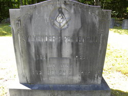
Sylvender B Pettengill
| Birth | : | Jan 1862 Sandwich, Carroll County, New Hampshire, USA |
| Death | : | 14 Apr 1932 Lawrence, Essex County, Massachusetts, USA |
| Burial | : | Grove Cemetery, Sandwich, Carroll County, USA |
| Coordinate | : | 43.8101100, -71.4445200 |
frequently asked questions (FAQ):
-
Where is Sylvender B Pettengill's memorial?
Sylvender B Pettengill's memorial is located at: Grove Cemetery, Sandwich, Carroll County, USA.
-
When did Sylvender B Pettengill death?
Sylvender B Pettengill death on 14 Apr 1932 in Lawrence, Essex County, Massachusetts, USA
-
Where are the coordinates of the Sylvender B Pettengill's memorial?
Latitude: 43.8101100
Longitude: -71.4445200
Family Members:
Parent

Spouse
Flowers:


Nearby Cemetories:
1. Grove Cemetery
Sandwich, Carroll County, USA
Coordinate: 43.8101100, -71.4445200
2. Baptist Burial Ground
Center Sandwich, Carroll County, USA
Coordinate: 43.8079900, -71.4392600
3. Elm Hill Cemetery
Sandwich, Carroll County, USA
Coordinate: 43.8158330, -71.4338890
4. Elm Hill Cemetery
Center Sandwich, Carroll County, USA
Coordinate: 43.8158000, -71.4336000
5. Cemetery of the Religious Society of Friends
Sandwich, Carroll County, USA
Coordinate: 43.7994400, -71.4266700
6. Chicks Corner Cemetery
Sandwich, Carroll County, USA
Coordinate: 43.8041000, -71.4728900
7. Beede Cemetery
Sandwich, Carroll County, USA
Coordinate: 43.8013890, -71.4166670
8. Mason Cemetery
Center Sandwich, Carroll County, USA
Coordinate: 43.7858000, -71.4258000
9. Israel Gilman Cemetery
Sandwich Landing, Carroll County, USA
Coordinate: 43.8268727, -71.4757671
10. Smith-Morse Cemetery
Sandwich, Carroll County, USA
Coordinate: 43.7768000, -71.4301000
11. Moulton-Beede Cemetery
Sandwich, Carroll County, USA
Coordinate: 43.7774000, -71.4276000
12. Littles Pond Cemetery
Sandwich, Carroll County, USA
Coordinate: 43.7915600, -71.4034200
13. Haines Cemetery
Union, Carroll County, USA
Coordinate: 43.7734000, -71.4331000
14. Quinby Cemetery
North Sandwich, Carroll County, USA
Coordinate: 43.8433000, -71.4148000
15. Thompson Cemetery
Sandwich, Carroll County, USA
Coordinate: 43.8014000, -71.5025000
16. Mason Cemetery
North Sandwich, Carroll County, USA
Coordinate: 43.8542000, -71.4426000
17. Morse Cemetery
Center Sandwich, Carroll County, USA
Coordinate: 43.8534300, -71.4241600
18. North Sandwich Cemetery
North Sandwich, Carroll County, USA
Coordinate: 43.8410750, -71.3953610
19. Mears-Nelson Cemetery
Sandwich, Carroll County, USA
Coordinate: 43.7932790, -71.3820560
20. Nathanial Fry Family Plot
Sandwich, Carroll County, USA
Coordinate: 43.7875872, -71.3844592
21. Richard Fry Cemetery
Sandwich, Carroll County, USA
Coordinate: 43.7822817, -71.3830099
22. Mason Cemetery
Moultonborough, Carroll County, USA
Coordinate: 43.7574500, -71.4184000
23. Freese Cemetery
Moultonborough, Carroll County, USA
Coordinate: 43.7616670, -71.4008330
24. Holland Hill Cemetery
Moultonborough, Carroll County, USA
Coordinate: 43.7620300, -71.3995400