
| Birth | : | 16 Jun 1928 Baldwin, Gilmer County, West Virginia, USA |
| Death | : | 21 Jul 2010 Weston, Lewis County, West Virginia, USA |
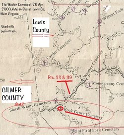
| Burial | : | Rock Grove Cemetery, Latonia, Gilmer County, USA |
| Coordinate | : | 39.0125008, -80.7018967 |
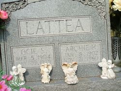
| Description | : | Obituary from the Weston Democrat Wednesday July 28, 2010: Sylvia Pauline Shackleford, 82, of 624 Lynn Avenue, Weston, died Wednesday, July 21, 2010, at her residence following an extended illness. She was born June 16, 1928 in Baldwin, Gilmer County, a daughter of the late Archie H. Lattea and Ocie Starcher Lattea. In April of 1947 she married William P. Lunsford, who preceded her in death in December of 1984; she then married Lee Shackleford in February of 1986, who preceded her in death in October 2004. In addition to her parents and husbands, she was preceded... Read More |
frequently asked questions (FAQ):
-
Where is Sylvia Pauline Lattea Shackleford's memorial?
Sylvia Pauline Lattea Shackleford's memorial is located at: Rock Grove Cemetery, Latonia, Gilmer County, USA.
-
When did Sylvia Pauline Lattea Shackleford death?
Sylvia Pauline Lattea Shackleford death on 21 Jul 2010 in Weston, Lewis County, West Virginia, USA
-
Where are the coordinates of the Sylvia Pauline Lattea Shackleford's memorial?
Latitude: 39.0125008
Longitude: -80.7018967
Family Members:
Parent

Spouse
Siblings

Children
Flowers:


Nearby Cemetories:
1. Rock Grove Cemetery
Latonia, Gilmer County, USA
Coordinate: 39.0125008, -80.7018967
2. Moneypenny Cemetery
Alum Bridge, Lewis County, USA
Coordinate: 39.0281466, -80.6809317
3. Woofter Cemetery
Alum Bridge, Lewis County, USA
Coordinate: 39.0299988, -80.6808014
4. Farnsworth Cemetery
Linn, Gilmer County, USA
Coordinate: 39.0177994, -80.7378006
5. Pickerel Cemetery
Baldwin, Gilmer County, USA
Coordinate: 38.9891200, -80.7289800
6. Carder Cemetery
Vadis, Lewis County, USA
Coordinate: 39.0433006, -80.7142029
7. Old Field Fork Cemetery
Lewis County, USA
Coordinate: 38.9827995, -80.6710968
8. Troy IOOF Community Cemetery
Troy, Gilmer County, USA
Coordinate: 39.0281170, -80.7679560
9. Hiney Hill Cemetery
Linn, Gilmer County, USA
Coordinate: 38.9676950, -80.7405600
10. Keith Cemetery
Gilmer County, USA
Coordinate: 38.9561005, -80.6986008
11. Messenger Cemetery
Gilmer County, USA
Coordinate: 38.9714012, -80.7572021
12. Saint Boniface Catholic Cemetery
Camden, Lewis County, USA
Coordinate: 39.0342580, -80.6288680
13. Hurst Cemetery
Lewis County, USA
Coordinate: 39.0741997, -80.6999969
14. Boilon Cemetery
Gilmer County, USA
Coordinate: 38.9519005, -80.6718979
15. Walnut Fork Cemetery
Lewis County, USA
Coordinate: 39.0706910, -80.6644980
16. Schoonover-Dawson Cemetery
Donlan, Gilmer County, USA
Coordinate: 38.9461770, -80.6854790
17. Halderman Cemetery
Lewis County, USA
Coordinate: 39.0821991, -80.7039032
18. Straight Run Cemetery
Hurst, Lewis County, USA
Coordinate: 39.0802994, -80.6774979
19. Rogers Cemetery
Gilmer County, USA
Coordinate: 38.9406013, -80.6936035
20. McHenry Cemetery #1
Sand Fork, Gilmer County, USA
Coordinate: 38.9353310, -80.7162630
21. McHenry Cemetery
Gilmer County, USA
Coordinate: 38.9341870, -80.7130200
22. Conrad Cemetery
Sand Fork, Gilmer County, USA
Coordinate: 38.9364014, -80.7296982
23. Big Run Cemetery
Gilmer County, USA
Coordinate: 39.0802994, -80.7585983
24. Dyer Cemetery
Gilmer County, USA
Coordinate: 38.9319000, -80.7110977