
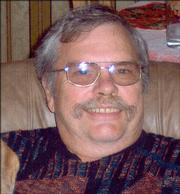
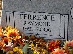
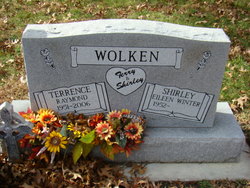
Terrence Raymond “Terry” Wolken
| Birth | : | 5 Jan 1951 Garnett, Anderson County, Kansas, USA |
| Death | : | 14 May 2006 Lawrence, Douglas County, Kansas, USA |
| Burial | : | Mount Calvary Catholic Cemetery, Lawrence, Douglas County, USA |
| Coordinate | : | 38.9580002, -95.2139969 |
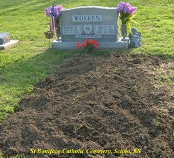
| Description | : | Mass of Christian burial for Terrence "Terry" Raymond Wolken, 55, Lawrence, will be at 10 a.m. Friday at Corpus Christi Catholic Church. Burial will be at Mount Calvary Cemetery. Mr. Wolken died Sunday, May 14, 2006, at his home. He was born Jan. 5, 1951, in Garnett, the son of Robert and Beatrice "Betty" Jacobs Wolken. He was raised and attended school in Scipio. Mr. Wolken was self-employed as a floor covering installer in the Lawrence area for more than 30 years. He married Shirley E. Winter on Oct. 15, 1994. She survives. Other survivors include his mother, Betty Wolken, Pittsburg; a daughter, Tracy Pobjoy,... Read More |
frequently asked questions (FAQ):
-
Where is Terrence Raymond “Terry” Wolken's memorial?
Terrence Raymond “Terry” Wolken's memorial is located at: Mount Calvary Catholic Cemetery, Lawrence, Douglas County, USA.
-
When did Terrence Raymond “Terry” Wolken death?
Terrence Raymond “Terry” Wolken death on 14 May 2006 in Lawrence, Douglas County, Kansas, USA
-
Where are the coordinates of the Terrence Raymond “Terry” Wolken's memorial?
Latitude: 38.9580002
Longitude: -95.2139969
Family Members:
Parent

Siblings
Flowers:


Nearby Cemetories:
1. Mount Calvary Catholic Cemetery
Lawrence, Douglas County, USA
Coordinate: 38.9580002, -95.2139969
2. Oak Hill Cemetery
Lawrence, Douglas County, USA
Coordinate: 38.9589005, -95.2118988
3. Memorial Park Cemetery
Lawrence, Douglas County, USA
Coordinate: 38.9552994, -95.2153015
4. Trinity Episcopal Church Columbarium
Lawrence, Douglas County, USA
Coordinate: 38.9653893, -95.2373886
5. Saint Johns Catholic Cemetery
Douglas County, USA
Coordinate: 38.9437900, -95.1919600
6. Dyche Hall Natural History Museum
Lawrence, Douglas County, USA
Coordinate: 38.9584800, -95.2434800
7. Haskell Cemetery
Lawrence, Douglas County, USA
Coordinate: 38.9353790, -95.2284241
8. Franklin Cemetery
Douglas County, USA
Coordinate: 38.9437523, -95.1869431
9. Pioneer Cemetery
Lawrence, Douglas County, USA
Coordinate: 38.9528008, -95.2611008
10. First Presbyterian Church Memorial Garden
Lawrence, Douglas County, USA
Coordinate: 38.9414900, -95.2641600
11. Maple Grove Cemetery
Lawrence, Douglas County, USA
Coordinate: 39.0018997, -95.2316971
12. County Poor Farm Cemetery
Douglas County, USA
Coordinate: 38.9119400, -95.2214600
13. Adams Cemetery
Douglas County, USA
Coordinate: 38.9955400, -95.2509100
14. Kennedy Cemetery
Douglas County, USA
Coordinate: 38.9112900, -95.2269200
15. Davis Cemetery
Lawrence, Douglas County, USA
Coordinate: 38.9722500, -95.2831100
16. Blue Mound Cemetery
Lawrence, Douglas County, USA
Coordinate: 38.9046600, -95.1865400
17. Marshall Cemetery
Douglas County, USA
Coordinate: 38.9040800, -95.2446700
18. Dutton Cemetery
Douglas County, USA
Coordinate: 38.8989800, -95.2790600
19. Luckan Family Cemetery
Fall Leaf, Leavenworth County, USA
Coordinate: 38.9808500, -95.1128000
20. Cemetery Beni Israel
Eudora, Douglas County, USA
Coordinate: 38.9280128, -95.1122208
21. Lyon Family Cemetery
Lawrence, Douglas County, USA
Coordinate: 38.9877440, -95.3166530
22. Corpus Christi Catholic Church Columbarium
Lawrence, Douglas County, USA
Coordinate: 38.9572250, -95.3238450
23. Southwest City Cemetery
Eudora, Douglas County, USA
Coordinate: 38.9334800, -95.1070300
24. Richland Cemetery
Lawrence, Douglas County, USA
Coordinate: 38.8768997, -95.2630997