
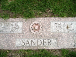
Thelma E. Wendt Sander
| Birth | : | 27 Jun 1902 Humphrey, Platte County, Nebraska, USA |
| Death | : | 21 Aug 2006 Denver, Denver County, Colorado, USA |
| Burial | : | Prairie Union Cemetery, Shubert, Richardson County, USA |
| Coordinate | : | 40.2475800, -95.7150200 |
| Description | : | Daughter of Otto & Alma (Goetz) Wendt. On September 28, 1922, Thelma married Walter A. Sander in Creston, Nebraska. She moved to Longmont in 1964 from Nebraska and to Denver in 2002. Thelma worked in a children's home in Lincoln, Nebraska and in Denver. While in Longmont, she worked at a nursing home. Thelma was a member of the Mount Hope Lutheran Church in Boulder, CO. She enjoyed crocheting and embroidery. Thelma is survived by: Daughter - Aldine (Ralph) Germeroth of Denver, CO Daughter - Lois Klug of Denver, CO Daughter-in-law - Dolores Sander of Platte Center, NE 9 grandchildren 21... Read More |
frequently asked questions (FAQ):
-
Where is Thelma E. Wendt Sander's memorial?
Thelma E. Wendt Sander's memorial is located at: Prairie Union Cemetery, Shubert, Richardson County, USA.
-
When did Thelma E. Wendt Sander death?
Thelma E. Wendt Sander death on 21 Aug 2006 in Denver, Denver County, Colorado, USA
-
Where are the coordinates of the Thelma E. Wendt Sander's memorial?
Latitude: 40.2475800
Longitude: -95.7150200
Family Members:
Parent

Spouse

Siblings
Children
Flowers:


Nearby Cemetories:
1. Prairie Union Cemetery
Shubert, Richardson County, USA
Coordinate: 40.2475800, -95.7150200
2. Penniwell Cemetery
Shubert, Richardson County, USA
Coordinate: 40.2619000, -95.6994500
3. Stella Cemetery
Stella, Richardson County, USA
Coordinate: 40.2268982, -95.7671967
4. Cupola Cemetery
Verdon, Richardson County, USA
Coordinate: 40.1892014, -95.7086029
5. Saint Annes Catholic Cemetery
Shubert, Richardson County, USA
Coordinate: 40.2042500, -95.6549500
6. Brick Church Cemetery
Barada, Richardson County, USA
Coordinate: 40.2328000, -95.6155000
7. Berg Cemetery
Barada, Richardson County, USA
Coordinate: 40.2257996, -95.6168976
8. Huff Cemetery
Barada, Richardson County, USA
Coordinate: 40.2039000, -95.6248500
9. Liberty-Cornell Cemetery
Verdon, Richardson County, USA
Coordinate: 40.1603000, -95.7375000
10. Hillsdale Cemetery
Nemaha County, USA
Coordinate: 40.2882996, -95.6010971
11. Liberty Township Cemetery
Verdon, Richardson County, USA
Coordinate: 40.1597200, -95.7664100
12. Verdon Cemetery
Verdon, Richardson County, USA
Coordinate: 40.1450005, -95.6893997
13. Kite Cemetery
Nemaha County, USA
Coordinate: 40.3414001, -95.7842026
14. Nemaha Cemetery
Nemaha, Nemaha County, USA
Coordinate: 40.3469009, -95.6596985
15. Howell Cemetery
Nemaha County, USA
Coordinate: 40.3008003, -95.8405991
16. Bedford Cemetery
Howe, Nemaha County, USA
Coordinate: 40.3128014, -95.8308029
17. Saint Deroin Cemetery
Barada, Richardson County, USA
Coordinate: 40.2543983, -95.5682983
18. Harris Cemetery
Barada, Richardson County, USA
Coordinate: 40.2182999, -95.5730972
19. Saint Johns Catholic Cemetery
Barada, Richardson County, USA
Coordinate: 40.2189000, -95.5683000
20. Half-Breed Cemetery
Nemaha County, USA
Coordinate: 40.2664900, -95.5604900
21. Mound Cemetery
Humboldt, Richardson County, USA
Coordinate: 40.1960983, -95.8602982
22. Saint Pauls Evangelical Lutheran Cemetery
Falls City, Richardson County, USA
Coordinate: 40.1443800, -95.6150400
23. Maple Grove Cemetery
Verdon, Richardson County, USA
Coordinate: 40.1307983, -95.6410980
24. Saint Marks Lutheran Cemetery
Verdon, Richardson County, USA
Coordinate: 40.1160100, -95.6864900