
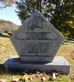
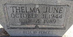
Thelma June Burkhammer Daniel
| Birth | : | 31 Oct 1944 |
| Death | : | 4 Jul 1989 |
| Burial | : | Oak Grove Cemetery, Lewis County, USA |
| Coordinate | : | 38.9641390, -80.5326100 |
| Description | : | Provided by Pam Digges FAG#46870549--Abstracted from the obituary published 6 Jul 1989 in The Potomac News: Thelma June Daniel, 47, of Dumfries, died Tuesday, July 4, 1989, at Potomac Hospital from injuries sustained in an automobile accident. Friends may call at the Mountcastle Funeral Home, Dale City, today from 6 to 9 p.m. There will be additional visitation at the Floyd Funeral Home, 402 Main St., Weston, WV Friday from 2 to 4 and 7 to 9 p.m., where services will be held on Saturday at 11 a.m. Burial will be in Oak Grove Cemetery, Weston. |
frequently asked questions (FAQ):
-
Where is Thelma June Burkhammer Daniel's memorial?
Thelma June Burkhammer Daniel's memorial is located at: Oak Grove Cemetery, Lewis County, USA.
-
When did Thelma June Burkhammer Daniel death?
Thelma June Burkhammer Daniel death on 4 Jul 1989 in
-
Where are the coordinates of the Thelma June Burkhammer Daniel's memorial?
Latitude: 38.9641390
Longitude: -80.5326100
Family Members:
Parent

Siblings
Flowers:


Nearby Cemetories:
1. Oak Grove Cemetery
Lewis County, USA
Coordinate: 38.9641390, -80.5326100
2. Bailey Cemetery
Weston, Lewis County, USA
Coordinate: 38.9759270, -80.5286020
3. Swecker Cemetery
Roanoke, Lewis County, USA
Coordinate: 38.9428950, -80.5282380
4. Rockford-Pletcher Cemetery (Defunct)
Lewis County, USA
Coordinate: 38.9817009, -80.4963989
5. Saint Bridget's Church Cemetery
Weston, Lewis County, USA
Coordinate: 38.9319400, -80.5572970
6. Briar Point Cemetery
Walkersville, Lewis County, USA
Coordinate: 38.9438170, -80.4905950
7. Paul T Mitchell Cemetery
Roanoke, Lewis County, USA
Coordinate: 38.9437210, -80.4905340
8. Ward Cemetery
Lewis County, USA
Coordinate: 38.9975860, -80.5051990
9. Fairview Cemetery
Roanoke, Lewis County, USA
Coordinate: 38.9306000, -80.4847000
10. Whitesell Cemetery
Lewis County, USA
Coordinate: 38.9307760, -80.4844406
11. Harrison Grove Cemetery
Lewis County, USA
Coordinate: 39.0107994, -80.5586014
12. Middle Run Cemetery
Weston, Lewis County, USA
Coordinate: 39.0149994, -80.5081024
13. Saint Bernard Church Cemetery
Weston, Lewis County, USA
Coordinate: 38.9928000, -80.5926940
14. Montgomery Cemetery
Bealls Mills, Lewis County, USA
Coordinate: 38.9648890, -80.6035400
15. Finster Chapel Cemetery
Peterson, Lewis County, USA
Coordinate: 38.9300003, -80.5999985
16. William L. Smith Cemetery
Roanoke, Lewis County, USA
Coordinate: 38.9228820, -80.4715130
17. Queen Family Cemetery
Copley, Lewis County, USA
Coordinate: 38.9499000, -80.6130000
18. Brownsville Cemetery
Lewis County, USA
Coordinate: 39.0163994, -80.4756012
19. Fisher Cemetery
Weston, Lewis County, USA
Coordinate: 39.0331001, -80.5239029
20. Peterson Village Cemetery
Peterson, Lewis County, USA
Coordinate: 38.8938270, -80.5400510
21. Henry Cemetery
Camden, Lewis County, USA
Coordinate: 39.0292350, -80.5751540
22. Glady Cemetery
Horner, Lewis County, USA
Coordinate: 38.9846992, -80.4389038
23. Jacksonville Cemetery
Weston, Lewis County, USA
Coordinate: 38.8919890, -80.4935740
24. Pumphrey Cemetery
Orlando, Lewis County, USA
Coordinate: 38.9275880, -80.6216500