
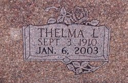
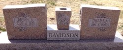
Thelma L. Brockway Davidson
| Birth | : | 3 Sep 1910 Barnard, Lincoln County, Kansas, USA |
| Death | : | 6 Jan 2003 Glasco, Cloud County, Kansas, USA |
| Burial | : | Glasco Cemetery, Glasco, Cloud County, USA |
| Coordinate | : | 39.3574000, -97.8265000 |
| Plot | : | 116W30 |
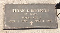
| Description | : | Cloud County Cemetery Book, Volume 4, Page 120 Married 19 May 1945 *********************** Link to a spouse and maiden name sent by Rainbow (#47002487) *********************** Glasco Sun, Thursday, Jan. 9, 2003, page 2: Thelma L. Davidson Died January 6, 2003 Thelma L. Davidson, 92, died January 6, 2003, at the Nicol Home in Glasco, Kansas. Thelma was born September 3, 1910, in Barnard, Kansas to Lew W. Brockway and Naomi Hoskins. She married Glenn L. Prickett in 1933, he died in 1943. She later married Bryan R. Davidson in 1945. He died in 1985. She graduated from Barnard High School in Barnard, Kansas... Read More |
frequently asked questions (FAQ):
-
Where is Thelma L. Brockway Davidson's memorial?
Thelma L. Brockway Davidson's memorial is located at: Glasco Cemetery, Glasco, Cloud County, USA.
-
When did Thelma L. Brockway Davidson death?
Thelma L. Brockway Davidson death on 6 Jan 2003 in Glasco, Cloud County, Kansas, USA
-
Where are the coordinates of the Thelma L. Brockway Davidson's memorial?
Latitude: 39.3574000
Longitude: -97.8265000
Family Members:
Flowers:


Nearby Cemetories:
1. Glasco Cemetery
Glasco, Cloud County, USA
Coordinate: 39.3574000, -97.8265000
2. Saint Marys Catholic Cemetery
Glasco, Cloud County, USA
Coordinate: 39.3574000, -97.8245000
3. Simpson Cemetery
Simpson, Mitchell County, USA
Coordinate: 39.3633003, -97.9471970
4. Bethel Cemetery
Meredith Township, Cloud County, USA
Coordinate: 39.3506000, -97.7029000
5. Delphos Cemetery
Delphos, Ottawa County, USA
Coordinate: 39.2778015, -97.7416992
6. Saint Paul Cemetery
Delphos, Ottawa County, USA
Coordinate: 39.2677994, -97.7518997
7. Asherville Cemetery
Asherville, Mitchell County, USA
Coordinate: 39.4205000, -97.9672900
8. Morrison Cemetery
Center Township, Cloud County, USA
Coordinate: 39.4817009, -97.7975006
9. Summit Cemetery
Jamestown, Cloud County, USA
Coordinate: 39.4813200, -97.8628800
10. Green Mound Cemetery
Asherville, Mitchell County, USA
Coordinate: 39.3203011, -97.9858017
11. Coursen Grove Cemetery
Simpson, Mitchell County, USA
Coordinate: 39.3060989, -97.9792023
12. Hall Cemetery
Cloud County, USA
Coordinate: 39.4455986, -97.7033005
13. Saint Peters Cemetery
Miltonvale, Cloud County, USA
Coordinate: 39.3652350, -97.6483570
14. Bell-Bogardus Cemetery
Asherville, Mitchell County, USA
Coordinate: 39.4242410, -97.9919970
15. Bohemian National Cemetery
Ada, Ottawa County, USA
Coordinate: 39.2193870, -97.9054030
16. Wilcox Cemetery
Cloud County, USA
Coordinate: 39.4925003, -97.7313995
17. West Asher Cemetery
Scottsville, Mitchell County, USA
Coordinate: 39.4815000, -97.9661600
18. Baldwin Cemetery
Ottawa County, USA
Coordinate: 39.2061005, -97.9111023
19. Kindel Cemetery
Center Township, Cloud County, USA
Coordinate: 39.4519005, -97.6464005
20. Smith Cemetery
Asherville, Mitchell County, USA
Coordinate: 39.4516690, -98.0098850
21. McBride Cemetery
Beloit, Mitchell County, USA
Coordinate: 39.4808006, -97.9907990
22. Enterprise Cemetery
Cloud County, USA
Coordinate: 39.4230995, -97.6106033
23. Shiloh Cemetery
Beloit, Mitchell County, USA
Coordinate: 39.3574982, -98.0594025
24. Summit Cemetery #3
Macyville, Cloud County, USA
Coordinate: 39.5258330, -97.9194440