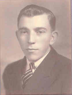
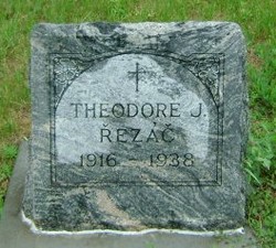
Theodore J. Rezac
| Birth | : | 19 Aug 1916 Weston, Saunders County, Nebraska, USA |
| Death | : | 19 Jun 1938 Saunders County, Nebraska, USA |
| Burial | : | Mount Hope Cemetery, Omaha, Douglas County, USA |
| Coordinate | : | 41.3041992, -96.0310974 |
| Description | : | SEWARD, Neb., June 20 -- Tragedy stalked the Bee Firemen's annual picnic early Sunday morning when Theodore Rezac, 21, of Weston, returning home, was instantly killed when he missed a bend in the road about two miles north of Bee on the Seward and Butler county line. Five companions who were with him were uninjured. According to the other occupants of the car, Theodore, who was driving, jumped from the car when he saw he had failed to make the curve. He was instantly killed. The body was taken to... Read More |
frequently asked questions (FAQ):
-
Where is Theodore J. Rezac's memorial?
Theodore J. Rezac's memorial is located at: Mount Hope Cemetery, Omaha, Douglas County, USA.
-
When did Theodore J. Rezac death?
Theodore J. Rezac death on 19 Jun 1938 in Saunders County, Nebraska, USA
-
Where are the coordinates of the Theodore J. Rezac's memorial?
Latitude: 41.3041992
Longitude: -96.0310974
Family Members:
Parent
Siblings
Flowers:
Nearby Cemetories:
1. Mount Hope Cemetery
Omaha, Douglas County, USA
Coordinate: 41.3041992, -96.0310974
2. Servants of Mary Cemetery
Omaha, Douglas County, USA
Coordinate: 41.3017170, -96.0258260
3. Mount Sinai Cemetery
Omaha, Douglas County, USA
Coordinate: 41.3116989, -96.0314026
4. Springwell Cemetery
Omaha, Douglas County, USA
Coordinate: 41.3114014, -96.0096970
5. All Saints Episcopal Church Columbarium
Omaha, Douglas County, USA
Coordinate: 41.2785000, -96.0579000
6. Potter Field
Omaha, Douglas County, USA
Coordinate: 41.3320274, -95.9902878
7. Forest Lawn Memorial Park
Omaha, Douglas County, USA
Coordinate: 41.3272018, -95.9847031
8. Golden Hill Cemetery
Omaha, Douglas County, USA
Coordinate: 41.3050003, -95.9744034
9. Pleasant Hill Jewish Cemetery
Omaha, Douglas County, USA
Coordinate: 41.3185997, -95.9766998
10. Union Memorial Cemetery
Omaha, Douglas County, USA
Coordinate: 41.3512611, -96.0620193
11. Saint Andrews Episcopal Church Columbarium
Omaha, Douglas County, USA
Coordinate: 41.2492500, -96.0427500
12. Mormon Pioneer Cemetery
Omaha, Douglas County, USA
Coordinate: 41.3348450, -95.9663720
13. Countryside Community Church Columbarium
Omaha, Douglas County, USA
Coordinate: 41.2483660, -96.0500270
14. Nash Chapel Crypt
Omaha, Douglas County, USA
Coordinate: 41.2665090, -95.9721790
15. Holy Sepulchre Cemetery
Omaha, Douglas County, USA
Coordinate: 41.2543983, -95.9875031
16. Prospect Hill Cemetery
Omaha, Douglas County, USA
Coordinate: 41.2780991, -95.9593964
17. Ak-Sar-Ben Racetrack Grounds
Omaha, Douglas County, USA
Coordinate: 41.2414703, -96.0159607
18. Evergreen Memorial Park Cemetery
Omaha, Douglas County, USA
Coordinate: 41.2393990, -96.0355988
19. Calvary Cemetery
Omaha, Douglas County, USA
Coordinate: 41.2364006, -96.0294037
20. First Central Congregational Columbarium
Omaha, Douglas County, USA
Coordinate: 41.2563456, -95.9658365
21. Resurrection Cemetery
Omaha, Douglas County, USA
Coordinate: 41.2344208, -96.0365448
22. Bohemian Cemetery
Omaha, Douglas County, USA
Coordinate: 41.2388992, -95.9955978
23. Westlawn-Hillcrest Memorial Park
Omaha, Douglas County, USA
Coordinate: 41.2346992, -95.9966965
24. Douglas County Poor Farm Cemetery
Omaha, Douglas County, USA
Coordinate: 41.2437240, -95.9723480

