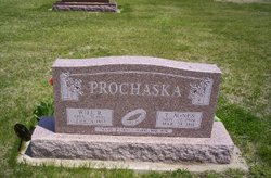
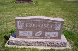
Theresa Agnes Clark Prochaska
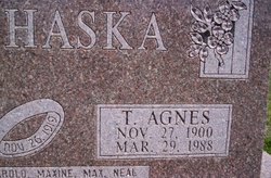
| Birth | : | 27 Nov 1900 Glasco, Cloud County, Kansas, USA |
| Death | : | 29 Mar 1988 Topeka, Shawnee County, Kansas, USA |
| Burial | : | Clayton Village Cemetery, Clayton, Jefferson County, USA |
| Coordinate | : | 44.2268200, -76.0769100 |
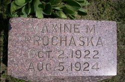
| Inscription | : | Married Nov. 26, 1919 Parents of Harold, Maxine, Max, Neal |
frequently asked questions (FAQ):
-
Where is Theresa Agnes Clark Prochaska's memorial?
Theresa Agnes Clark Prochaska's memorial is located at: Clayton Village Cemetery, Clayton, Jefferson County, USA.
-
When did Theresa Agnes Clark Prochaska death?
Theresa Agnes Clark Prochaska death on 29 Mar 1988 in Topeka, Shawnee County, Kansas, USA
-
Where are the coordinates of the Theresa Agnes Clark Prochaska's memorial?
Latitude: 44.2268200
Longitude: -76.0769100
Family Members:
Parent
Spouse
Siblings
Children
Flowers:
Nearby Cemetories:
1. Clayton Village Cemetery
Clayton, Jefferson County, USA
Coordinate: 44.2268200, -76.0769100
2. Saint Mary's Cemetery
Clayton, Jefferson County, USA
Coordinate: 44.2261100, -76.0761400
3. Spicer Bay Cemetery
Frontenac, Jefferson County, USA
Coordinate: 44.2534700, -76.0374600
4. Clayton Center Cemetery
Clayton Center, Jefferson County, USA
Coordinate: 44.1918700, -76.0402800
5. Saint John's Cemetery
Jefferson County, USA
Coordinate: 44.2206001, -75.9811020
6. Saint John's Cemetery
La Fargeville, Jefferson County, USA
Coordinate: 44.2205518, -75.9806575
7. Grindstone Island Lower Cemetery
Clayton, Jefferson County, USA
Coordinate: 44.2928710, -76.1167250
8. Grindstone Island Cemetery
Clayton, Jefferson County, USA
Coordinate: 44.2808200, -76.1454000
9. Corbin Cemetery
Jefferson County, USA
Coordinate: 44.1528015, -76.0757980
10. Three Mile Creek Cemetery
Clayton, Jefferson County, USA
Coordinate: 44.1533012, -76.1085968
11. Dutch Gap Lutheran Cemetery
Jefferson County, USA
Coordinate: 44.1627998, -76.0083008
12. Epps Settlement Cemetery
Clayton, Jefferson County, USA
Coordinate: 44.1627700, -76.0083500
13. Beech Ridge Cemetery
Jefferson County, USA
Coordinate: 44.2167015, -75.9633026
14. Grove Cemetery
La Fargeville, Jefferson County, USA
Coordinate: 44.1857986, -75.9736023
15. Omar Cemetery
Alexandria Center, Jefferson County, USA
Coordinate: 44.2569008, -75.9642029
16. New Depauville Memorial Cemetery
Depauville, Jefferson County, USA
Coordinate: 44.1397200, -76.0653300
17. Old Depauville Cemetery
Depauville, Jefferson County, USA
Coordinate: 44.1383300, -76.0630600
18. Sand Bay Cemetery
Cape Vincent, Jefferson County, USA
Coordinate: 44.1921997, -76.2078018
19. Hinman Cemetery
Jefferson County, USA
Coordinate: 44.2468987, -75.9336014
20. Saint Lawrence Union Cemetery
Cape Vincent, Jefferson County, USA
Coordinate: 44.1589012, -76.1952972
21. Riverside Cemetery
Alexandria, Jefferson County, USA
Coordinate: 44.3125000, -75.9677963
22. Dodge Bay Cemetery
Millen Bay, Jefferson County, USA
Coordinate: 44.1824100, -76.2273200
23. Saint Lawrence United Church Cemetery
Wolfe Island, Frontenac County, Canada
Coordinate: 44.2085080, -76.2400620
24. Harris Cemetery
Chaumont, Jefferson County, USA
Coordinate: 44.1156006, -76.1539001

