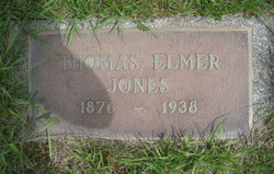
Thomas Elmer Jones
| Birth | : | 1876 Missouri, USA |
| Death | : | 8 Sep 1937 Ellensburg, Kittitas County, Washington, USA |
| Burial | : | Goodrich Cemetery, Goodrich, Sheridan County, USA |
| Coordinate | : | 47.4716988, -100.1406021 |
| Description | : | OBIT: Death came to Thomas E. Jones, 63, at his home east of Ellensburg on Wednesday night. Jones had moved to Ellensburg two and one-half years ago and had been farming the Ralph Kinkade place nine miles east of town. He was born in Missouri in 1874, and came to the coast 35 years ago. He is survived by his wife and six children, Alfred and Evard Jones of Ellensburg; Marion Jones of Cathlamet, and Doris Ann, Lyle and Loyal Jones of Ellensburg. Funeral arrangements will be announced later. Ellensburg Capital, Sep. 10, 1937, pg 1. |
frequently asked questions (FAQ):
-
Where is Thomas Elmer Jones's memorial?
Thomas Elmer Jones's memorial is located at: Goodrich Cemetery, Goodrich, Sheridan County, USA.
-
When did Thomas Elmer Jones death?
Thomas Elmer Jones death on 8 Sep 1937 in Ellensburg, Kittitas County, Washington, USA
-
Where are the coordinates of the Thomas Elmer Jones's memorial?
Latitude: 47.4716988
Longitude: -100.1406021
Family Members:
Spouse
Children
Flowers:
Nearby Cemetories:
1. Goodrich Cemetery
Goodrich, Sheridan County, USA
Coordinate: 47.4716988, -100.1406021
2. Goodrich Seventh-Day Adventist Cemetery
Goodrich, Sheridan County, USA
Coordinate: 47.4803200, -100.1402969
3. Denhoff Catholic Cemetery
Denhoff, Sheridan County, USA
Coordinate: 47.4853247, -100.2673544
4. Denhoff Cemetery
Denhoff, Sheridan County, USA
Coordinate: 47.4839973, -100.2679291
5. Denhoff Adventist Cemetery
Sheridan County, USA
Coordinate: 47.4197006, -100.2446976
6. Saint Jacobus Lutheran Cemetery
Sheridan County, USA
Coordinate: 47.5739100, -100.1917600
7. Fairview Cemetery
Sheridan County, USA
Coordinate: 47.6032982, -100.1502991
8. First German Baptist Church Cemetery
McClusky, Sheridan County, USA
Coordinate: 47.4450684, -100.3536987
9. Pleasant Hill Cemetery
Hurdsfield, Wells County, USA
Coordinate: 47.4364014, -99.9274979
10. Hazel Grove Cemetery
Wing, Burleigh County, USA
Coordinate: 47.3150940, -100.1690700
11. Stark Mennonite Church Cemetery
Wing, Burleigh County, USA
Coordinate: 47.3153800, -100.1770700
12. Zion Cemetery
Sheridan County, USA
Coordinate: 47.6493988, -100.0755997
13. Saint Emanuel Evangelical Lutheran Cemetery
Sheridan County, USA
Coordinate: 47.6594009, -100.2247009
14. McClusky City Cemetery
McClusky, Sheridan County, USA
Coordinate: 47.4801178, -100.4373550
15. Holy Family Catholic Cemetery
McClusky, Sheridan County, USA
Coordinate: 47.4807854, -100.4375076
16. Lincoln Valley Seventh-Day Adventist Cemetery
Lincoln Valley, Sheridan County, USA
Coordinate: 47.6179466, -100.3515167
17. Lincoln Valley Baptist Cemetery
Lincoln Valley, Sheridan County, USA
Coordinate: 47.6469688, -100.2972870
18. Hope Mennonite Cemetery
Wells County, USA
Coordinate: 47.5307999, -99.8422012
19. Saint Petri Lutheran Cemetery
Harvey, Wells County, USA
Coordinate: 47.6176020, -99.9048720
20. Eigenheim Cemetery
Harvey, Wells County, USA
Coordinate: 47.6175620, -99.9046900
21. Hieb-Huft Cemetery
McClusky, Sheridan County, USA
Coordinate: 47.6029100, -100.3952700
22. Harvey Mennonite Brethren Cemetery
Harvey, Wells County, USA
Coordinate: 47.6739006, -100.0260010
23. Chaseley Cemetery
Wells County, USA
Coordinate: 47.4571991, -99.8191986
24. Lincoln Valley Lutheran Cemetery
Lincoln Valley, Sheridan County, USA
Coordinate: 47.6722527, -100.3097916


