
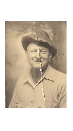
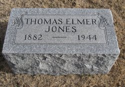
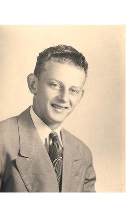
Thomas Elmer Jones
| Birth | : | 4 Apr 1882 Sarcoxie, Jasper County, Missouri, USA |
| Death | : | 21 Mar 1944 Winfield, Cowley County, Kansas, USA |
| Burial | : | Randolph Memorial Park, Asheboro, Randolph County, USA |
| Coordinate | : | 35.7793999, -79.8071976 |
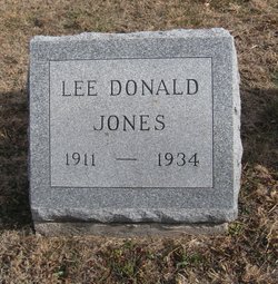
| Description | : | Thomas Elmer Jones, 61, died Tuesday March 21, 1944 in Winfield, Kansas. He was the youngest of six children born on April 04, 1882 in Sarcoxie, Missouri to Thomas A. and Verlinder (Archer) Jones. Elmer was united in marriage to Effie Opal Logsdon on April 24, 1910 at her father's home in Grenola, Kansas. Of that marriage six children were born. In order of their births their names are: Lee Donald, Eleanor Irene, Margueritte Louise, George Darrell, Lois Elaine, and Kenneth Dwain. Elmer and Opal owned and operated the Cream Station and Feed Store in Grenola from 1937 to... Read More |
frequently asked questions (FAQ):
-
Where is Thomas Elmer Jones's memorial?
Thomas Elmer Jones's memorial is located at: Randolph Memorial Park, Asheboro, Randolph County, USA.
-
When did Thomas Elmer Jones death?
Thomas Elmer Jones death on 21 Mar 1944 in Winfield, Cowley County, Kansas, USA
-
Where are the coordinates of the Thomas Elmer Jones's memorial?
Latitude: 35.7793999
Longitude: -79.8071976
Family Members:
Parent

Spouse
Siblings
Children
Flowers:


Nearby Cemetories:
1. Randolph Memorial Park
Asheboro, Randolph County, USA
Coordinate: 35.7793999, -79.8071976
2. Davis Chapel Methodist Protestant Church Cemetery
Asheboro, Randolph County, USA
Coordinate: 35.7836070, -79.8268640
3. Whitehall Evangelical Methodist Church Cemetery
Randleman, Randolph County, USA
Coordinate: 35.7950100, -79.8153900
4. Country Holiness Cemetery
Randleman, Randolph County, USA
Coordinate: 35.8016800, -79.8016900
5. Liberty Road Baptist Church Cemetery
Randleman, Randolph County, USA
Coordinate: 35.7715500, -79.7808130
6. Midway Wesleyan Church Cemetery
Randleman, Randolph County, USA
Coordinate: 35.8018900, -79.8006990
7. Neighbors Grove Wesleyan Church Cemetery
Asheboro, Randolph County, USA
Coordinate: 35.7509200, -79.8045030
8. Harshaw Grove Missionary Baptist Church Cemetery
Randleman, Randolph County, USA
Coordinate: 35.8051670, -79.8265100
9. J. E. Groce Memorial Cemetery
Worthville, Randolph County, USA
Coordinate: 35.8032620, -79.7813460
10. God Outreach Ministries Cemetery
Asheboro, Randolph County, USA
Coordinate: 35.7473240, -79.7890130
11. Baileys Grove Baptist Church Cemetery
Asheboro, Randolph County, USA
Coordinate: 35.7404060, -79.8075610
12. Ferree's Chapel Cemetery
Randleman, Randolph County, USA
Coordinate: 35.8189700, -79.8108000
13. Giles Chapel United Methodist Church Cemetery
Asheboro, Randolph County, USA
Coordinate: 35.7462270, -79.7752450
14. Saint Paul Methodist Episcopal South Cemetery
Randleman, Randolph County, USA
Coordinate: 35.8222200, -79.8090410
15. Trinity Holiness Church Cemetery
Sophia, Randolph County, USA
Coordinate: 35.8146050, -79.8427561
16. South Plainfield Friends Meeting Cemetery
Sophia, Randolph County, USA
Coordinate: 35.7952900, -79.8607840
17. Mount Lebanon United Methodist Church Cemetery
Randleman, Randolph County, USA
Coordinate: 35.8267230, -79.8039770
18. Bethany United Methodist Church Cemetery #1
Franklinville, Randolph County, USA
Coordinate: 35.8101300, -79.7606200
19. John Wesley Stand Cemetery
Sophia, Randolph County, USA
Coordinate: 35.7726220, -79.8670520
20. Faith Temple Baptist Church Cemetery
Franklinville, Randolph County, USA
Coordinate: 35.8023770, -79.7460950
21. New Salem United Methodist Church Cemetery
Randleman, Randolph County, USA
Coordinate: 35.8406311, -79.7853233
22. Odell Trogdon Cemetery
Grays Chapel, Randolph County, USA
Coordinate: 35.7947200, -79.7300200
23. Cedar Falls Baptist Church Cemetery
Cedar Falls, Randolph County, USA
Coordinate: 35.7480800, -79.7357800
24. Episcopal Church of Good Shepherd Memorial Garden
Asheboro, Randolph County, USA
Coordinate: 35.7152410, -79.8327260