
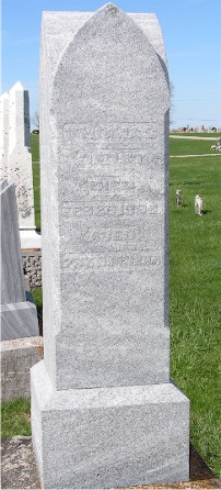
Thomas Garst
| Birth | : | 15 Jun 1815 Virginia, USA |
| Death | : | 23 Feb 1889 |
| Burial | : | Hillside Cemetery, Osterville, Barnstable County, USA |
| Coordinate | : | 41.6316700, -70.3787100 |
| Description | : | He married Elizabeth Brubaker November 11th, 1841 in Roanoke County, Virginia. He was the son of Elizabeth Garst. Sibling of Elizabeth and Catherine. He was also the father of Henry, Sarah, George, Elizabeth Jane, and Mary E. ------------- (From "History of Wabash County, Indiana" pub. 1884, pg 487) THOMAS GARST, farmer, P.O. Somerset, an early settler and substantial farmer, was born in Roanoke County, Va., June 15, 1815. His education was rather limited in scope; his youth and early manhood were passed upon the home farm. In 1842, Mr. Garst was united in marriage to Miss Elizabeth Brubaker. Mr. and Mrs. Garst are... Read More |
frequently asked questions (FAQ):
-
Where is Thomas Garst's memorial?
Thomas Garst's memorial is located at: Hillside Cemetery, Osterville, Barnstable County, USA.
-
When did Thomas Garst death?
Thomas Garst death on 23 Feb 1889 in
-
Where are the coordinates of the Thomas Garst's memorial?
Latitude: 41.6316700
Longitude: -70.3787100
Family Members:
Spouse

Children
Flowers:


Nearby Cemetories:
1. Hillside Cemetery
Osterville, Barnstable County, USA
Coordinate: 41.6316700, -70.3787100
2. Saint Peters Episcopal Church Memorial Garden
Barnstable, Barnstable County, USA
Coordinate: 41.6209700, -70.3735800
3. Congregational Cemetery
Barnstable, Barnstable County, USA
Coordinate: 41.6459007, -70.3461990
4. Beechwood Cemetery
Centerville, Barnstable County, USA
Coordinate: 41.6561012, -70.3491974
5. Centerville Ancient Cemetery
Centerville, Barnstable County, USA
Coordinate: 41.6547012, -70.3429031
6. Marstons Mills Cemetery
Marstons Mills, Barnstable County, USA
Coordinate: 41.6612015, -70.4080963
7. Mosswood Cemetery
Cotuit, Barnstable County, USA
Coordinate: 41.6279984, -70.4303970
8. Saint Francis Xavier Cemetery
Centerville, Barnstable County, USA
Coordinate: 41.6516991, -70.3331985
9. Saint Andrew's By The Sea Columbarium
Hyannis Port, Barnstable County, USA
Coordinate: 41.6306199, -70.3073859
10. Coombs Cemetery
Mashpee, Barnstable County, USA
Coordinate: 41.6417370, -70.4570980
11. Crocker Park Cemetery
Barnstable, Barnstable County, USA
Coordinate: 41.6959000, -70.3780975
12. South Street Cemetery
Hyannis, Barnstable County, USA
Coordinate: 41.6480300, -70.2920500
13. West Parish Burial Ground
West Barnstable, Barnstable County, USA
Coordinate: 41.6984200, -70.3842920
14. Oak Grove Cemetery
Hyannis, Barnstable County, USA
Coordinate: 41.6432991, -70.2889023
15. Oak Neck Cemetery
Hyannis, Barnstable County, USA
Coordinate: 41.6431007, -70.2861023
16. Baptist Church Cemetery
Hyannis, Barnstable County, USA
Coordinate: 41.6519699, -70.2873230
17. Sandy Street Cemetery
Barnstable, Barnstable County, USA
Coordinate: 41.6968994, -70.3401031
18. Mashpee Town Cemetery
Mashpee, Barnstable County, USA
Coordinate: 41.6242981, -70.4787979
19. Saint Patricks Cemetery
Hyannis, Barnstable County, USA
Coordinate: 41.6562996, -70.2835999
20. Universalist Cemetery
Hyannis, Barnstable County, USA
Coordinate: 41.6549100, -70.2822390
21. West Barnstable Cemetery
West Barnstable, Barnstable County, USA
Coordinate: 41.7080994, -70.3728027
22. Lakewood Cemetery
Mashpee, Barnstable County, USA
Coordinate: 41.6530991, -70.4783020
23. Boardley Road Cemetery
Sandwich, Barnstable County, USA
Coordinate: 41.6870003, -70.4559021
24. Percival Cemetery
Sandwich, Barnstable County, USA
Coordinate: 41.6883011, -70.4557037