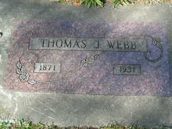
Thomas Jefferson Webb
| Birth | : | 29 Sep 1871 Lawrence County, Kentucky, USA |
| Death | : | 20 Feb 1931 Leavenworth, Chelan County, Washington, USA |
| Burial | : | Laurel Cemetery, Haven, Reno County, USA |
| Coordinate | : | 37.9268990, -97.8394012 |
| Description | : | Washington Death Certificate name: Thomas Jefferson Webb death date: 20 Feb 1931 death place: Leavenworth, Chelan, Washington gender: Male age at death: 60 years 4 months 22 days estimated birth year: 1871 father's name:Geo. W. Webb mother's name:Clarinda White (Whitt) siblings: Henry Webb b: Oct 1860 d: 4 Jan 1861, Levi J Webb b: 22 Dec 1864 d: 29 Oct 1937, Nora Lee Webb Bellott b: 22 Nov 1879 d: 1 Jun 1956 |
frequently asked questions (FAQ):
-
Where is Thomas Jefferson Webb's memorial?
Thomas Jefferson Webb's memorial is located at: Laurel Cemetery, Haven, Reno County, USA.
-
When did Thomas Jefferson Webb death?
Thomas Jefferson Webb death on 20 Feb 1931 in Leavenworth, Chelan County, Washington, USA
-
Where are the coordinates of the Thomas Jefferson Webb's memorial?
Latitude: 37.9268990
Longitude: -97.8394012
Family Members:
Parent
Siblings
Flowers:
Nearby Cemetories:
1. Laurel Cemetery
Haven, Reno County, USA
Coordinate: 37.9268990, -97.8394012
2. Yoder Amish Cemetery
Yoder, Reno County, USA
Coordinate: 37.9412330, -97.8389500
3. Yoder Mennonite Church Cemetery
Yoder, Reno County, USA
Coordinate: 37.9546300, -97.8662800
4. Saint Pauls Lutheran Church Cemetery
Haven, Reno County, USA
Coordinate: 37.8974410, -97.7939490
5. Fairview Cemetery
Elmer, Reno County, USA
Coordinate: 37.9631004, -97.9021988
6. Valley Township Cemetery
Haven, Reno County, USA
Coordinate: 37.9491550, -97.7474530
7. Haven Priest Cemetery
Haven, Reno County, USA
Coordinate: 37.8685989, -97.7457962
8. Pleasant View Cemetery
Darlow, Reno County, USA
Coordinate: 37.9248520, -97.9768280
9. Star Cemetery
Patterson, Harvey County, USA
Coordinate: 37.9263687, -97.6833878
10. Fairlawn Burial Park
Hutchinson, Reno County, USA
Coordinate: 38.0457993, -97.8867035
11. Reformatory Cemetery
Hutchinson, Reno County, USA
Coordinate: 38.0433430, -97.9042120
12. Hutchinson Eastside Cemetery
Hutchinson, Reno County, USA
Coordinate: 38.0461006, -97.9152985
13. Hunt Cemetery
Patterson, Harvey County, USA
Coordinate: 37.9413000, -97.6657000
14. First Presbyterian Church Columbarium
Hutchinson, Reno County, USA
Coordinate: 38.0521950, -97.9279430
15. Saint Agnes Cemetery
Reno County, USA
Coordinate: 37.8325005, -97.9792023
16. Plainview Mennonite Church Cemetery
Partridge, Reno County, USA
Coordinate: 37.9702700, -98.0174100
17. Maranatha Mennonite Church Cemetery
Hutchinson, Reno County, USA
Coordinate: 38.0211525, -97.9841614
18. Mount Hope Cemetery
Mount Hope, Sedgwick County, USA
Coordinate: 37.8546982, -97.6744003
19. Amish Community Cemetery
Hutchinson, Reno County, USA
Coordinate: 37.9841320, -98.0224329
20. Burrton Cemetery
Burrton, Harvey County, USA
Coordinate: 38.0150757, -97.6750793
21. First Mennonite Church Columbarium
Hutchinson, Reno County, USA
Coordinate: 38.0771100, -97.9088600
22. Trinity United Methodist Church Columbarium
Hutchinson, Reno County, USA
Coordinate: 38.0713200, -97.9314440
23. Antioch Cemetery
Reno County, USA
Coordinate: 37.7850490, -97.7360050
24. Lone Star Cemetery
Pretty Prairie, Reno County, USA
Coordinate: 37.8074989, -97.9822006


