
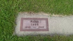

Thor Sunde
| Birth | : | 30 Mar 1885 Gardner Township, Sangamon County, Illinois, USA |
| Death | : | 29 Jul 1948 Estherville, Emmet County, Iowa, USA |
| Burial | : | Palestine Cemetery, Dolliver, Emmet County, USA |
| Coordinate | : | 43.4880000, -94.6408000 |
| Description | : | Thor Sunde Dies Following Illness of One Year Death came this morning at four o'clock to Thor Sunde, a life long resident of the county. Mr. Sunde had been ill for over a year. He underwent an operation at Rochester in April of last year for a brain tumor. He has been at home since that time but his health seemed to be failing. He has been in Park View Clinic for two weeks but his condition was very serious when taken there. Mr. Sunde was well known in this vicinity. He held the respect of those who knew him. He was a... Read More |
frequently asked questions (FAQ):
-
Where is Thor Sunde's memorial?
Thor Sunde's memorial is located at: Palestine Cemetery, Dolliver, Emmet County, USA.
-
When did Thor Sunde death?
Thor Sunde death on 29 Jul 1948 in Estherville, Emmet County, Iowa, USA
-
Where are the coordinates of the Thor Sunde's memorial?
Latitude: 43.4880000
Longitude: -94.6408000
Family Members:
Parent

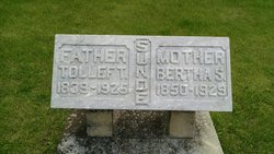
Spouse
Siblings
Children
Flowers:


Nearby Cemetories:
1. Palestine Cemetery
Dolliver, Emmet County, USA
Coordinate: 43.4880000, -94.6408000
2. Lincoln Township Cemetery
Dolliver, Emmet County, USA
Coordinate: 43.4441986, -94.6204987
3. Lake Belt Cemetery
Ceylon, Martin County, USA
Coordinate: 43.5353012, -94.6742020
4. Tenhassen Cemetery
Ceylon, Martin County, USA
Coordinate: 43.5293999, -94.5877991
5. Ellsworth Cemetery
Emmet County, USA
Coordinate: 43.5005989, -94.7249985
6. German Evangelical Cemetery
Wilbert, Martin County, USA
Coordinate: 43.5325600, -94.5419000
7. Saint Pauls Lutheran Church Cemetery
Wilbert, Martin County, USA
Coordinate: 43.5444500, -94.5395800
8. Swan Lake Township Cemetery
Maple Hill, Emmet County, USA
Coordinate: 43.3850746, -94.6381378
9. Prosser Cemetery
Estherville, Emmet County, USA
Coordinate: 43.4422000, -94.7783000
10. Lake Fremont Cemetery
Dunnell, Martin County, USA
Coordinate: 43.5691986, -94.7746964
11. Center Township Cemetery
Emmet County, USA
Coordinate: 43.3608000, -94.6790000
12. Armstrong Grove Cemetery
Armstrong, Emmet County, USA
Coordinate: 43.3985696, -94.5041425
13. Saint Marys Catholic Cemetery
Armstrong, Emmet County, USA
Coordinate: 43.3980000, -94.5048000
14. Lone Cedar Cemetery
Sherburn, Martin County, USA
Coordinate: 43.6166992, -94.7144012
15. Mount Calvary Cemetery
Armstrong, Emmet County, USA
Coordinate: 43.3850000, -94.5028000
16. Center Chain Cemetery
Martin County, USA
Coordinate: 43.5224991, -94.4483032
17. Estherville Lutheran Cemetery
Estherville, Emmet County, USA
Coordinate: 43.4298000, -94.8263000
18. Norwegian Cemetery
Estherville, Emmet County, USA
Coordinate: 43.4291992, -94.8261032
19. East Side Memorial Cemetery
Estherville, Emmet County, USA
Coordinate: 43.4267750, -94.8265600
20. East Side Cemetery
Estherville, Emmet County, USA
Coordinate: 43.4068985, -94.8264008
21. Sherburn Cemetery
Sherburn, Martin County, USA
Coordinate: 43.6455612, -94.7275009
22. Saint Patricks Cemetery
Estherville, Emmet County, USA
Coordinate: 43.3843994, -94.8283005
23. Saint Lukes Cemetery
Sherburn, Martin County, USA
Coordinate: 43.6530120, -94.7133132
24. Oak Hill Cemetery
Estherville, Emmet County, USA
Coordinate: 43.3986015, -94.8518982