
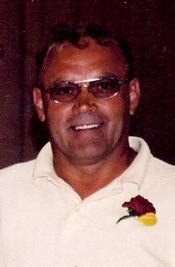
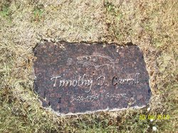
Timothy Duane “Tim” Carroll
| Birth | : | 24 Mar 1956 Pierre, Hughes County, South Dakota, USA |
| Death | : | 5 Jun 2012 Pierre, Hughes County, South Dakota, USA |
| Burial | : | Scotty Philip Cemetery, Fort Pierre, Stanley County, USA |
| Coordinate | : | 44.4019012, -100.4036026 |
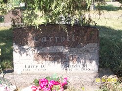
| Description | : | Timothy Carroll, 56 of Pierre, died Tuesday, June 5 at St. Mary's Hospital after a several year battle with cancer. Timothy Duane Carroll was born on March 24, 1956 to Larry and Suzan (Mehrer) Carroll in Pierre. He grew up in the Pierre and Ft. Pierre area where he attended school and graduated from Stanley County High School. He worked with his family at the family-owned Texaco Station. After graduation, Tim pursued a life of carpentry. He met and married Deborah Bryan. In addition to Deb's son, Jade Frederick, four more children were born to this union: Shawna, Tamara, Dusty and... Read More |
frequently asked questions (FAQ):
-
Where is Timothy Duane “Tim” Carroll's memorial?
Timothy Duane “Tim” Carroll's memorial is located at: Scotty Philip Cemetery, Fort Pierre, Stanley County, USA.
-
When did Timothy Duane “Tim” Carroll death?
Timothy Duane “Tim” Carroll death on 5 Jun 2012 in Pierre, Hughes County, South Dakota, USA
-
Where are the coordinates of the Timothy Duane “Tim” Carroll's memorial?
Latitude: 44.4019012
Longitude: -100.4036026
Family Members:
Parent
Flowers:


Nearby Cemetories:
1. Scotty Philip Cemetery
Fort Pierre, Stanley County, USA
Coordinate: 44.4019012, -100.4036026
2. Fort Pierre Chouteau Cemetery
Fort Pierre, Stanley County, USA
Coordinate: 44.3908700, -100.3878300
3. Mount Calvary Cemetery
Pierre, Hughes County, USA
Coordinate: 44.4197006, -100.3557968
4. South Dakota State Capitol Grounds
Pierre, Hughes County, USA
Coordinate: 44.3660100, -100.3448000
5. Cedar Hill Cemetery
Fort Pierre, Stanley County, USA
Coordinate: 44.3356018, -100.3964005
6. Riverside Cemetery
Pierre, Hughes County, USA
Coordinate: 44.3608017, -100.3071976
7. Byron Township Cemetery
Blunt, Hughes County, USA
Coordinate: 44.4979200, -100.1904700
8. Fort Sully Post Cemetery
Sully County, USA
Coordinate: 44.5866480, -100.6087530
9. Meers Cemetery
Stanley County, USA
Coordinate: 44.4116970, -100.7360760
10. Mathews Family Cemetery
Stanley County, USA
Coordinate: 44.1816040, -100.5581080
11. Okobojo Cemetery
Sully County, USA
Coordinate: 44.6568985, -100.3647003
12. Canning Cemetery
Hughes County, USA
Coordinate: 44.3986890, -100.0278460
13. Holy Name Episcopal Cemetery
Fort Pierre, Stanley County, USA
Coordinate: 44.2694960, -100.0357300
14. Holy Name Chapel Cemetery
Fort Pierre, Stanley County, USA
Coordinate: 44.2694292, -100.0356989
15. Pleasant Hill Cemetery
Blunt, Hughes County, USA
Coordinate: 44.5135994, -100.0156021
16. Fort Bennett Post Cemetery
Stanley County, USA
Coordinate: 44.6716500, -100.6404200
17. Immanuel Lutheran Cemetery
Van Metre, Jones County, USA
Coordinate: 44.0958800, -100.7263300
18. Mission Ridge Cemetery
Mission Ridge, Stanley County, USA
Coordinate: 44.6960983, -100.7716980
19. Onida Cemetery
Onida, Sully County, USA
Coordinate: 44.7147000, -100.0650000
20. Chapelle Cemetery
Hughes County, USA
Coordinate: 44.3025017, -99.8653030
21. Holy Faith Cemetery
Lyman County, USA
Coordinate: 44.1356010, -99.9878006
22. Blair Cemetery
Sully County, USA
Coordinate: 44.8027992, -100.4199982
23. Sansarc Cemetery
Hayes, Stanley County, USA
Coordinate: 44.5153008, -101.0342026
24. Draper Cemetery
Draper, Jones County, USA
Coordinate: 43.9322014, -100.5475006