
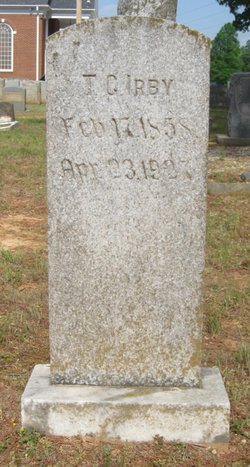
| Birth | : | Oct 1881 Union County, North Carolina, USA |
| Death | : | 11 Feb 1931 Union County, North Carolina, USA |
| Burial | : | Price Chapel Baptist Church Cemetery, Waxhaw, Union County, USA |
| Coordinate | : | 34.9415283, -80.7617188 |
| Description | : | Died in Sandy Ridge Community Daughter of Thomas C Irby & Sarah Darcus Stewart Irby May have had one daughter, Elizabeth Hancock, b. 1926 NC |
frequently asked questions (FAQ):
-
Where is Tina Ella “Tiney” Irby Hancock's memorial?
Tina Ella “Tiney” Irby Hancock's memorial is located at: Price Chapel Baptist Church Cemetery, Waxhaw, Union County, USA.
-
When did Tina Ella “Tiney” Irby Hancock death?
Tina Ella “Tiney” Irby Hancock death on 11 Feb 1931 in Union County, North Carolina, USA
-
Where are the coordinates of the Tina Ella “Tiney” Irby Hancock's memorial?
Latitude: 34.9415283
Longitude: -80.7617188
Family Members:
Parent

Spouse

Siblings
Flowers:


Nearby Cemetories:
1. Price Chapel Baptist Church Cemetery
Waxhaw, Union County, USA
Coordinate: 34.9415283, -80.7617188
2. Providence Baptist Church Cemetery
Waxhaw, Union County, USA
Coordinate: 34.9441200, -80.7547200
3. Eastside Community Cemetery
Waxhaw, Union County, USA
Coordinate: 34.9281883, -80.7384415
4. Waxhaw City Cemetery
Waxhaw, Union County, USA
Coordinate: 34.9182816, -80.7384415
5. Bonds Grove United Methodist Church Cemetery
Waxhaw, Union County, USA
Coordinate: 34.9739609, -80.7715378
6. Our Lady of Grace Catholic Church Cemetery
Indian Land, Lancaster County, USA
Coordinate: 34.9191510, -80.7933580
7. Old Union Methodist Church Cemetery
Union County, USA
Coordinate: 34.9676094, -80.7292023
8. Piney Grove Baptist Church West Cemetery
Waxhaw, Union County, USA
Coordinate: 34.9061356, -80.7312622
9. Center Grove Memorial Park
Indian Land, Lancaster County, USA
Coordinate: 34.9205500, -80.8122100
10. Old Elbethel AME Zion Church Cemetery
Indian Land, Lancaster County, USA
Coordinate: 34.9631250, -80.8125350
11. Waxhaw Baptist Church Cemetery
Waxhaw, Union County, USA
Coordinate: 34.9039001, -80.7251205
12. Redding Springs AME Zion Church Cemetery
Union County, USA
Coordinate: 34.9911919, -80.7594910
13. Old Six Mile Cemetery
Indian Land, Lancaster County, USA
Coordinate: 34.9484250, -80.8220320
14. Union United Methodist Church Cemetery
Union County, USA
Coordinate: 34.9818192, -80.7215424
15. Osceola United Methodist Church Cemetery
Lancaster, Lancaster County, USA
Coordinate: 34.9056920, -80.8091770
16. Rehobeth Presbyterian Church Cemetery
Union County, USA
Coordinate: 34.8881645, -80.7605209
17. Ebenezer AME Zion Church Cemetery
Waxhaw, Union County, USA
Coordinate: 34.8974680, -80.7207480
18. Heath Memorial United Methodist Church Cemetery
Union County, USA
Coordinate: 34.8889046, -80.7834396
19. Six Mile Cemetery
Indian Land, Lancaster County, USA
Coordinate: 34.9308014, -80.8319016
20. Steele Hill AME Zion Church Cemetery
Lancaster, Lancaster County, USA
Coordinate: 34.8898697, -80.7984009
21. Elbethel AME Zion Church Cemetery
Belair, Lancaster County, USA
Coordinate: 34.9626270, -80.8299860
22. Marvin AME Zion Church Cemetery
Waxhaw, Union County, USA
Coordinate: 34.9920000, -80.8040000
23. Thompson Chapel AME Zion Church Cemetery
Mineral Springs, Union County, USA
Coordinate: 34.9279351, -80.6880677
24. Indian Land Baptist Church Cemetery
Indian Land, Lancaster County, USA
Coordinate: 34.9318840, -80.8367260