
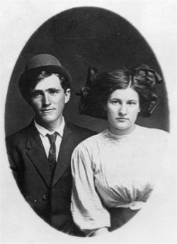
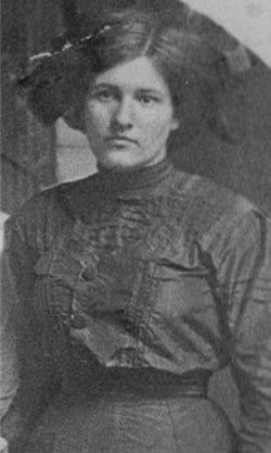
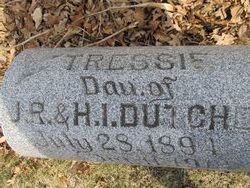
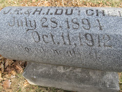
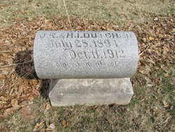
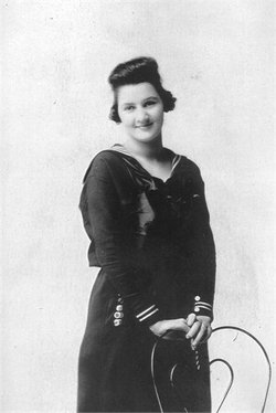
Tressie Mae Dutcher Powell
| Birth | : | 28 Jul 1894 |
| Death | : | 11 Oct 1912 |
| Burial | : | McGuire Bend Cemetery, Dayton, Webster County, USA |
| Coordinate | : | 42.3410000, -93.9880000 |
| Inscription | : | A loved one at rest. |
| Description | : | She married Pearl William Powell 18 Oct 1911 in Lehigh, Webster, Iowa. Tressie died the following year from burns she suffered when her clothing caught fire. ****** Lehigh Valley Argus (Iowa) Thursday, 17 Oct 1912 TERRIBLE DEATH OF MRS. POWELL Uses Kerosene to Light Fire When Can Explodes -- FRIGHTFULLY BURNED Mrs. Frank (should be Pearl, son of Frank) Powell, eighteen years old, was frightfully burned last Thursday and death resulted twenty four hours later. Mrs. Powell had been out of the house part of the day and on returning to the house built a fire... Read More |
frequently asked questions (FAQ):
-
Where is Tressie Mae Dutcher Powell's memorial?
Tressie Mae Dutcher Powell's memorial is located at: McGuire Bend Cemetery, Dayton, Webster County, USA.
-
When did Tressie Mae Dutcher Powell death?
Tressie Mae Dutcher Powell death on 11 Oct 1912 in
-
Where are the coordinates of the Tressie Mae Dutcher Powell's memorial?
Latitude: 42.3410000
Longitude: -93.9880000
Family Members:
Parent
Spouse

Siblings
Flowers:


Nearby Cemetories:
1. McGuire Bend Cemetery
Dayton, Webster County, USA
Coordinate: 42.3410000, -93.9880000
2. Hartman Cemetery
Lehigh, Webster County, USA
Coordinate: 42.3666397, -93.9835627
3. Vegors Cemetery
Webster County, USA
Coordinate: 42.3177986, -93.9421997
4. Ober and Scott Cemetery
Duncombe, Webster County, USA
Coordinate: 42.3841390, -93.9982856
5. Oak Grove Cemetery
Lehigh, Webster County, USA
Coordinate: 42.3438988, -94.0475006
6. Bass Cemetery
Dayton, Webster County, USA
Coordinate: 42.2966995, -94.0149994
7. Blanchard Cemetery
Webster County, USA
Coordinate: 42.4021988, -93.9997025
8. West Lawn Cemetery
Lehigh, Webster County, USA
Coordinate: 42.3616982, -94.0678024
9. Homer Cemetery
Homer, Hamilton County, USA
Coordinate: 42.3680992, -93.9088974
10. Border Plains Cemetery
Border Plains, Webster County, USA
Coordinate: 42.3917000, -94.0448000
11. Hooks Point Cemetery
Hamilton County, USA
Coordinate: 42.2944530, -93.9199090
12. Oakwood Cemetery
Stratford, Hamilton County, USA
Coordinate: 42.2942009, -93.9182968
13. Neese Cemetery
Homer, Hamilton County, USA
Coordinate: 42.3250000, -93.8935000
14. Nesse Cemetery
Hamilton County, USA
Coordinate: 42.3250008, -93.8933029
15. Washington Cemetery
Duncombe, Webster County, USA
Coordinate: 42.4277992, -93.9916992
16. Dayton Cemetery
Dayton, Webster County, USA
Coordinate: 42.2675000, -94.0755000
17. Hardin Township Cemetery
Hardin Township, Webster County, USA
Coordinate: 42.2411003, -93.9708023
18. Christ the King Catholic Cemetery
Dayton, Webster County, USA
Coordinate: 42.2601929, -94.0727539
19. Otho Cemetery
Otho, Webster County, USA
Coordinate: 42.4025002, -94.1153030
20. Saratoga Cemetery
Stanhope, Hamilton County, USA
Coordinate: 42.3539009, -93.8167038
21. Holaday Creek Cemetery
Webster County, USA
Coordinate: 42.4472008, -94.0886002
22. Washington Township Cemetery
Duncombe, Webster County, USA
Coordinate: 42.4707900, -94.0002000
23. Linn Cemetery
Pilot Mound, Boone County, USA
Coordinate: 42.2045330, -93.9970230
24. South Marion Cemetery
Stratford, Hamilton County, USA
Coordinate: 42.2327995, -93.8735962