
Ulysses Grant Gooderham
| Birth | : | 13 Mar 1894 Huntington, Cabell County, West Virginia, USA |
| Death | : | 15 Apr 1957 Huntington, Cabell County, West Virginia, USA |
| Burial | : | St. John the Baptist Churchyard, Hinton Charterhouse, Bath and North East Somerset Unitary Authority, England |
| Coordinate | : | 51.3233330, -2.3219440 |
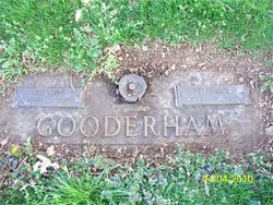
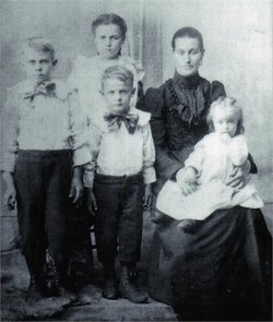
| Description | : | Ulysses Grant Gooderham was born on March 13, 1894 to William Thomas Jackson Gooderham and Missouria Dewitt Gooderham in Huntington, Cabell County. He lived his entire life in Cabell County and met and married his first wife, Lottie Ray on June 19, 1914 at the age of 20. Grant and Lottie were blessed with five children:Willard, Ezra, Susie, Eva, and Allie Benson. On April 15, 1957, Grant was crushed by a cemetery vault and died in Huntington. |
frequently asked questions (FAQ):
-
Where is Ulysses Grant Gooderham's memorial?
Ulysses Grant Gooderham's memorial is located at: St. John the Baptist Churchyard, Hinton Charterhouse, Bath and North East Somerset Unitary Authority, England.
-
When did Ulysses Grant Gooderham death?
Ulysses Grant Gooderham death on 15 Apr 1957 in Huntington, Cabell County, West Virginia, USA
-
Where are the coordinates of the Ulysses Grant Gooderham's memorial?
Latitude: 51.3233330
Longitude: -2.3219440
Family Members:
Spouse


Children
Flowers:


Nearby Cemetories:
1. St. John the Baptist Churchyard
Hinton Charterhouse, Bath and North East Somerset Unitary Authority, England
Coordinate: 51.3233330, -2.3219440
2. Freshford Cemetery
Freshford, Bath and North East Somerset Unitary Authority, England
Coordinate: 51.3379620, -2.3082970
3. Midford Burial Ground
Bath, Bath and North East Somerset Unitary Authority, England
Coordinate: 51.3394360, -2.3391424
4. Saint Peters Churchyard
Freshford, Bath and North East Somerset Unitary Authority, England
Coordinate: 51.3400570, -2.3033340
5. St Leonard Churchyard
Farleigh Hungerford, Mendip District, England
Coordinate: 51.3155390, -2.2884820
6. Farleigh Hungerford Castle
Farleigh Hungerford, Mendip District, England
Coordinate: 51.3173500, -2.2869590
7. Norton St. Philip Churchyard
Norton St Philip, Mendip District, England
Coordinate: 51.3001680, -2.3279700
8. St Julian's Churchyard
Wellow, Bath and North East Somerset Unitary Authority, England
Coordinate: 51.3240160, -2.3717630
9. All Saints Churchyard
Tellisford, Mendip District, England
Coordinate: 51.2997270, -2.2877180
10. St. Michael's Churchyard
Monkton Combe, Bath and North East Somerset Unitary Authority, England
Coordinate: 51.3559540, -2.3285700
11. St. James' Churchyard
South Stoke, Bath and North East Somerset Unitary Authority, England
Coordinate: 51.3497220, -2.3652780
12. Union Chapel
Combe Down, Bath and North East Somerset Unitary Authority, England
Coordinate: 51.3594751, -2.3443662
13. Combe Hay Parish Churchyard
Combe Hay, Bath and North East Somerset Unitary Authority, England
Coordinate: 51.3371120, -2.3817390
14. St. Lawrence Churchyard
Woolverton, Mendip District, England
Coordinate: 51.2851540, -2.3021790
15. Combe Hay Cemetery
Combe Hay, Bath and North East Somerset Unitary Authority, England
Coordinate: 51.3397819, -2.3814323
16. Jewish Burial Ground
Combe Down, Bath and North East Somerset Unitary Authority, England
Coordinate: 51.3599170, -2.3534670
17. Prior Park College
Bath, Bath and North East Somerset Unitary Authority, England
Coordinate: 51.3645990, -2.3442400
18. Wellow & Shoscombe Cemetery
Wellow, Bath and North East Somerset Unitary Authority, England
Coordinate: 51.3165527, -2.3916632
19. Christ Church Churchyard
Rode, Mendip District, England
Coordinate: 51.2861620, -2.2790890
20. Bath Union Workhouse Graveyard
Bath, Bath and North East Somerset Unitary Authority, England
Coordinate: 51.3584160, -2.3711140
21. St Mary's Churchyard
Laverton, Mendip District, England
Coordinate: 51.2757380, -2.3195910
22. Bath Union Workhouse Burial Ground
Bath, Bath and North East Somerset Unitary Authority, England
Coordinate: 51.3570889, -2.3773370
23. Holy Trinity Churchyard
Bradford-on-Avon, Wiltshire Unitary Authority, England
Coordinate: 51.3465927, -2.2538147
24. St John the Evangelist Cemetery
Bath, Bath and North East Somerset Unitary Authority, England
Coordinate: 51.3696700, -2.3487400