

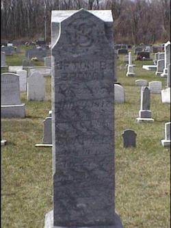
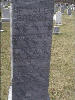
Upton B. Brown
| Birth | : | 28 Jan 1855 Lantz, Frederick County, Maryland, USA |
| Death | : | 31 Mar 1917 Baltimore, Baltimore City, Maryland, USA |
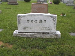
| Burial | : | Elliston Cemetery, Elliston, Powell County, USA |
| Coordinate | : | 46.5693090, -112.4406270 |
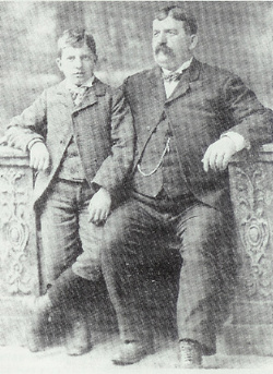
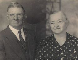
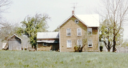
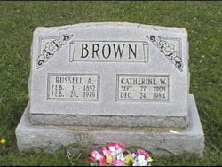
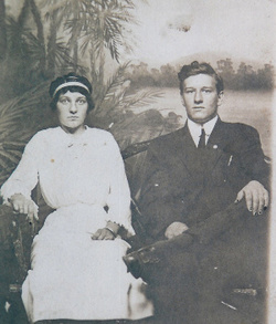
| Description | : | Upton Brown, born at Lantz, Frederick County, MD. Farmed at Bulltail, near Lantz, at the northwestern corner of Hauver's district, Frederick County. MD. He was diabetic and died of gangrene at Johns Hopkins University Hospital, Baltimore, MD. Certificate of Death, Health Department-City Of Baltimore, Number D3923, filed April 2,1917. My great grandfather was stern man. Son Charles W. Brown, my grandfather told his children the story of how he and his brother Russell would pick up stones in a snow covered field on the family farm till their fingers were bloody. The blood from their fingers staining the snow.... Read More |
frequently asked questions (FAQ):
-
Where is Upton B. Brown's memorial?
Upton B. Brown's memorial is located at: Elliston Cemetery, Elliston, Powell County, USA.
-
When did Upton B. Brown death?
Upton B. Brown death on 31 Mar 1917 in Baltimore, Baltimore City, Maryland, USA
-
Where are the coordinates of the Upton B. Brown's memorial?
Latitude: 46.5693090
Longitude: -112.4406270
Family Members:
Parent
Spouse
Siblings

Children


Flowers:


Nearby Cemetories:
1. Elliston Cemetery
Elliston, Powell County, USA
Coordinate: 46.5693090, -112.4406270
2. Old Elliston Cemetery
Elliston, Powell County, USA
Coordinate: 46.5610000, -112.3983000
3. Avon Cemetery
Avon, Powell County, USA
Coordinate: 46.6111580, -112.6049040
4. Blackfoot City Cemetery
Avon, Powell County, USA
Coordinate: 46.6800000, -112.5520000
5. Marysville Cemetery
Lewis and Clark County, USA
Coordinate: 46.7566986, -112.2902985
6. Fort William Henry Harrison Cemetery
Helena, Lewis and Clark County, USA
Coordinate: 46.6227000, -112.1103000
7. Montana State Veterans Cemetery
Helena, Lewis and Clark County, USA
Coordinate: 46.6151886, -112.0993042
8. Montana Medal of Honor Grove
Helena, Lewis and Clark County, USA
Coordinate: 46.6227300, -112.0956300
9. Silver City Cemetery
Silver City, Lewis and Clark County, USA
Coordinate: 46.7360992, -112.1800003
10. John Montgomery Gravesite
Unionville, Lewis and Clark County, USA
Coordinate: 46.5170000, -112.0845000
11. Calvary Cemetery
Lewis and Clark County, USA
Coordinate: 46.5997009, -112.0714035
12. Home of Peace Cemetery
Helena, Lewis and Clark County, USA
Coordinate: 46.6152992, -112.0500031
13. Silver Creek Road Cemetery
Lewis and Clark County, USA
Coordinate: 46.6994500, -112.0916000
14. Saint Peters Episcopal Cathedral Columbarium
Helena, Lewis and Clark County, USA
Coordinate: 46.5925598, -112.0400925
15. Benton Avenue Cemetery
Helena, Lewis and Clark County, USA
Coordinate: 46.6045265, -112.0415497
16. Hillcrest Cemetery
Deer Lodge, Powell County, USA
Coordinate: 46.3958015, -112.7556000
17. City Cemetery (Defunct)
Helena, Lewis and Clark County, USA
Coordinate: 46.5896660, -112.0360010
18. Montana State Prison Cemetery
Deer Lodge, Powell County, USA
Coordinate: 46.3959999, -112.7590027
19. Cathedral of the Sacred Hearts of Jesus and Mary
Helena, Lewis and Clark County, USA
Coordinate: 46.5902550, -112.0339480
20. Lewis and Clark County Poor Farm Cemetery
Helena, Lewis and Clark County, USA
Coordinate: 46.6235460, -112.0383316
21. Old Catholic Cemetery
Helena, Lewis and Clark County, USA
Coordinate: 46.5779120, -112.0183220
22. Forestvale Cemetery
Helena, Lewis and Clark County, USA
Coordinate: 46.6563988, -112.0361023
23. IOOF Cemetery
Helena, Lewis and Clark County, USA
Coordinate: 46.6535873, -112.0311966
24. Lewis and Clark County Cemetery
Helena, Lewis and Clark County, USA
Coordinate: 46.6558870, -112.0319440