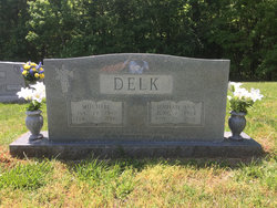
Van Mitchell Delk
| Birth | : | 29 Jan 1917 Randolph County, North Carolina, USA |
| Death | : | 20 Feb 2000 High Point, Guilford County, North Carolina, USA |
| Burial | : | Piney Grove Methodist Church, Jackson Creek, Randolph County, USA |
| Coordinate | : | 35.6920000, -80.0340000 |
| Description | : | Van Mitchell Delk Archdale – Van Mitchell Delk, 83, of 323 Blair Drive, formerly of 675 Dogwood Circle, High Point, died Feb. 20, 2000, at High Point Regional Hospital. He was born Jan. 29, 1917, in Randolph County a son of John (should read James) Franklin and Essie Skeen Delk, who preceded him in death. He was retired owner of J&D Commercial Refrigeration. He served in the U.S. Army in the occupation forces in Japan during World War II. He was a member of Piney Grove United Methodist Church and a member of the Thomasville Assembly of God. He was... Read More |
frequently asked questions (FAQ):
-
Where is Van Mitchell Delk's memorial?
Van Mitchell Delk's memorial is located at: Piney Grove Methodist Church, Jackson Creek, Randolph County, USA.
-
When did Van Mitchell Delk death?
Van Mitchell Delk death on 20 Feb 2000 in High Point, Guilford County, North Carolina, USA
-
Where are the coordinates of the Van Mitchell Delk's memorial?
Latitude: 35.6920000
Longitude: -80.0340000
Family Members:
Parent
Spouse
Siblings
Children
Flowers:
Nearby Cemetories:
1. Piney Grove Methodist Church
Jackson Creek, Randolph County, USA
Coordinate: 35.6920000, -80.0340000
2. Mount Tabor Methodist Church Cemetery
Jackson Creek, Randolph County, USA
Coordinate: 35.6954230, -80.0124970
3. North Bend Cemetery
Jackson Creek, Randolph County, USA
Coordinate: 35.6730000, -80.0213000
4. Walters Grove Baptist Church Cemetery
Lexington, Davidson County, USA
Coordinate: 35.6988260, -80.0673240
5. Pierces Chapel Primitive Baptist Church Cemetery
Trinity, Randolph County, USA
Coordinate: 35.7141953, -80.0097046
6. Canaan United Methodist Church Cemetery
Denton, Davidson County, USA
Coordinate: 35.6690000, -80.0630000
7. Pleasant Union Community Church Cemetery
Randolph County, USA
Coordinate: 35.6922910, -79.9885640
8. Hoover Cemetery
Jackson Creek, Randolph County, USA
Coordinate: 35.6836200, -79.9812800
9. Hoovers Grove Wesleyan Church Cemetery
Randolph County, USA
Coordinate: 35.6829870, -79.9796830
10. Garner Family Cemetery
Denton, Davidson County, USA
Coordinate: 35.6575800, -80.0717900
11. Pleasant Grove Methodist Church
Asheboro, Randolph County, USA
Coordinate: 35.7344704, -80.0565033
12. Cedar Springs Cemetery
Cid, Davidson County, USA
Coordinate: 35.6803017, -80.0960999
13. Old Fashion Baptist Church Cemetery
Randolph County, USA
Coordinate: 35.6408790, -80.0238300
14. Snider Cemetery
Denton, Davidson County, USA
Coordinate: 35.6614000, -80.0879500
15. Fairview United Methodist Church
Denton, Davidson County, USA
Coordinate: 35.6870000, -80.1000000
16. Stout Cemetery
Denton, Davidson County, USA
Coordinate: 35.6439100, -80.0689600
17. Tabernacle United Methodist Church Cemetery
Randolph County, USA
Coordinate: 35.7485500, -80.0042000
18. Farmer United Methodist Church Cemetery
Farmer, Randolph County, USA
Coordinate: 35.6500330, -79.9767170
19. Farmer Baptist Church Cemetery
Farmer, Randolph County, USA
Coordinate: 35.6527300, -79.9716300
20. Salem Fellowship Church Cemetery
Denton, Davidson County, USA
Coordinate: 35.6268190, -80.0306790
21. New Jerusalem Lutheran Church Cemetery
Davidson County, USA
Coordinate: 35.7318100, -80.0990860
22. Salem United Methodist Church Cemetery
Martha, Randolph County, USA
Coordinate: 35.6255170, -80.0315170
23. Westfield Baptist Church Cemetery
Trinity, Randolph County, USA
Coordinate: 35.7630539, -80.0314102
24. Mount Ebal United Methodist Church Cemetery
Denton, Davidson County, USA
Coordinate: 35.6261120, -80.0673550


