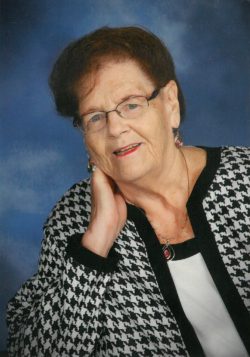
Vergean Mae Freitag Schmidt
| Birth | : | 18 Apr 1934 Elkader, Clayton County, Iowa, USA |
| Death | : | 21 Apr 2017 Elkader, Clayton County, Iowa, USA |
| Burial | : | Farmersburg-Wagner Cemetery, Farmersburg, Clayton County, USA |
| Coordinate | : | 42.9481010, -91.3700027 |
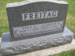
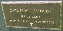
| Description | : | Vergean Mae Schmidt 83 of Farmersburg, Iowa died Friday April 21, 2017 at the Elkader Care Center, Elkader, Iowa. Vergean M. Freitag was born April 18, 1934 in Elkader. She was the daughter of Glendor and Vera (Breitsprecher) Freitag. She received her education in Elkader, graduating from Elkader High School with the class of 1951. On September 8, 1953, she was united in marriage to Carl Schmidt at Peace United Church of Christ in Elkader. Vergean worked as a telephone operator in Elkader, was the school cook at the Farmersburg School for twelve years and... Read More |
frequently asked questions (FAQ):
-
Where is Vergean Mae Freitag Schmidt's memorial?
Vergean Mae Freitag Schmidt's memorial is located at: Farmersburg-Wagner Cemetery, Farmersburg, Clayton County, USA.
-
When did Vergean Mae Freitag Schmidt death?
Vergean Mae Freitag Schmidt death on 21 Apr 2017 in Elkader, Clayton County, Iowa, USA
-
Where are the coordinates of the Vergean Mae Freitag Schmidt's memorial?
Latitude: 42.9481010
Longitude: -91.3700027
Family Members:
Parent
Spouse
Children
Flowers:
Nearby Cemetories:
1. Farmersburg-Wagner Cemetery
Farmersburg, Clayton County, USA
Coordinate: 42.9481010, -91.3700027
2. Bismark Cemetery
Farmersburg, Clayton County, USA
Coordinate: 42.9790000, -91.3500000
3. Norway Lutheran Church Cemetery
Saint Olaf, Clayton County, USA
Coordinate: 42.9352798, -91.4302826
4. Gooding Cemetery
Wagner Township, Clayton County, USA
Coordinate: 42.9869490, -91.4191570
5. County Home Cemetery
Clayton Center, Clayton County, USA
Coordinate: 42.8916702, -91.3499985
6. National Cemetery
National, Clayton County, USA
Coordinate: 42.9536018, -91.2902985
7. Wagner Township Cemetery
Saint Olaf, Clayton County, USA
Coordinate: 42.9519386, -91.4513931
8. Patterson Pioneer Cemetery
Saint Olaf, Clayton County, USA
Coordinate: 42.9216000, -91.4489000
9. Giard Cemetery
Farmersburg, Clayton County, USA
Coordinate: 42.9933014, -91.3080978
10. Colony Catholic Cemetery (Defunct)
Read Township, Clayton County, USA
Coordinate: 42.8830000, -91.3580000
11. Weymouth Cemetery
Saint Olaf, Clayton County, USA
Coordinate: 42.9278799, -91.4583559
12. Zion Lutheran Cemetery
Clayton Center, Clayton County, USA
Coordinate: 42.8841705, -91.3249969
13. Clayton Center Cemetery
Clayton Center, Clayton County, USA
Coordinate: 42.8841705, -91.3225021
14. Pioneer Cemetery
Monona, Clayton County, USA
Coordinate: 43.0149994, -91.4274979
15. Clark Family Cemetery
Beulah, Clayton County, USA
Coordinate: 42.9166505, -91.4751415
16. Eno Cemetery
Wagner Township, Clayton County, USA
Coordinate: 42.9930992, -91.4693985
17. Railroad Employee Cemetery
Giard, Clayton County, USA
Coordinate: 43.0305395, -91.3140229
18. Elkader Cemetery
Elkader, Clayton County, USA
Coordinate: 42.8541718, -91.4000015
19. Saint Paul Lutheran Cemetery
Monona, Clayton County, USA
Coordinate: 43.0494385, -91.3847198
20. Saint Josephs Cemetery
Elkader, Clayton County, USA
Coordinate: 42.8488998, -91.4021988
21. Saint Patricks Cemetery
Monona, Clayton County, USA
Coordinate: 43.0496000, -91.3850000
22. Monona Cemetery
Monona, Clayton County, USA
Coordinate: 43.0531006, -91.3799973
23. Cook Family Cemetery
Elkader, Clayton County, USA
Coordinate: 42.9209880, -91.5091230
24. Marion Lutheran Cemetery
Gunder, Clayton County, USA
Coordinate: 42.9708290, -91.5127792

