
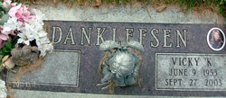

Vicky Kay Hough Danklefsen
| Birth | : | 9 Jun 1953 Miles City, Custer County, Montana, USA |
| Death | : | 27 Sep 2003 Miles City, Custer County, Montana, USA |
| Burial | : | Fairfield Friends Cemetery, Friendswood, Hendricks County, USA |
| Coordinate | : | 39.6606026, -86.3355865 |
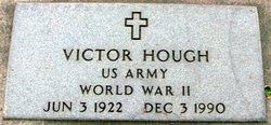
| Description | : | SOURCE: Death Certificate: '''''''''''''''''''''''''''''''''''''''''''''''''''''' Vicky Danklefsen, age 50, of Miles City passed away on Saturday, September 27, 2003 at the Holy Rosary Health Center in Miles City. Vicky was born in Miles City, Montana on June 9, 1953, the daughter of Victor "Slim" and Ilene (Oster) Hough. She attended schools and graduated from Custer County High School. Following graduation, she worked as short time for the Red Rock Motel. She then received her nurses training and began working at the Friendship Villa. Vicky married Lynn Danklefsen on September 5, 1975 in Miles City. She raised four children... Read More |
frequently asked questions (FAQ):
-
Where is Vicky Kay Hough Danklefsen's memorial?
Vicky Kay Hough Danklefsen's memorial is located at: Fairfield Friends Cemetery, Friendswood, Hendricks County, USA.
-
When did Vicky Kay Hough Danklefsen death?
Vicky Kay Hough Danklefsen death on 27 Sep 2003 in Miles City, Custer County, Montana, USA
-
Where are the coordinates of the Vicky Kay Hough Danklefsen's memorial?
Latitude: 39.6606026
Longitude: -86.3355865
Family Members:
Parent

Spouse

Siblings
Flowers:


Nearby Cemetories:
1. Fairfield Friends Cemetery
Friendswood, Hendricks County, USA
Coordinate: 39.6606026, -86.3355865
2. Lick Branch Cemetery
Guilford Township, Hendricks County, USA
Coordinate: 39.6598800, -86.3357040
3. Lick Branch Cemetery
Plainfield, Hendricks County, USA
Coordinate: 39.6598663, -86.3356476
4. Siloam Cemetery
Morgan County, USA
Coordinate: 39.6286011, -86.3236008
5. Center Friends Cemetery
Bridgeport, Marion County, USA
Coordinate: 39.6975784, -86.3258438
6. Easton Friends Cemetery
West Newton, Marion County, USA
Coordinate: 39.6539450, -86.2797060
7. White Lick Friends Cemetery
Friendswood, Hendricks County, USA
Coordinate: 39.6375313, -86.3846130
8. West Newton Cemetery
West Newton, Marion County, USA
Coordinate: 39.6502037, -86.2781982
9. Old Friends Cemetery (Defunct)
Marion County, USA
Coordinate: 39.6966270, -86.2885390
10. Ramsey Cemetery
Plainfield, Hendricks County, USA
Coordinate: 39.6386337, -86.3955002
11. Sugar Grove Cemetery
Plainfield, Hendricks County, USA
Coordinate: 39.6747665, -86.3998184
12. Lick Branch Cemetery (Defunct)
Decatur Township, Marion County, USA
Coordinate: 39.7067000, -86.3025000
13. Mooresville Cemetery
Mooresville, Morgan County, USA
Coordinate: 39.6108055, -86.3671951
14. Old Methodist Episcopal Cemetery
Mooresville, Morgan County, USA
Coordinate: 39.6141510, -86.3759079
15. McNabb Cemetery
Morgan County, USA
Coordinate: 39.6219720, -86.2825830
16. Plainfield United Methodist Church Columbarium
Plainfield, Hendricks County, USA
Coordinate: 39.7004170, -86.3881710
17. White Lick Cemetery
Mooresville, Morgan County, USA
Coordinate: 39.6210785, -86.3939285
18. Maple Hill Cemetery
Plainfield, Hendricks County, USA
Coordinate: 39.6984863, -86.3963165
19. Saint Marks Episcopal Church Columbarium
Plainfield, Hendricks County, USA
Coordinate: 39.7039980, -86.3916880
20. Indianapolis International Airport
Indianapolis, Marion County, USA
Coordinate: 39.7170600, -86.2949700
21. Carpenter Cemetery
Mooresville, Morgan County, USA
Coordinate: 39.5949040, -86.3395920
22. Mount Pleasant Baptist Cemetery
West Newton, Marion County, USA
Coordinate: 39.6702160, -86.2503010
23. Indiana Boys School Cemetery
Plainfield, Hendricks County, USA
Coordinate: 39.6967506, -86.4089127
24. Carter Evans Cemetery
Morgan County, USA
Coordinate: 39.5956670, -86.3073330