

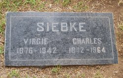
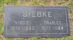
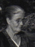
Virginia “Virgie” Owen Siebke
| Birth | : | 8 May 1876 Jobe, Oregon County, Missouri, USA |
| Death | : | 13 Dec 1942 Goleta, Santa Barbara County, California, USA |
| Burial | : | Goleta Cemetery, Goleta, Santa Barbara County, USA |
| Coordinate | : | 34.4407997, -119.7802963 |
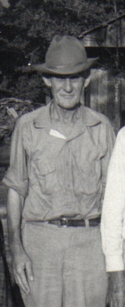
| Description | : | Virgie's father was Gideon Jackson Owen, born Murray co Ga. He died probably in Clay or Randolph, Arkansas. Virgie's mother was Lucinda Taylor of Oregon Co. Mo. Lucinda and Gideon had two daughters Virginia and Harriet then divorced in 1880. Lucinda remarried to Saul Brewer and had four additional children, before her death abt 1899. Virgie married Charles Siebke 06 Oct 1897 in Butler co. Mo. No known children. Parents of Gideon Owen were James Madison Owen/Oyen Born Sep 1849 South Carolina. Died between 1865 and 1870 Ark. Married Martha Blair 1832 Habersham, Ga. Martha born abt 1814 Ga. 1870 census shows... Read More |
frequently asked questions (FAQ):
-
Where is Virginia “Virgie” Owen Siebke's memorial?
Virginia “Virgie” Owen Siebke's memorial is located at: Goleta Cemetery, Goleta, Santa Barbara County, USA.
-
When did Virginia “Virgie” Owen Siebke death?
Virginia “Virgie” Owen Siebke death on 13 Dec 1942 in Goleta, Santa Barbara County, California, USA
-
Where are the coordinates of the Virginia “Virgie” Owen Siebke's memorial?
Latitude: 34.4407997
Longitude: -119.7802963
Family Members:
Parent
Spouse
Siblings


Nearby Cemetories:
1. Goleta Cemetery
Goleta, Santa Barbara County, USA
Coordinate: 34.4407997, -119.7802963
2. Cieneguitas Catholic Cemetery
La Patera, Santa Barbara County, USA
Coordinate: 34.4402920, -119.7744090
3. Potters Field Cemetery
Goleta, Santa Barbara County, USA
Coordinate: 34.4526310, -119.7686540
4. Christ the King Episcopal Church Memorial Garden
Santa Barbara, Santa Barbara County, USA
Coordinate: 34.4343418, -119.7998439
5. Calvary Cemetery
Santa Barbara, Santa Barbara County, USA
Coordinate: 34.4432983, -119.7466965
6. Mission Santa Barbara Cemetery
Santa Barbara, Santa Barbara County, USA
Coordinate: 34.4378800, -119.7134600
7. Presidio Cemetery
Santa Barbara, Santa Barbara County, USA
Coordinate: 34.4228790, -119.6991480
8. Santa Barbara Cemetery
Santa Barbara, Santa Barbara County, USA
Coordinate: 34.4188995, -119.6544037
9. All Saints By The Sea Episcopal Church Columbarium
Montecito, Santa Barbara County, USA
Coordinate: 34.4210500, -119.6312100
10. Montecito Cemetery
Montecito, Santa Barbara County, USA
Coordinate: 34.4363080, -119.5959850
11. Carpinteria Cemetery
Carpinteria, Santa Barbara County, USA
Coordinate: 34.4118996, -119.5385971
12. Ferrer Family Ranch Grounds
Carpinteria, Santa Barbara County, USA
Coordinate: 34.3821940, -119.4812560
13. Rancho del Cielo Cemetery
Santa Barbara, Santa Barbara County, USA
Coordinate: 34.5304780, -120.0758920
14. Capuchin Cemetery
Santa Ynez, Santa Barbara County, USA
Coordinate: 34.6442860, -120.0270440
15. Mission Santa Ines Cemetery
Solvang, Santa Barbara County, USA
Coordinate: 34.5943880, -120.1365550
16. Oak Hill Cemetery
Ballard, Santa Barbara County, USA
Coordinate: 34.6324997, -120.1106033
17. Solvang Cemetery
Solvang, Santa Barbara County, USA
Coordinate: 34.6017000, -120.1443920
18. Saint Mark's-in-the-Valley Church Mem. Garden
Los Olivos, Santa Barbara County, USA
Coordinate: 34.6662590, -120.1177210
19. Ojai United Methodist Memorial Garden
Ojai, Ventura County, USA
Coordinate: 34.4437040, -119.2665540
20. Saint Thomas Aquinas Cemetery
Ojai, Ventura County, USA
Coordinate: 34.4301250, -119.2650250
21. Nordhoff Cemetery
Ojai, Ventura County, USA
Coordinate: 34.4446600, -119.2604400
22. Mission San Buenaventura Cemetery
Ventura, Ventura County, USA
Coordinate: 34.2811890, -119.2982090
23. Ojai Presbyterian Church Columbarium
Ojai, Ventura County, USA
Coordinate: 34.4494250, -119.2530420
24. Saint Andrews Episcopal Church Columbarium
Ojai, Ventura County, USA
Coordinate: 34.4454300, -119.2513700