
| Birth | : | 14 Jul 1927 Clyde, Cloud County, Kansas, USA |
| Death | : | 11 Jun 1979 Kansas City, Wyandotte County, Kansas, USA |
| Burial | : | Mount Calvary Cemetery, Clyde, Cloud County, USA |
| Coordinate | : | 39.5917015, -97.4143982 |
| Plot | : | Site J/7 |
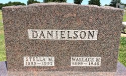
| Inscription | : | Married Nov. 5, 1949 Parents of Michael, Gary, Julie, Jon and Jeffrey |
| Description | : | Salina Journal June 13, 1979 WALLACE W. DANIELSON CLYDE — The funeral for Wallace Whitney Danielson, 51, Clyde, will be at 10 a.m. Thursday at St. John the Baptist Catholic Church, Clyde, Father Henry J. Kieffer officiating. Burial will be in Mt. Calvary Cemetery, Clyde. Mr. Danielson died Monday at the University of Kansas Medical Center. He was born July 14, 1927, at Clyde and was a lifelong resident. He was a farmer, a member of the Catholic church, a World War II veteran and a member of Veterans of Foreign Wars, No. 7515 at Clyde. Surviving are his wife, Maxine, of the... Read More |
frequently asked questions (FAQ):
-
Where is Wallace Whitney Danielson's memorial?
Wallace Whitney Danielson's memorial is located at: Mount Calvary Cemetery, Clyde, Cloud County, USA.
-
When did Wallace Whitney Danielson death?
Wallace Whitney Danielson death on 11 Jun 1979 in Kansas City, Wyandotte County, Kansas, USA
-
Where are the coordinates of the Wallace Whitney Danielson's memorial?
Latitude: 39.5917015
Longitude: -97.4143982
Family Members:
Parent

Spouse

Flowers:


Nearby Cemetories:
1. Mount Calvary Cemetery
Clyde, Cloud County, USA
Coordinate: 39.5917015, -97.4143982
2. Mount Hope Cemetery
Clyde, Cloud County, USA
Coordinate: 39.5969009, -97.4116974
3. Cedar Grove Cemetery
Clyde, Cloud County, USA
Coordinate: 39.5494003, -97.4056015
4. Pleasant View Cemetery
Ames, Cloud County, USA
Coordinate: 39.5346985, -97.4431000
5. Walnut Grove Cemetery
Cloud County, USA
Coordinate: 39.5699997, -97.4993973
6. Saint Joseph Cemetery
Saint Joseph, Cloud County, USA
Coordinate: 39.5074941, -97.4022328
7. Agenda Cemetery
Agenda, Republic County, USA
Coordinate: 39.6761017, -97.4336014
8. Green Mound Cemetery
Rice, Cloud County, USA
Coordinate: 39.5248450, -97.5081630
9. Hollis Cemetery
Cloud County, USA
Coordinate: 39.6383018, -97.5361023
10. Beck Family Cemetery
Agenda, Republic County, USA
Coordinate: 39.6818000, -97.4863000
11. Rice Cemetery
Rice, Cloud County, USA
Coordinate: 39.5614014, -97.5552979
12. Nelson Cemetery
Rice, Cloud County, USA
Coordinate: 39.5257988, -97.5410995
13. Riverdale Cemetery
Clay County, USA
Coordinate: 39.5106010, -97.2930984
14. Saint Peters Cemetery
Aurora, Cloud County, USA
Coordinate: 39.4763985, -97.5180969
15. Princeville Cemetery
Aurora, Cloud County, USA
Coordinate: 39.4672012, -97.5010986
16. Iwacura Cemetery
Morganville, Clay County, USA
Coordinate: 39.4550000, -97.3510000
17. Union Cemetery
Wayne, Republic County, USA
Coordinate: 39.6977997, -97.5457993
18. Willoughby Cemetery
Agenda, Republic County, USA
Coordinate: 39.7402992, -97.4244003
19. French Presbyterian Church Cemetery
Cloud County, USA
Coordinate: 39.4395200, -97.4148290
20. Gotland Cemetery
Sibley Township, Cloud County, USA
Coordinate: 39.6091995, -97.6125031
21. Sherman Cemetery
Morganville, Clay County, USA
Coordinate: 39.5316300, -97.2243700
22. Zion Cemetery
Agenda, Republic County, USA
Coordinate: 39.6749992, -97.5939026
23. Rose Hill Cemetery
Wayne, Republic County, USA
Coordinate: 39.7111015, -97.5661011
24. Minersville Cemetery
Talmo, Republic County, USA
Coordinate: 39.6568330, -97.6229250