
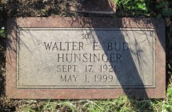
Walter E. “Bud” Hunsinger
| Birth | : | 17 Sep 1921 |
| Death | : | 1 May 1999 Lawrence, Douglas County, Kansas, USA |
| Burial | : | Oak Hill Cemetery, Lawrence, Douglas County, USA |
| Coordinate | : | 38.9589005, -95.2118988 |
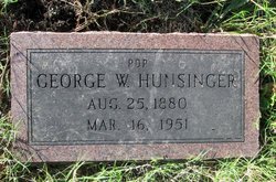
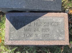
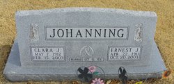
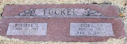
| Description | : | LAWRENCE -- Walter E. "Bud" Hunsinger, 77, Lawrence, died Saturday, May 1, 1999, at his home. Mr. Hunsinger was a farmer and stockman. He was born Sept. 17, 1921, in Douglas County, the son of George W. Hunsinger and Mary J. Seele. He was lifelong resident of the Lawrence area. Mr. Hunsinger was a member of the Douglas County Farm Bureau and the Famers Coop in Lawrence and Ottawa, and the Douglas County Democratic Party. Survivors include four sisters, Elsie Hunsinger, at home, Clara Johanning, Baldwin City, Dora Tuckel, Lawrence, and Ann Radcliff, Coffeyville. Services will be at 2 p.m. Tuesday at... Read More |
frequently asked questions (FAQ):
-
Where is Walter E. “Bud” Hunsinger's memorial?
Walter E. “Bud” Hunsinger's memorial is located at: Oak Hill Cemetery, Lawrence, Douglas County, USA.
-
When did Walter E. “Bud” Hunsinger death?
Walter E. “Bud” Hunsinger death on 1 May 1999 in Lawrence, Douglas County, Kansas, USA
-
Where are the coordinates of the Walter E. “Bud” Hunsinger's memorial?
Latitude: 38.9589005
Longitude: -95.2118988
Family Members:
Parent
Siblings
Flowers:


Nearby Cemetories:
1. Oak Hill Cemetery
Lawrence, Douglas County, USA
Coordinate: 38.9589005, -95.2118988
2. Mount Calvary Catholic Cemetery
Lawrence, Douglas County, USA
Coordinate: 38.9580002, -95.2139969
3. Memorial Park Cemetery
Lawrence, Douglas County, USA
Coordinate: 38.9552994, -95.2153015
4. Trinity Episcopal Church Columbarium
Lawrence, Douglas County, USA
Coordinate: 38.9653893, -95.2373886
5. Saint Johns Catholic Cemetery
Douglas County, USA
Coordinate: 38.9437900, -95.1919600
6. Dyche Hall Natural History Museum
Lawrence, Douglas County, USA
Coordinate: 38.9584800, -95.2434800
7. Franklin Cemetery
Douglas County, USA
Coordinate: 38.9437523, -95.1869431
8. Haskell Cemetery
Lawrence, Douglas County, USA
Coordinate: 38.9353790, -95.2284241
9. Pioneer Cemetery
Lawrence, Douglas County, USA
Coordinate: 38.9528008, -95.2611008
10. First Presbyterian Church Memorial Garden
Lawrence, Douglas County, USA
Coordinate: 38.9414900, -95.2641600
11. Maple Grove Cemetery
Lawrence, Douglas County, USA
Coordinate: 39.0018997, -95.2316971
12. County Poor Farm Cemetery
Douglas County, USA
Coordinate: 38.9119400, -95.2214600
13. Adams Cemetery
Douglas County, USA
Coordinate: 38.9955400, -95.2509100
14. Kennedy Cemetery
Douglas County, USA
Coordinate: 38.9112900, -95.2269200
15. Davis Cemetery
Lawrence, Douglas County, USA
Coordinate: 38.9722500, -95.2831100
16. Blue Mound Cemetery
Lawrence, Douglas County, USA
Coordinate: 38.9046600, -95.1865400
17. Marshall Cemetery
Douglas County, USA
Coordinate: 38.9040800, -95.2446700
18. Dutton Cemetery
Douglas County, USA
Coordinate: 38.8989800, -95.2790600
19. Luckan Family Cemetery
Fall Leaf, Leavenworth County, USA
Coordinate: 38.9808500, -95.1128000
20. Cemetery Beni Israel
Eudora, Douglas County, USA
Coordinate: 38.9280128, -95.1122208
21. Southwest City Cemetery
Eudora, Douglas County, USA
Coordinate: 38.9334800, -95.1070300
22. Lyon Family Cemetery
Lawrence, Douglas County, USA
Coordinate: 38.9877440, -95.3166530
23. Corpus Christi Catholic Church Columbarium
Lawrence, Douglas County, USA
Coordinate: 38.9572250, -95.3238450
24. Richland Cemetery
Lawrence, Douglas County, USA
Coordinate: 38.8768997, -95.2630997