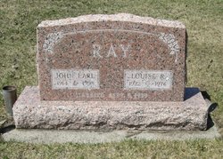
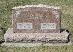
| Birth | : | 13 Feb 1941 Oak Creek, Routt County, Colorado, USA |
| Death | : | 22 Dec 2010 |
| Burial | : | Greensburg Cemetery, Green, Summit County, USA |
| Coordinate | : | 40.9305992, -81.4792023 |
| Description | : | Wayne Earl Ray, 69, passed away December 22, 2010 at his home in Clifton, CO. Wayne was born February 13, 1941, to Earl and Louise (Laman) Ray in Oak Creek, Colorado. He grew up in Toponas, CO, where his parents owned a sawmill. Wayne graduated from Yampa Union High School in Yampa, CO in 1958. While still in school he worked summers in the lettuce and spinach fields and at his parents' sawmill. Following graduation, he worked at the sawmill until 1965, when he joined the United States Air Force. Wayne served his country in Vietnam... Read More |
frequently asked questions (FAQ):
-
Where is Wayne Earl Ray's memorial?
Wayne Earl Ray's memorial is located at: Greensburg Cemetery, Green, Summit County, USA.
-
When did Wayne Earl Ray death?
Wayne Earl Ray death on 22 Dec 2010 in
-
Where are the coordinates of the Wayne Earl Ray's memorial?
Latitude: 40.9305992
Longitude: -81.4792023
Family Members:
Parent
Flowers:
Nearby Cemetories:
1. Greensburg Cemetery
Green, Summit County, USA
Coordinate: 40.9305992, -81.4792023
2. Klinefelter Cemetery
Green, Summit County, USA
Coordinate: 40.9383011, -81.4953995
3. Jonathan Grable Burying Ground
Green, Summit County, USA
Coordinate: 40.9126010, -81.4691160
4. Saint Paul Cemetery
McDonaldsville, Stark County, USA
Coordinate: 40.8914950, -81.4785950
5. East Liberty Cemetery
Green, Summit County, USA
Coordinate: 40.9743004, -81.4962997
6. Sunset Hills Memory Gardens
North Canton, Stark County, USA
Coordinate: 40.8954460, -81.4375730
7. Pleasant Valley Cemetery
North Canton, Stark County, USA
Coordinate: 40.9061990, -81.4218240
8. North Canton Cemetery
North Canton, Stark County, USA
Coordinate: 40.8969002, -81.4206009
9. Greentown Cemetery
Greentown, Stark County, USA
Coordinate: 40.9295000, -81.3970600
10. Mount Pleasant Cemetery
Canton, Stark County, USA
Coordinate: 40.9078400, -81.4020600
11. Mudbrook Cemetery
Massillon, Stark County, USA
Coordinate: 40.8727989, -81.5141983
12. Manchester Cemetery
New Franklin, Summit County, USA
Coordinate: 40.9352989, -81.5708008
13. Greenlawn Cemetery
Uniontown, Stark County, USA
Coordinate: 40.9782982, -81.4103012
14. Old Lutheran Cemetery
Uniontown, Stark County, USA
Coordinate: 40.9772290, -81.4081710
15. Faith United Methodist Church Columbarium
North Canton, Stark County, USA
Coordinate: 40.8843520, -81.4076290
16. Woods Cemetery
Uniontown, Stark County, USA
Coordinate: 40.9757996, -81.4008026
17. Church of the Lakes Church Columbarium
Canton, Stark County, USA
Coordinate: 40.8558440, -81.4605370
18. Pleasant Valley Cemetery
Akron, Summit County, USA
Coordinate: 41.0065002, -81.4931030
19. Milheim Cemetery
Millheim, Summit County, USA
Coordinate: 41.0018005, -81.4345016
20. Saint Pauls Cemetery
North Canton, Stark County, USA
Coordinate: 40.8736000, -81.4028015
21. Sunset Hills Burial Park
Canton, Stark County, USA
Coordinate: 40.8537400, -81.4408600
22. Slovak Evangelical Cemetery
Krumroy, Summit County, USA
Coordinate: 41.0131989, -81.4675980
23. Kyser Cemetery
Barberton, Summit County, USA
Coordinate: 40.9775696, -81.5713272
24. Lockwood Cemetery
Akron, Summit County, USA
Coordinate: 41.0003014, -81.5582962


