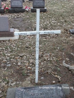
Wayne R. “Mugzie” Myrstol
| Birth | : | 10 Oct 1951 Livingston, Park County, Montana, USA |
| Death | : | 15 Jun 2001 Elliston Township, Tripp County, South Dakota, USA |
| Burial | : | Mountain View Cemetery, Big Timber, Sweet Grass County, USA |
| Coordinate | : | 45.8243660, -109.9660960 |
| Plot | : | Section 6 Block 23A Lot 1 Grave 5 |
| Description | : | Big Timber Pioneer, 22 June 2001 Mayne (Mugzie) R. Myrstol died Friday, June 15, 2001, of a heart attack in Elliston. Wayne was born October 10, 1951, in Livingston to Elmer and Evelyn Myrstol. He attended school at the Duck Creek country school, Big Timber Grade School, and graduated from Sweet Grass County High School in 1970. Wayne worked for Burlington Northern and Montana Rail Link for over 25 years. He was disabled at the time of his death due to a back injury incurred while working for the railroad. Wayne was known by most of his friends as Mugzie. |
frequently asked questions (FAQ):
-
Where is Wayne R. “Mugzie” Myrstol's memorial?
Wayne R. “Mugzie” Myrstol's memorial is located at: Mountain View Cemetery, Big Timber, Sweet Grass County, USA.
-
When did Wayne R. “Mugzie” Myrstol death?
Wayne R. “Mugzie” Myrstol death on 15 Jun 2001 in Elliston Township, Tripp County, South Dakota, USA
-
Where are the coordinates of the Wayne R. “Mugzie” Myrstol's memorial?
Latitude: 45.8243660
Longitude: -109.9660960
Family Members:
Parent
Siblings
Flowers:
Nearby Cemetories:
1. Mountain View Cemetery
Big Timber, Sweet Grass County, USA
Coordinate: 45.8243660, -109.9660960
2. Thomas Massacre Gravesite
Greycliff, Sweet Grass County, USA
Coordinate: 45.7351500, -109.7144000
3. Hunters Hot Springs Cemetery
Hunters Hot Springs, Park County, USA
Coordinate: 45.7551000, -110.2570000
4. Kent Cemetery
Sweet Grass County, USA
Coordinate: 45.7308006, -109.6722031
5. Melville Lutheran Cemetery
Melville, Sweet Grass County, USA
Coordinate: 46.1074982, -110.0397034
6. Reed Point Cemetery
Sweet Grass County, USA
Coordinate: 45.7033005, -109.5622025
7. Bruffey Cemetery
Livingston, Park County, USA
Coordinate: 45.6206200, -110.3741910
8. Rock Creek Cemetery
Park County, USA
Coordinate: 45.8944016, -110.4993973
9. Park County Poor Farm Cemetery
Livingston, Park County, USA
Coordinate: 45.6860470, -110.4924250
10. Calvary Cemetery
Livingston, Park County, USA
Coordinate: 45.6913986, -110.5282974
11. Nye Cemetery
Nye, Stillwater County, USA
Coordinate: 45.4272003, -109.7630997
12. Hopkins Cemetery
Sweet Grass County, USA
Coordinate: 46.2113991, -110.2205963
13. Saint Margarets Cemetery
Clyde Park, Park County, USA
Coordinate: 45.9000810, -110.6005990
14. Clyde Park Cemetery
Clyde Park, Park County, USA
Coordinate: 45.9000850, -110.6013180
15. Mountain View Cemetery
Livingston, Park County, USA
Coordinate: 45.6617012, -110.5883026
16. Park View Memorial Gardens
Livingston, Park County, USA
Coordinate: 45.5739288, -110.5668182
17. Rosebud Cemetery
Stillwater County, USA
Coordinate: 45.4807014, -109.4459000
18. Wilsall Cemetery
Wilsall, Park County, USA
Coordinate: 45.9824982, -110.6549988
19. Holland Settlement Cemetery
Stillwater County, USA
Coordinate: 45.8280983, -109.2331009
20. Rapelje Cemetery
Stillwater County, USA
Coordinate: 45.9552994, -109.2544022
21. Mountain View Cemetery
Columbus, Stillwater County, USA
Coordinate: 45.6417007, -109.2727966
22. Strickland Cemetery
Livingston, Park County, USA
Coordinate: 45.5435982, -110.6168976
23. Cokedale Cemetery
Livingston, Park County, USA
Coordinate: 45.6402140, -110.7229940
24. Shorthill Cemetery
Park County, USA
Coordinate: 45.4558500, -110.5771600


