
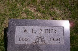
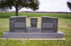
Wilborn Erwin Pitner
| Birth | : | 17 Jun 1882 Dahlonega, Lumpkin County, Georgia, USA |
| Death | : | 7 Nov 1940 Glasco, Cloud County, Kansas, USA |
| Burial | : | Saint Marys Catholic Cemetery, Glasco, Cloud County, USA |
| Coordinate | : | 39.3574000, -97.8245000 |
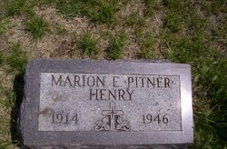
| Description | : | Nov. 14, 1940 Wilburn Pitner Dead Wilburn E. Pitner, well-known farmer of north of Delphos, passed away at his home last Thursday morning after an illness of eighteen months. Surviving are his widow, and three children, Mrs. Roy Lavy, Robert Pitner, and Miss Marian Pitner. Funeral services were held Saturday at the St. Mary's Catholic Church in Glasco. In the North of Town columnm: The funeral of W. E. Piner was held at the Catholic Church Saturday morning. Mr. Piner had been in poor health for some time and was at the Norton Sanitarium for several months. When his life was despaired of, he... Read More |
frequently asked questions (FAQ):
-
Where is Wilborn Erwin Pitner's memorial?
Wilborn Erwin Pitner's memorial is located at: Saint Marys Catholic Cemetery, Glasco, Cloud County, USA.
-
When did Wilborn Erwin Pitner death?
Wilborn Erwin Pitner death on 7 Nov 1940 in Glasco, Cloud County, Kansas, USA
-
Where are the coordinates of the Wilborn Erwin Pitner's memorial?
Latitude: 39.3574000
Longitude: -97.8245000
Family Members:
Parent

Spouse
Siblings
Children
Flowers:


Nearby Cemetories:
1. Saint Marys Catholic Cemetery
Glasco, Cloud County, USA
Coordinate: 39.3574000, -97.8245000
2. Glasco Cemetery
Glasco, Cloud County, USA
Coordinate: 39.3574000, -97.8265000
3. Bethel Cemetery
Meredith Township, Cloud County, USA
Coordinate: 39.3506000, -97.7029000
4. Simpson Cemetery
Simpson, Mitchell County, USA
Coordinate: 39.3633003, -97.9471970
5. Delphos Cemetery
Delphos, Ottawa County, USA
Coordinate: 39.2778015, -97.7416992
6. Saint Paul Cemetery
Delphos, Ottawa County, USA
Coordinate: 39.2677994, -97.7518997
7. Morrison Cemetery
Center Township, Cloud County, USA
Coordinate: 39.4817009, -97.7975006
8. Asherville Cemetery
Asherville, Mitchell County, USA
Coordinate: 39.4205000, -97.9672900
9. Summit Cemetery
Jamestown, Cloud County, USA
Coordinate: 39.4813200, -97.8628800
10. Hall Cemetery
Cloud County, USA
Coordinate: 39.4455986, -97.7033005
11. Green Mound Cemetery
Asherville, Mitchell County, USA
Coordinate: 39.3203011, -97.9858017
12. Coursen Grove Cemetery
Simpson, Mitchell County, USA
Coordinate: 39.3060989, -97.9792023
13. Saint Peters Cemetery
Miltonvale, Cloud County, USA
Coordinate: 39.3652350, -97.6483570
14. Bell-Bogardus Cemetery
Asherville, Mitchell County, USA
Coordinate: 39.4242410, -97.9919970
15. Bohemian National Cemetery
Ada, Ottawa County, USA
Coordinate: 39.2193870, -97.9054030
16. Wilcox Cemetery
Cloud County, USA
Coordinate: 39.4925003, -97.7313995
17. West Asher Cemetery
Scottsville, Mitchell County, USA
Coordinate: 39.4815000, -97.9661600
18. Baldwin Cemetery
Ottawa County, USA
Coordinate: 39.2061005, -97.9111023
19. Kindel Cemetery
Center Township, Cloud County, USA
Coordinate: 39.4519005, -97.6464005
20. Smith Cemetery
Asherville, Mitchell County, USA
Coordinate: 39.4516690, -98.0098850
21. Enterprise Cemetery
Cloud County, USA
Coordinate: 39.4230995, -97.6106033
22. McBride Cemetery
Beloit, Mitchell County, USA
Coordinate: 39.4808006, -97.9907990
23. Shiloh Cemetery
Beloit, Mitchell County, USA
Coordinate: 39.3574982, -98.0594025
24. Summit Cemetery #3
Macyville, Cloud County, USA
Coordinate: 39.5258330, -97.9194440