
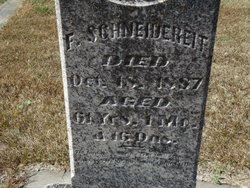
| Birth | : | Dec 1823 Germany |
| Death | : | unknown Loup City, Sherman County, Nebraska, USA |
| Burial | : | Evergreen Cemetery, Loup City, Sherman County, USA |
| Coordinate | : | 41.2997017, -98.9852982 |
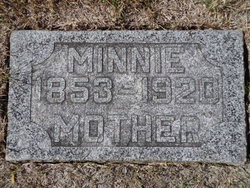
| Description | : | UNMARKED GRAVE - presumed burial location Died 1910 or after She is living with her daughter, here, in 1910 at age 86. Both her children died and were buried here. |
frequently asked questions (FAQ):
-
Where is Wilhelmina “Mina” Calinsco Schneidereit's memorial?
Wilhelmina “Mina” Calinsco Schneidereit's memorial is located at: Evergreen Cemetery, Loup City, Sherman County, USA.
-
When did Wilhelmina “Mina” Calinsco Schneidereit death?
Wilhelmina “Mina” Calinsco Schneidereit death on unknown in Loup City, Sherman County, Nebraska, USA
-
Where are the coordinates of the Wilhelmina “Mina” Calinsco Schneidereit's memorial?
Latitude: 41.2997017
Longitude: -98.9852982
Family Members:
Spouse
Children

Flowers:


Nearby Cemetories:
1. Evergreen Cemetery
Loup City, Sherman County, USA
Coordinate: 41.2997017, -98.9852982
2. Saint Josaphats Cemetery
Loup City, Sherman County, USA
Coordinate: 41.3022003, -98.9847031
3. Sunny Slope Cemetery
Loup City, Sherman County, USA
Coordinate: 41.2906000, -99.0267000
4. Cleoria Cemetery
Loup City, Sherman County, USA
Coordinate: 41.2779000, -99.0893500
5. Balsora Cemetery
Sherman County, USA
Coordinate: 41.3782997, -99.0975037
6. Austin Cemetery
Rockville, Sherman County, USA
Coordinate: 41.1880989, -98.8981018
7. Verdurette Cemetery
Sherman County, USA
Coordinate: 41.1697006, -98.9757996
8. Davis Creek Cemetery
Valley County, USA
Coordinate: 41.4219017, -98.9052963
9. Saint Francis Cemetery
Ashton, Sherman County, USA
Coordinate: 41.2438000, -98.7994000
10. Lone Elm Cemetery
Loup City, Sherman County, USA
Coordinate: 41.2921982, -99.1864014
11. Immanuel Lutheran Cemetery
Ashton, Sherman County, USA
Coordinate: 41.2140000, -98.8142000
12. Gray Cemetery
Sherman County, USA
Coordinate: 41.2099991, -99.1567001
13. Arcadia Cemetery
Arcadia, Valley County, USA
Coordinate: 41.4237000, -99.1167000
14. Pleasant Hill Friends Cemetery
Valley County, USA
Coordinate: 41.4230800, -98.8377700
15. Dunkard Cemetery
Arcadia, Valley County, USA
Coordinate: 41.4522000, -99.0769000
16. Union Cemetery
Ashton, Sherman County, USA
Coordinate: 41.2214012, -98.7855988
17. Litchfield Cemetery
Litchfield, Sherman County, USA
Coordinate: 41.1543999, -99.1283035
18. Mount Carmel Cemetery
Howard County, USA
Coordinate: 41.2797012, -98.7328033
19. Salem Evangelical Church Cemetery
Ord, Valley County, USA
Coordinate: 41.4902992, -98.9244003
20. Lewis Burial Plat
Litchfield, Sherman County, USA
Coordinate: 41.1383000, -99.1484000
21. Trinity Lutheran Church Cemetery
Hazard, Sherman County, USA
Coordinate: 41.0913000, -99.0052000
22. Lee Park Cemetery
Custer County, USA
Coordinate: 41.4025002, -99.2307968
23. Lee Park Catholic Cemetery
Westerville, Custer County, USA
Coordinate: 41.4091988, -99.2311020
24. Saint Marys Cemetery
Rockville, Sherman County, USA
Coordinate: 41.1202000, -98.8255000