
| Birth | : | 1 Oct 1926 Seneca, Faulk County, South Dakota, USA |
| Death | : | 12 Dec 2018 Omaha, Douglas County, Nebraska, USA |
| Burial | : | Riverside Cemetery, Pierre, Hughes County, USA |
| Coordinate | : | 44.3608017, -100.3071976 |
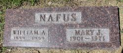
| Description | : | Willa Hieb, 92, of Pierre, died Wednesday, December 12 at Brookstone Village in Omaha, NE. Services were Thursday, December 20 at First United Methodist Church with burial at Riverside Cemetery Willa was born October 1, 1926 in Seneca, SD to William and Mary (Johnson) Nafus. She grew up in Highmore and Holabird where she attended school, graduating from Harrold High School. She was united in marriage to Herman Hieb on June 16, 1946. Willa worked for the County Agents Office in Highmore for a couple of years before moving to Pierre where she worked at the State Treasurer’s... Read More |
frequently asked questions (FAQ):
-
Where is Willa Nafus Hieb's memorial?
Willa Nafus Hieb's memorial is located at: Riverside Cemetery, Pierre, Hughes County, USA.
-
When did Willa Nafus Hieb death?
Willa Nafus Hieb death on 12 Dec 2018 in Omaha, Douglas County, Nebraska, USA
-
Where are the coordinates of the Willa Nafus Hieb's memorial?
Latitude: 44.3608017
Longitude: -100.3071976
Family Members:
Parent

Siblings

Flowers:


Nearby Cemetories:
1. Riverside Cemetery
Pierre, Hughes County, USA
Coordinate: 44.3608017, -100.3071976
2. South Dakota State Capitol Grounds
Pierre, Hughes County, USA
Coordinate: 44.3660100, -100.3448000
3. Fort Pierre Chouteau Cemetery
Fort Pierre, Stanley County, USA
Coordinate: 44.3908700, -100.3878300
4. Mount Calvary Cemetery
Pierre, Hughes County, USA
Coordinate: 44.4197006, -100.3557968
5. Cedar Hill Cemetery
Fort Pierre, Stanley County, USA
Coordinate: 44.3356018, -100.3964005
6. Scotty Philip Cemetery
Fort Pierre, Stanley County, USA
Coordinate: 44.4019012, -100.4036026
7. Byron Township Cemetery
Blunt, Hughes County, USA
Coordinate: 44.4979200, -100.1904700
8. Canning Cemetery
Hughes County, USA
Coordinate: 44.3986890, -100.0278460
9. Holy Name Episcopal Cemetery
Fort Pierre, Stanley County, USA
Coordinate: 44.2694960, -100.0357300
10. Holy Name Chapel Cemetery
Fort Pierre, Stanley County, USA
Coordinate: 44.2694292, -100.0356989
11. Mathews Family Cemetery
Stanley County, USA
Coordinate: 44.1816040, -100.5581080
12. Pleasant Hill Cemetery
Blunt, Hughes County, USA
Coordinate: 44.5135994, -100.0156021
13. Okobojo Cemetery
Sully County, USA
Coordinate: 44.6568985, -100.3647003
14. Meers Cemetery
Stanley County, USA
Coordinate: 44.4116970, -100.7360760
15. Fort Sully Post Cemetery
Sully County, USA
Coordinate: 44.5866480, -100.6087530
16. Holy Faith Cemetery
Lyman County, USA
Coordinate: 44.1356010, -99.9878006
17. Chapelle Cemetery
Hughes County, USA
Coordinate: 44.3025017, -99.8653030
18. Fort Bennett Post Cemetery
Stanley County, USA
Coordinate: 44.6716500, -100.6404200
19. Onida Cemetery
Onida, Sully County, USA
Coordinate: 44.7147000, -100.0650000
20. Immanuel Lutheran Cemetery
Van Metre, Jones County, USA
Coordinate: 44.0958800, -100.7263300
21. Saint Catherines Cemetery
Harrold, Hughes County, USA
Coordinate: 44.2091100, -99.7868200
22. Ascension Cemetery
Canning, Hughes County, USA
Coordinate: 44.1523700, -99.7927100
23. Medicine Hill Cemetery
Harrold, Hughes County, USA
Coordinate: 44.5116997, -99.7453003
24. Saint John Catholic Cemetery
Harrold, Hughes County, USA
Coordinate: 44.5127983, -99.7335968