
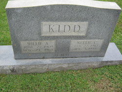
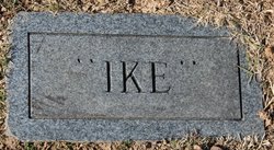
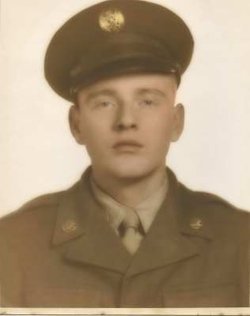
William Alton “Willie” Kidd
| Birth | : | 27 Jun 1909 |
| Death | : | 23 Nov 1968 North Carolina, USA |
| Burial | : | St. Mary's Berkley, Berkley, Mendip District, England |
| Coordinate | : | 51.2435080, -2.2720990 |
| Description | : | William Thomas and Sarah E Kidd |
frequently asked questions (FAQ):
-
Where is William Alton “Willie” Kidd's memorial?
William Alton “Willie” Kidd's memorial is located at: St. Mary's Berkley, Berkley, Mendip District, England.
-
When did William Alton “Willie” Kidd death?
William Alton “Willie” Kidd death on 23 Nov 1968 in North Carolina, USA
-
Where are the coordinates of the William Alton “Willie” Kidd's memorial?
Latitude: 51.2435080
Longitude: -2.2720990
Family Members:
Parent
Spouse

Siblings


Children
Flowers:


Nearby Cemetories:
1. St. Mary's Berkley
Berkley, Mendip District, England
Coordinate: 51.2435080, -2.2720990
2. All Saints Churchyard
Rodden, Mendip District, England
Coordinate: 51.2283600, -2.2892740
3. Beckington Baptist Chapel Burial Ground
Beckington, Mendip District, England
Coordinate: 51.2610760, -2.2897000
4. St George Churchyard
Beckington, Mendip District, England
Coordinate: 51.2635260, -2.2856810
5. East Hill
Frome St Quintin, West Dorset District, England
Coordinate: 51.2272132, -2.3024896
6. East Hill Cemetery
Frome, Mendip District, England
Coordinate: 51.2275940, -2.3030250
7. St. Margaret Churchyard Extension
Corsley, Wiltshire Unitary Authority, England
Coordinate: 51.2191491, -2.2469419
8. Frome Dissenters' Cemetery
Frome, Mendip District, England
Coordinate: 51.2317000, -2.3215000
9. St. John the Baptist Churchyard
Frome, Mendip District, England
Coordinate: 51.2296780, -2.3209480
10. All Saints Churchyard
Lullington, Mendip District, England
Coordinate: 51.2661940, -2.3121800
11. Sheppards Barton Meeting House Burial Ground
Frome, Mendip District, England
Coordinate: 51.2300570, -2.3247620
12. St Lawrence Churchyard
Rode, Mendip District, England
Coordinate: 51.2792750, -2.2765370
13. Holy Trinity Church
Frome, Mendip District, England
Coordinate: 51.2341720, -2.3275820
14. Christ Church Churchyard
Frome, Mendip District, England
Coordinate: 51.2295340, -2.3260130
15. St Mary the Virgin Churchyard
Orchardleigh, Mendip District, England
Coordinate: 51.2576210, -2.3259440
16. Penknap Providence Baptist Chapelyard
Dilton Marsh, Wiltshire Unitary Authority, England
Coordinate: 51.2467910, -2.2059510
17. Christ Church Churchyard
Rode, Mendip District, England
Coordinate: 51.2861620, -2.2790890
18. St Mary's Churchyard
Laverton, Mendip District, England
Coordinate: 51.2757380, -2.3195910
19. St. Lawrence Churchyard
Woolverton, Mendip District, England
Coordinate: 51.2851540, -2.3021790
20. St. Katherine's Churchyard
Frome, Mendip District, England
Coordinate: 51.1957520, -2.3012529
21. Saint Michael & All Angels Churchyard
Buckland Dinham, Mendip District, England
Coordinate: 51.2600540, -2.3522580
22. All Saints Churchyard
Tellisford, Mendip District, England
Coordinate: 51.2997270, -2.2877180
23. Saint Mary Magdalene Churchyard
Great Elm, Mendip District, England
Coordinate: 51.2426040, -2.3647230
24. St Leonard Church
Marston Magna, South Somerset District, England
Coordinate: 51.2058070, -2.3488020