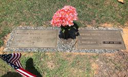
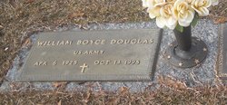
William Boyce “Bill” Douglas
| Birth | : | 6 Apr 1925 |
| Death | : | 13 Oct 1998 Pineville, Mecklenburg County, North Carolina, USA |
| Burial | : | Pleasant Hill United Methodist Church Cemetery, Indian Land, Lancaster County, USA |
| Coordinate | : | 35.0006960, -80.8620870 |
| Inscription | : | US ARMY |
| Description | : | Obit::: FORT MILL - Mr. William "Bill" Boyce Douglas, 73, of 10483 Barberville Road died Tuesday, Oct. 13, 1998, at Lakeview Living Center in Pineville, N.C. The funeral will be 2 p.m. Friday at Pleasant Hill United Methodist Church, with the Rev. Mack Kinnett officiating. Burial will be at the church cemetery. Mr. Douglas served in the Army during World War II. He was the owner of Douglas Convenience Store in the Indian Land Community. He was a member of Indian Land Masonic Lodge No. 414 and a member of Pleasant Hill United Methodist Church. Surviving are his wife, Myrtle Lowder... Read More |
frequently asked questions (FAQ):
-
Where is William Boyce “Bill” Douglas's memorial?
William Boyce “Bill” Douglas's memorial is located at: Pleasant Hill United Methodist Church Cemetery, Indian Land, Lancaster County, USA.
-
When did William Boyce “Bill” Douglas death?
William Boyce “Bill” Douglas death on 13 Oct 1998 in Pineville, Mecklenburg County, North Carolina, USA
-
Where are the coordinates of the William Boyce “Bill” Douglas's memorial?
Latitude: 35.0006960
Longitude: -80.8620870
Family Members:
Spouse
Flowers:
Nearby Cemetories:
1. Pleasant Hill United Methodist Church Cemetery
Indian Land, Lancaster County, USA
Coordinate: 35.0006960, -80.8620870
2. Pleasant Valley Baptist Church Cemetery
Lancaster County, USA
Coordinate: 34.9931793, -80.8495407
3. Silver Run Cemetery
Lancaster County, USA
Coordinate: 35.0149994, -80.8561020
4. Silver Hill Cemetery
Indian Land, Lancaster County, USA
Coordinate: 35.0149280, -80.8557590
5. Independent Bible Baptist Church Cemetery
Charlotte, Mecklenburg County, USA
Coordinate: 35.0179990, -80.8488210
6. Edwards Cemetery
Indian Land, Lancaster County, USA
Coordinate: 34.9770010, -80.8607570
7. Higher Ground Church Cemetery
Indian Land, Lancaster County, USA
Coordinate: 34.9713300, -80.8597020
8. Indian Hill AME Zion Church Cemetery
Indian Land, Lancaster County, USA
Coordinate: 35.0318830, -80.8775660
9. Banks Presbyterian Church Cemetery
Marvin, Union County, USA
Coordinate: 34.9930305, -80.8189697
10. Marvin United Methodist Church Cemetery
Marvin, Union County, USA
Coordinate: 34.9928894, -80.8166580
11. Harrison United Methodist Church Cemetery
Pineville, Mecklenburg County, USA
Coordinate: 35.0415450, -80.8637550
12. Big Pineville AME Zion Church and Cemetery
Pineville, Mecklenburg County, USA
Coordinate: 35.0466280, -80.8562640
13. Elbethel AME Zion Church Cemetery
Belair, Lancaster County, USA
Coordinate: 34.9626270, -80.8299860
14. Old Pleasant Valley Church Cemetery
Fort Mill, York County, USA
Coordinate: 34.9926280, -80.9181210
15. Marvin AME Zion Church Cemetery
Waxhaw, Union County, USA
Coordinate: 34.9920000, -80.8040000
16. Belair Methodist Church Cemetery
Lancaster County, USA
Coordinate: 34.9509964, -80.8433228
17. Old Elbethel AME Zion Church Cemetery
Indian Land, Lancaster County, USA
Coordinate: 34.9631250, -80.8125350
18. Green Hill Cemetery
Fort Mill, York County, USA
Coordinate: 35.0130150, -80.9293700
19. Macedonia Presbyterian Cemetery
Fort Mill, York County, USA
Coordinate: 35.0120690, -80.9331190
20. Old Six Mile Cemetery
Indian Land, Lancaster County, USA
Coordinate: 34.9484250, -80.8220320
21. Unity Cemetery
Fort Mill, York County, USA
Coordinate: 35.0076675, -80.9372864
22. Old Unity Cemetery
Fort Mill, York County, USA
Coordinate: 35.0155230, -80.9360810
23. Unity Presbyterian Church Columbarium
Fort Mill, York County, USA
Coordinate: 35.0080102, -80.9383740
24. Church of God Cemetery
Fort Mill, York County, USA
Coordinate: 34.9934820, -80.9433610


