
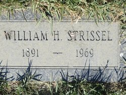
William H Strissel
| Birth | : | 15 Aug 1891 Butler, Day County, South Dakota, USA |
| Death | : | 13 Dec 1969 Chester, Liberty County, Montana, USA |
| Burial | : | Rudyard Cemetery, Rudyard, Hill County, USA |
| Coordinate | : | 48.5659500, -110.5390000 |
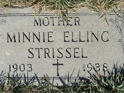
| Description | : | Wiliiam Strissel Services Tuesday Services were Tuesday, Dec. 16 at 2 p.m. in the American Lutheran Church in Rudyard for William Henry Strissel, farmer in the Rudyard area, who died Saturday, Dec. 13 in the Chester hospital. He was 78. Strissel was born Aug. 15, 1891 in Butler, S. D. He came to the Rudyard area in 1909, homesteading northwest of Rudyard, and later moving to a farm a few miles south of Rudyard, where he remained until the present time. In 1926 in Havre he married the former Minnie Elling, who preceded him in death in 1938. Survivors include two sons,... Read More |
frequently asked questions (FAQ):
-
Where is William H Strissel's memorial?
William H Strissel's memorial is located at: Rudyard Cemetery, Rudyard, Hill County, USA.
-
When did William H Strissel death?
William H Strissel death on 13 Dec 1969 in Chester, Liberty County, Montana, USA
-
Where are the coordinates of the William H Strissel's memorial?
Latitude: 48.5659500
Longitude: -110.5390000
Family Members:
Parent

Spouse
Siblings
Children
Flowers:


Nearby Cemetories:
1. Rudyard Cemetery
Rudyard, Hill County, USA
Coordinate: 48.5659500, -110.5390000
2. Hingham Union Cemetery
Hingham, Hill County, USA
Coordinate: 48.5601570, -110.4178980
3. Inverness Cemetery
Hill County, USA
Coordinate: 48.5531340, -110.6688450
4. Bethel Cemetery
Hill County, USA
Coordinate: 48.6685982, -110.6406021
5. Joplin Cemetery
Joplin, Liberty County, USA
Coordinate: 48.5576720, -110.7622930
6. Gildford Hill County Cemetery
Gildford, Hill County, USA
Coordinate: 48.5778008, -110.2957993
7. Cool Spring Colony Cemetery
Rudyard, Hill County, USA
Coordinate: 48.7704000, -110.5860000
8. Milk River Valley Church Graveyard
Hill County, USA
Coordinate: 48.6787180, -110.2261080
9. Cottonwood Lutheran Church Cemetery
Havre, Hill County, USA
Coordinate: 48.4545000, -110.1748000
10. Grace Church Cemetery
Rudyard, Hill County, USA
Coordinate: 48.8269930, -110.6209890
11. Chester Cemetery
Chester, Liberty County, USA
Coordinate: 48.5219002, -110.9807968
12. Saint Wenceslaus Cemetery
Goldstone, Hill County, USA
Coordinate: 48.9002610, -110.5310160
13. Kenilworth Cemetery
Chouteau County, USA
Coordinate: 48.2192001, -110.4188995
14. Erickson Cemetery
Liberty County, USA
Coordinate: 48.3143997, -110.9503021
15. Spring Coulee Cemetery
Hill County, USA
Coordinate: 48.9138985, -110.2035980
16. Box Elder Cemetery
Box Elder, Hill County, USA
Coordinate: 48.3274000, -110.0095000
17. Saint Johns Catholic Cemetery
Havre, Hill County, USA
Coordinate: 48.7625008, -109.9638977
18. Eagle Creek Colony Cemetery
Chester, Liberty County, USA
Coordinate: 48.6976000, -111.2011000
19. Grainbelt Cemetery
Hill County, USA
Coordinate: 48.6828003, -109.8657990
20. Sage Creek Colony Cemetery
Sage Creek Colony, Liberty County, USA
Coordinate: 48.9271000, -110.9735000
21. Lothair Protestant Cemetery
Lothair, Liberty County, USA
Coordinate: 48.4694000, -111.2393100
22. Big Sandy Cemetery
Big Sandy, Chouteau County, USA
Coordinate: 48.1801170, -110.1207500
23. Lothair Catholic Cemetery
Lothair, Liberty County, USA
Coordinate: 48.4687000, -111.2484000
24. Trinity Church Cemetery
Lothair, Liberty County, USA
Coordinate: 48.7263000, -111.2296000